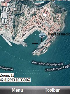
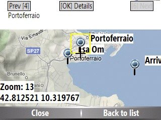
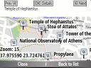
Bluemapia Mobile - View Maps, Search places and geotagged Wikipedia articles, GPS. Mobile Application for bluemapia, the new Web & Mobile Social Mapping for Boaters
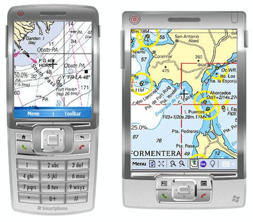
- View Maps (OpenStreetMap and other web map servers)
- Support BSB/NOAA Charts and raster, calibrated charts
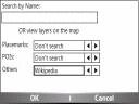
- Search places by name and bluemapia content from the web site
- View geotagged Wikipedia articles on the map
- Use a GPS to display your position on the map and set a terget destination
- Create tracks (gpx file)
- Shoot and upload photos and text to bluemapia for community sharing
Like it? Share with your friends!
If you got an error while installing Themes, Software or Games, please, read FAQ.
Supported operating systems:
Windows Mobile 2003, Windows Mobile 5.0, Windows Mobile 6 Classic, Windows Mobile 6 Professional, Windows Mobile 6.1 Classic, Windows Mobile 6.1 Professional, Windows Mobile 6.5 Professional
Similar Software:
FON Access Points for Lithuania FON Access Points for Lithuania - FON offers you a new Points of Interest service (POIs). This allows you to download FONspots directly to your navigation device.
What does that mean? You can download a Points of Interest file directly to your navigation device
FON Access Points for El Salvador FON Access Points for El Salvador - FON offers you a new Points of Interest service (POIs). This allows you to download FONspots directly to your navigation device.
What does that mean? You can download a Points of Interest file directly to your navigation device
FON Access Points for Slovenia FON Access Points for Slovenia - FON offers you a new Points of Interest service (POIs). This allows you to download FONspots directly to your navigation device.
What does that mean? You can download a Points of Interest file directly to your navigation device
Route Tracker Route Tracker - With Route Tracker you can create routes and add several route points containing text and/or images from your current position. If GPS is available it will take the current longitude, latitude and altitude. Without a GPS module information of the current cell id and the location area code are saved
PocketGPS-Map PocketGPS-Map-The program views calibrated bitmap maps (moving maps) on Pocket PC / WinCE platform. Additionaly it supports using GPS device to retrieve user position and show it (with other marks) in map - making it very handy for geocaching
Navizon Navizon is a software application that will let you get your position, even if you don't have a GPS-enabled phone. Instead of using satellite signals like GPS does, it is triangulating signals from WiFi and Cellular towers. It is based on a collaborative database and the position of WiFi and Cell towers are provided by the users themselves
VITO Navigator II VITO Navigator II-GPS navigation tool for geocaching, hiking and touring to be used without area maps. is our next navigation product, that inherits all advantages of popular VITO Navigator and includes many new features. Elaborated functionality combined with easy-to -use interface gives you unique GPS tool, working fine with the most of GPS receivers
FON Access Points for Algeria FON Access Points for Algeria - FON offers you a new Points of Interest service (POIs). This allows you to download FONspots directly to your navigation device.
What does that mean? You can download a Points of Interest file directly to your navigation device
myRadar myRadar is a location aware radar application that makes use of Wunderground and Accuweather US web services to show real-time, animated Radar Images of your local area regardless of where in the US you might be. This application requires myLocation services to function automatically.
The program will install to /Program Files/myRadar
Other Software by developer «Bluemapia»:
not found
Comments on Bluemapia Mobile:
Comments not found
If you noted an error or download link is broken, please, report it via this page or use comments.
Bluemapia Mobile is compatible with your device Krome Spy (HTC Magician Refresh)

")