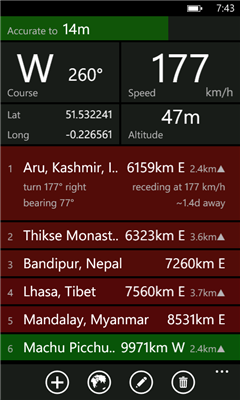
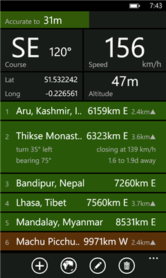
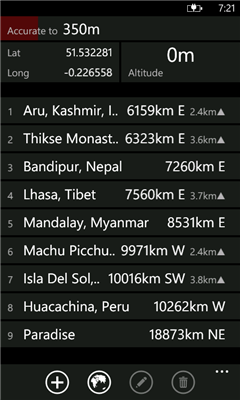
Distant tells you where places are in relation to where you are now. It lists your places in order of distance, and colour codes them so that it is easy to tell at a glance whether you are getting closer or further away. It also tells you how long it will take to get there if you keep moving at the current speed. Places can be entered visually using Bing Maps or directly by entering GPS co-ordinates.
Ever been on a long bus ride and wondered whether there are minutes or hours to go until you reach your destination? Ever had to negotiate with a cab driver who claimed that your destination was "very far away"? Once you got into the cab, did you wonder whether it was going in the right direction at all? Add a waypoint that represents your destination and track your progress in real time.
Going somewhere where you don't have mobile internet access or there is no coverage? Preload your waypoints while you still have access. Once this is done the app no longer requires data or even a signal. It works fine as long as you have a clear view of the sky and can get a GPS fix.
You can also use it to keep track of where you parked your car ...
Like it? Share with your friends!
If you got an error while installing Themes, Software or Games, please, read FAQ.
Supported operating systems:
Windows 10 Mobile, Windows Phone 7, Windows Phone 8
Similar Software:
Waypoints Waypoints - Waypoints is an application that provides information how to get to your destination based on your current location.
Lost? Waypoints can help you. Based on your current location and your destination, it will plot a course for you and provide a detail map and itinerary for you to follow.
Not sure where you want to go? Waypoints can help you
My_Geo_App My_Geo_App - By using this app you can locate theirself in the map.
This app consists lot of things and some of them are:
1. Horizontal accuracy
2. Vertical accuracy
My app will contain the following specifications:
1. My Location Details
2. My Location View
3. Road view/ Arial view
4. U can urself on map
5. Zoom in/zoom out
6. Stop services a
FSX Viewer FSX Viewer you can track your current flight on Microsoft Flight Simulator X. Start FSX Tracer on your desktop PC and follow your aircraft on your WP7 device using a detailed Bing map! Stay updated with your longitude, latitude, speed and others fundamental flight parameters. A must-have for all flight simmers!
Version 1
Dabble Locate Dabble Locate automatically creates and sends a Text or Email Message that contains a link to a map with your current location. This useful message allows your friends and family to open a map and see exactly where you are on the map. No more trying to explain that you are near the large green sign and the tall pine tree over by the north entrance of the west trail
Back Track Free Back Track allows you to easily view your current location and save your position. The saved location can be retrieved at a later time when you may need to find your way back. In addition, Back Track offers directions to help direct you back to the saved location along with a visual route and your current position
Where 2 Go Where 2 Go - The main idea is to replicate the experience of turning a globe while blindfolded and have your finger stop it at a random place. This application has a feature to determine your location anywhere in the world. It will randomly pick a place in the world that you can visit if you so desire. It will also calculate the distance between you and that place
GooglePlaces GooglePlaces is being desing to search your interested places with respect to your current location and range.
1.Quick search places like resturants, shopping mall,banks ,hospitals etc
2.Search with specified name.
3.Use GPS location or Manual location.
4.You can view details in Bing Search by single tap.
5.You can get direction.
6.Save location as snapshot in library
Here I am With "Here I am" you can see your friend and your friend can see you on a map or webbrowser, on a pc or on a windows phone 7 device or other. So its easy to meet him on a unknown area (city center or a music festival).
the best of it: Its free
Kinomap Logger Kinomap Logger - With its integrated GPS chip, your phone will act as data logger to record your track as an NMEA file, compatible with Kinomap.
Start recording and automatically, your location is recorded second by second (with your speed and altitude).
Then you'll be able to see the information on this track and export your NMEA file by email
Destinations Destinations - This is a great way to keep track of the locations of several places and then recall them easily.
Simply add an address or a place name to the list and Destinations will place a pushpin on the map at the location.
Click on an item in the list to see a zoomed in map view that centers on the Destination you have chosen
Other Software by developer «dixiak»:
not found
Comments on Distant:
Comments not found
If you noted an error or download link is broken, please, report it via this page or use comments.
Distant is compatible with your device Lava Iris Win1 Dual SIM