Map Locate Ad - This app is not created to replace Google Maps or other feature rich mapping apps. What this app does is to serve a simple need for certain group of users. Use case is you own jpg,png image files of tradeshow,house,store,apartment,garden etc floorplan and you want to draw pins on different location within the floorplan. Upon tap the pin you want to store some information for that location. So from user perspective, you see the floorplan with pins on them.
App works by assuming the jpg,png floorplan image files are split into many squares along X and Y axis. Each square is then where the app will draw pin in them.
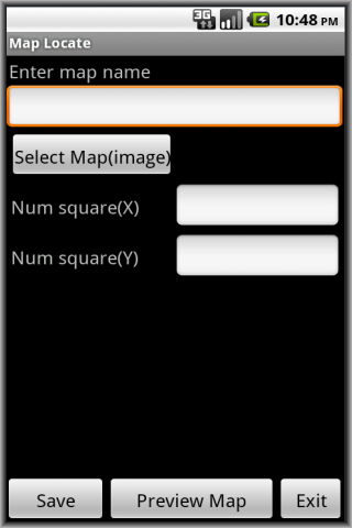
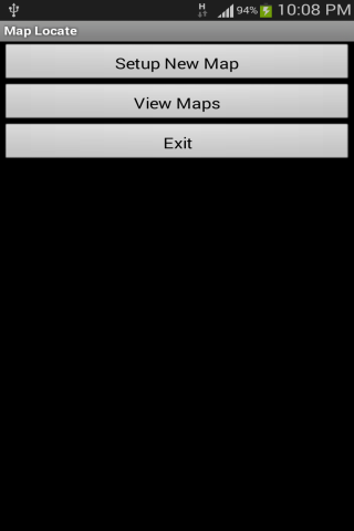
To use, tap Setup New Map. Give a map name, tap Select Map(image) to bring in your jpg,png image file from Gallery. Give a value for number of squares for X and Y axis. Tap Preview Map to preview and notice app take origin (0,0) as bottom left corner. Tap Save to save the map.
Then go to tap View Maps. Tap Edit to change the number of squares for X and Y axis (if you wish). Tap View to see your map. This is where you start to add pins to the map. At the top, specify the X,Y value then tap Add Pin. Pin appear on map. Tap on that pin and a pop-up appear. Add your own location specific information and tap Save. Pinch to zoom in is supported. This help you to see the pin and surrounding close-up. To get back to original, tap the 1:1 button on top. Tap the Grid button to toggle grid on and off.
Important points to note:
- Since most floorplan images are huge, try to scale the image in advance to dimension close to the smart-phone screen size. This ensure when the app render the image it is close to original and your pins drawn on top will look nice.
The application support English, Simplified Chinese, Traditional Chinese display.
Like it? Share with your friends!
Supported operating systems:
Google Android 10.x, Google Android 2.3, Google Android 3.0, Google Android 3.1, Google Android 3.2, Google Android 4.0, Google Android 4.1, Google Android 4.2, Google Android 4.3, Google Android 4.4, Google Android 5.x, Google Android 6.x, Google Android 7.x, Google Android 8.x, Google Android 9.x
Disaster Alert Disaster Alert (by PDC) - Current global disaster info on an interactive map Disaster Alert (by PDC), Active Hazards on an interactive map and in a list as they are occurring around the globe. Additional hazard information can be viewed and shared
TrekBuddy Trekbuddy is a J2ME application to be used with a GPS receiver. It is designed to work with every Java-enabled device. It features capabilities such as: * GPS tracking and simple navigation * bitmap maps (without zoom, you can store bitmap maps with different resolution instead)
CoPilot Live Premium Europe (Android) CoPilot Live Premium Europe (Android) - Now there’s a better way to navigate.
CoPilot Live Premium is the essential voice-guided sat navigation app to get you where you need to go, by the way that suits you best
Street View on Google Maps (Android) Street View on Google Maps (Android) - With Street View on Google Maps, explore the world at street level.
New! Street View smart navigation -- move around by dragging "Pegman" where you want to go.
Try Street View on Google Maps to view street-level imagery from your Android phone
Metro LX Metro LX is a comprehensive guide to the Lisbon Subway providing:
A map of Lisbon Metro (subway) in landscape and portrait modes;
A route planner between stations;
A map route to station from your position;
And detailed information per Station.
What's New in This Release:
· Updated tariff (February 2012);
· Minor bugs fixed on tablets
Google Maps (Android) Google Maps - Now you can get business locations, maps and directions while you're on the go. And it's all free.
· Navigation: Free, voice-guided GPS navigation system using GPS with Google Maps
· Places: Find nearby places and see hours, reviews, etc
CoPilot Live Australia & NZ (Android) CoPilot Live Australia & NZ (Android) - Get a CoPilot! The onboard GPS navigation app that makes every journey better
Modern Compass Modern Compass this compass does what the compass always was intended to do, it helps you locate the destination of your choice.
Using GPS technology and Google maps, this application lets you mark a destination of choice and then shows in what direction that destination lies, as well as how far away it is from your current location
OSMTracker for Android OSMTracker stands for OpenStreetMap Tracker. It allows you to track your journey and mark significant way points. Way points can be marked with a tag using a button, with a quick voice record, a text note or by taking a picture. The various button pages and layouts can be customized to suit your OpenStreetMap activities
Other Software by developer «Sohguanh»:
Country Codes Ad Country Codes Ad - Sometimes you need to call to different countries for work or leisure. This app provides a quick way to get to the different country code for dialing purposes. You use it to search and then tap the item and the default phone dialer app will be launched with the country code you have selected pre-filled in
Checklist Planner Ad Checklist Planner Ad - In our daily lives, very often we uses something that resemble a checklist. Example for every grocery trip, there are some items like rice,bread etc that is a must-buy. For every trip overseas, there are some items like change money, tourist map etc. For every cooking, there are some items like sugar,salt,pepper,onions etc
Carpenter Aid Ad Carpenter Aid Ad - This app provides a feature that some carpenters or those in the wood log industry may need. Given a log, how many different dimension rectangular board size can be 'get' out from it. By varying the dimension size and quantity, the most optimal number of boards can be determined from the log without too much wastage
Package Tracker Ad For ppl who like to install free apps frequently from Android Market to try out, very often you find your smart-phone out of phone memory and have to uninstall some of them to make space for new free app
Interval Reminder Ad The default Android stock alarm in our Android smart-phone provides us a way to schedule alarm at exact date/time. However there will be some time when what we want is a "fixed time interval reminder over a relatively long time span" instead
Stamp Camera Ad This app does not aim to be a full-featured camera app. What it does is do a simple task. Before we take a picture, we want to see a date,timestamp on the preview screen. Then upon tap icon to take picture, the saved pictures have those date,timestamp in the jpg files
Random Quotes Ad Random Quotes Ad - Are you a person who like to read inspirational and motivational quotes once in a while? Do you want to read about other people quotes and get inspired and motivated?
This app serve the need. Different people will submit their own inspirational and motivational quotes and then in return they get to read of other people quotes also
My Sensors Ad For those Android smart-phones that have various sensors built-in, this app attempt to access and retrieve values for display. Three common sensors are shown. Light, Temperature, 3-axis Magnetic field
Image Play Ad This app does not aim to compete as a full-featured image editing tool. What this app does is to provide some basic image editing that beginning or novice users can pick up easily. Say you want to "blend" two images together to see some effects
Random Pick Ad Very often in our daily lives, we have daily decisions to be made. Sometimes we just want to randomly pick one among our options. Instead of flipping a coin for head and tail, this app provides another way to do that choice for you


")
")

")
")
