City Advisor is a Public Transport Navigation Platform for Windows Mobile, providing generic path searching services for cities.
Note: Use the Map Creator to create public transportation maps for use with City Advisor.
· Dynamic depth algorithm
· All graphical, Touch Operation
· Optimized for High-Res screens
· Intelligence Search result
· Map Management
What's New in This Release:
· Rebuilt engines by managed code.
· A Station viewer makes possible to view all transports passed-by and next departures.
· Tourist attractions updated.
· Scrollbars for station selection and map selection
· Tourist site information window, can navigate to an assigned url
· Now you can search with more options simultaneously
· Maps are now in new format, faster and smaller (XMLs are used to edit in MapCreator only)
· Map download - you can now download maps from your phone.
Like it? Share with your friends!
If you got an error while installing Themes, Software or Games, please, read FAQ.
Supported operating systems:
Windows Mobile 2003, Windows Mobile 5.0, Windows Mobile 6 Classic, Windows Mobile 6 Professional, Windows Mobile 6.1 Classic, Windows Mobile 6.1 Professional, Windows Mobile 6.5 Professional
Similar Software:
TrackMe TrackMe - Tool that stores GPS positions and uses that information to generate KML files that can be used by Google Earth or Google Maps for displaying realtime or prerecorded tracks.
The data can be stored locally on your PDA or remotely on a server. You can use my server (free of charge) for storing your data
Metro Melbourne Metro Melbourne - Riding Melbourne's train system? Tired of having to carry around train timetable booklets in your pocket? Want to quickly find out arrival and departure time for any train in Melbourne? Metropolitan Melbourne has the answer for you.
Metropolitan Melbourne ("Metro Melbourne" for short) is an application for Windows Mobile phones
Map of Toulouse (French) / France for City Advisor Map of Toulouse (French) / France for City Advisor - Toulouse / France map in French for City Advisor. It has 2 metro lines.
1. Download the map (zip file)
2. Extract the files in /CityAdvisor/maps
3. Open CityAdvisor -> Maps icon -> Menu -> Refresh
4
Travel Europe - A complete Guide, Road maps, and Phrasebook By Rick Steve Travel Europe - Rick Steves doesn't just list where to travel in Europe, he gives travelers inside information on where to stay, what to visit, and how to get there -- economically and hassle-free. With Rick Steves as their guide, travelers can delve into European culture, make friends with the locals, and experience everything Europe has to offer
Wayfinder Earth (Pocket PC) Wayfinder Earth (Pocket PC) - The world in your hand! Welcome to the ultimate experience of discovering the earth on your mobile phone, for free…
How does it all work?
It's simple. Wayfinder Earth presents you with a 3D globe representing the planet earth, visible on the display of your mobile phone
TravelAddresses TravelAddresses - This program allows you to enter or paste an address and city, state, country etc. and then searches the Live.com online maps for a map with the address centered in the middle of the map. NOTE: You need an internet connection to use this program.
This program requires that you have both the 'BeanDLL
TwitterGPSes TwitterGPSes allows you to view the current GPS and status of your Twitter contacts. Enter the name of each contact to assign to a button. When you tap on the button the persons Twitter page will be downloaded and a Google.com map will display the location. This service is provided by Twitter
Great Britain Pocket A-Z Map 2009 Great Britain Pocket A-Z Map 2009 - This publication has been designed for a Windows® Mobile-based Pocket PC (version 2002 or later) and The Pocket A-Z Viewer. Covering the same area as the Great Britain Mini Road atlas, this publication consists of coloured road mapping of Great Britain which shows motorways, primary routes and main roads
PocketMinesweeper Minesweeper for Pocket PC is a FREE minesweeper game which runs on touch screen devices. Minesweeper has a multi-language interface which includes English, French and Chinese (Simplified and Traditional). You have 4 different levels to face. This game is developed on the HTC Diamond devices and tested both on Diamond and Touch Dual
Map of Shanghai (Chinese) / China for City Advisor Map of Shanghai (Chinese) / China for City Advisor - A Chinese version of Shanghai / China Metro map with all updated 10 metro lines. Find station with first letter of pinyin, ex: the keyword of Shanghai Railway Station is hcz.
1. Download the map (zip file)
2. Extract the files in /CityAdvisor/maps
3. Open CityAdvisor -> Maps icon -> Menu -> Refresh
4
Map of Amiens (French) / France for City Advisor Map of Amiens (French) / France for City Advisor - A map of Amiens' bus transport for City Advisor. Contains line 1 to 11 with full timetable.
Instructions:
1. Download the map (zip file)
2. Extract the files in /CityAdvisor/maps
3. Open CityAdvisor -> Maps icon -> Menu -> Refresh
4
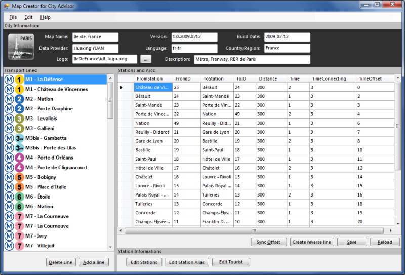
Map Creator for City Advisor Map Creator for City Advisor - Create public transportation maps for use with City Advisor.
What's New in This Release:
· Enable Special TimeTable editing.
· Enable customize peeks.
· Enable CAX format map generation.
· Enable Language-Code Selection for accent insensitive search.
· Accent insensitive station search
Map of Lyon / France for City Advisor Map of Lyon / France for City Advisor. This map includes: 4 Metro, 4 Tramway, 2 Funiculaire, 1 Rhonexpress and 2 Bus.
Instructions:
1. Download the map (zip file)
2. Extract the files in /CityAdvisor/maps
3. Open CityAdvisor -> Maps icon -> Menu -> Refresh
4


 / France for City Advisor")

")


 / China for City Advisor")
 / France for City Advisor")

 / Belgium (Belgique) for City Advisor")
