CacheTrack is a Java application for S60 mobile phones that reads files in the Geocaching.com-GPX-format and helps to find geocaches.
CacheTrack is a free application. You just have to visit a web page containing the latest about CacheTrack on your phone to unlock the application for 24 hours.
· Open GPX files which are compatible with Geocaching.com
· record of your tour
· export the recorded tour as a KML file to be viewed with Google Earth
· export waypoints as "Landmarks" e.g. to view them on Nokia Maps or use the "Navigate to" function of your phone
· create new waypoints
· waypoint projection
· view images referenced by the cache description
· view cache logs
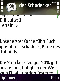
· view cache description
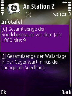
· view cache hints
· can use internal or external GPS receivers
· automate the creation of waypoints based on instructions found in the cache description by the use of a so called "Solver"
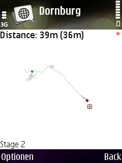
· view an Google Maps image showing the current waypoints
What's New in This Release:
· Can now read new and old Geocaching.com GPX files
Like it? Share with your friends!
Requirements:· Symbian S60 3rd/5th Edition
Supported operating systems:
Java ME, Java Nokia 240x320, Java SE 240x320
Similar Software:
GPS Watch - Plus GPS Watch - Plus - GPS Watch is a powerful yet simple J2ME application that transforms your Mobile Phone and Bluetooth GPS into a professional Global Position Tracking System. GPS Watch integrates with www.trackut
FON Access Points for Morocco FON Access Points for Morocco - FON offers you a new Points of Interest service (POIs). This allows you to download FONspots directly to your navigation device.
What does that mean? You can download a Points of Interest file directly to your navigation device
GpsMid Egypt GpsMid is a free, fully offline, vector based map application for your mobile phone. It displays your current position on a zoomable map and can be used to search for and navigate to roads or points of interest of your liking. As all data is stored in a compact binary format on your mobile phone you will incur no charges for extra data downloads
GpsMid Krakow/Katowice GpsMid is a free, fully offline, vector based map application for your mobile phone. It displays your current position on a zoomable map and can be used to search for and navigate to roads or points of interest of your liking. As all data is stored in a compact binary format on your mobile phone you will incur no charges for extra data downloads
GpsMid Koeln/Bonn GpsMid Koeln/Bonn is a free, fully offline, vector based map application for your mobile phone. It displays your current position on a zoomable map and can be used to search for and navigate to roads or points of interest of your liking. As all data is stored in a compact binary format on your mobile phone you will incur no charges for extra data downloads
TrekBuddy Trekbuddy is a J2ME application to be used with a GPS receiver. It is designed to work with every Java-enabled device. It features capabilities such as: * GPS tracking and simple navigation * bitmap maps (without zoom, you can store bitmap maps with different resolution instead)
GpsMid Ontario GpsMid Ontario is a free, fully offline, vector based map application for your mobile phone. It displays your current position on a zoomable map and can be used to search for and navigate to roads or points of interest of your liking. As all data is stored in a compact binary format on your mobile phone you will incur no charges for extra data downloads
FON Access Points for Palau FON Access Points for Palau - FON offers you a new Points of Interest service (POIs). This allows you to download FONspots directly to your navigation device.
What does that mean? You can download a Points of Interest file directly to your navigation device
GpsMid Ethiopia GpsMid is a free, fully offline, vector based map application for your mobile phone. It displays your current position on a zoomable map and can be used to search for and navigate to roads or points of interest of your liking. As all data is stored in a compact binary format on your mobile phone you will incur no charges for extra data downloads
GpsMid Canada, British Columbia GpsMid Canada, British Columbia is a free, fully offline, vector based map application for your mobile phone. It displays your current position on a zoomable map and can be used to search for and navigate to roads or points of interest of your liking. As all data is stored in a compact binary format on your mobile phone you will incur no charges for extra data downloads
Other Software by developer «Bjoern Quentin»:
MTKTuner A little utility for your J2ME phone to turn WAAS/EGNOS on/off on your MTK powered bluetooth GPS receiver (e.g. the Holux M-1000)
WPAverager WPAverager - WPAverager helps you to create more exact landmarks / waypoints with your mobile device.
You just set how many coordinates it should record and how many of the best ones should be used to average the final location. Then you can save it to the landmarks store. That's it.
You should experiment with the values to get the best results
MMS Effects Type in your message and convert it into an animated multimedia message. Choose from seven effects - no more boring text messages
CacheTrack CacheTrack- is a Java application for S60 mobile phones that reads files in the Geocaching.com-GPX-format and helps to find geocaches.
CacheTrack is a free application. You just have to visit a web page containing the latest about CacheTrack on your phone to unlock the application for 24 hours.
· Open GPX files which are compatible with Geocaching