City Advisor is a Public Transport Navigation Platform for Windows Mobile, providing generic path searching services for cities.
Note: Use the Map Creator to create public transportation maps for use with City Advisor.
· Dynamic depth algorithm
· All graphical, Touch Operation
· Optimized for High-Res screens
· Intelligence Search result
· Map Management
What's New in This Release:
· Rebuilt engines by managed code.
· A Station viewer makes possible to view all transports passed-by and next departures.
· Tourist attractions updated.
· Scrollbars for station selection and map selection
· Tourist site information window, can navigate to an assigned url
· Now you can search with more options simultaneously
· Maps are now in new format, faster and smaller (XMLs are used to edit in MapCreator only)
· Map download - you can now download maps from your phone.
Like it? Share with your friends!
If you got an error while installing Themes, Software or Games, please, read FAQ.
Supported operating systems:
Windows Mobile 2003, Windows Mobile 5.0, Windows Mobile 6 Classic, Windows Mobile 6 Professional, Windows Mobile 6.1 Classic, Windows Mobile 6.1 Professional, Windows Mobile 6.5 Professional
Similar Software:
Global Navigator Global Navigator is the most powerful and easy to use GPS navigation software on your Pocket PC with:3D GPS Navigation all over the world + Offline map and satellite image + Map range download+ 3D street view
TwitsnapsMaps TwitsnapsMaps uses the GPS on your PocketPC to find your current latitude/longitude/speed and altitude and allows you to upload your position via map to Twitter.com. You can customize the maps zoom, and type via the 'Options' in the toolbar. The maps service is provided by Google.com. The map/Twitter storage is from TwitSnaps
PDFJPGMaps PDFJPGMaps - PDFJPGMaps allows you to download a Google.com map of your current GPS and convert to PDF file format. You can draw on the map and also insert text into the maps as well as use the drawing tools. The JPEG libraries are from Independent JPEG Group. The map service is provided by Google.com. The PDF libraries are from JPEG2PDF by Hao Hu 2008
PrettyEarth PrettyEarth
View maps of Earth with PrettyEarth! See current day and night regions, learn geography by taking the quiz, enjoy relief elevation surfaces and measure distances between locations
GPS2clipboard Gets the GPS position data and copy them to the clipboard from where they can be pasted to any application with a paste command
Map4Fun Hong Kong Map4Fun Hong Kong - Going to Hong Kong? just download it for free!
Attractions and shops/hotels/restaurants... in Honk Kong, find coupons/POI instant video/communication links...on hand, and much more of major Asian cities at Map4fun.
1. Hong Kong Information.
2. Useful numbers. 3. Tourist attraction.
4. Sheung Wan/Central area map.
5
Map of Pennsylvania (US State) Map of Pennsylvania (US State) - A map of the Pennsylvania by VITO Technology. Good for intercity travels with SmartMap.
SmartMap is a mobile device application which uses vector and raster maps. It is compatible with any NMEA protocol GPS receiver (Compact Flash socket, serial port, BlueTooth or sleeve)
amAze (LG) AmAze is a first of its kind free navigation and local search service. It is free to download and use and it contains wide coverage of maps including aerial photo in Europe, North America, Australia and parts of Asia and Africa
Livecontacts Mobile Livecontacts Mobile is a mobile application designed for WindowsMobile 5 and 6 mobile phones with a GPS inside. A free and fun way to let your friends know where you are. Install Livecontacts Mobile on your mobile phone and share your location along the way.
Now create a Profile Badge with a Google map and add your location to your Facebook profile page
Map of Lyon / France for City Advisor Map of Lyon / France for City Advisor. This map includes: 4 Metro, 4 Tramway, 2 Funiculaire, 1 Rhonexpress and 2 Bus.
Instructions:
1. Download the map (zip file)
2. Extract the files in /CityAdvisor/maps
3. Open CityAdvisor -> Maps icon -> Menu -> Refresh
4
Map of Amiens (French) / France for City Advisor Map of Amiens (French) / France for City Advisor - A map of Amiens' bus transport for City Advisor. Contains line 1 to 11 with full timetable.
Instructions:
1. Download the map (zip file)
2. Extract the files in /CityAdvisor/maps
3. Open CityAdvisor -> Maps icon -> Menu -> Refresh
4
Map of Shanghai (Chinese) / China for City Advisor Map of Shanghai (Chinese) / China for City Advisor - A Chinese version of Shanghai / China Metro map with all updated 10 metro lines. Find station with first letter of pinyin, ex: the keyword of Shanghai Railway Station is hcz.
1. Download the map (zip file)
2. Extract the files in /CityAdvisor/maps
3. Open CityAdvisor -> Maps icon -> Menu -> Refresh
4
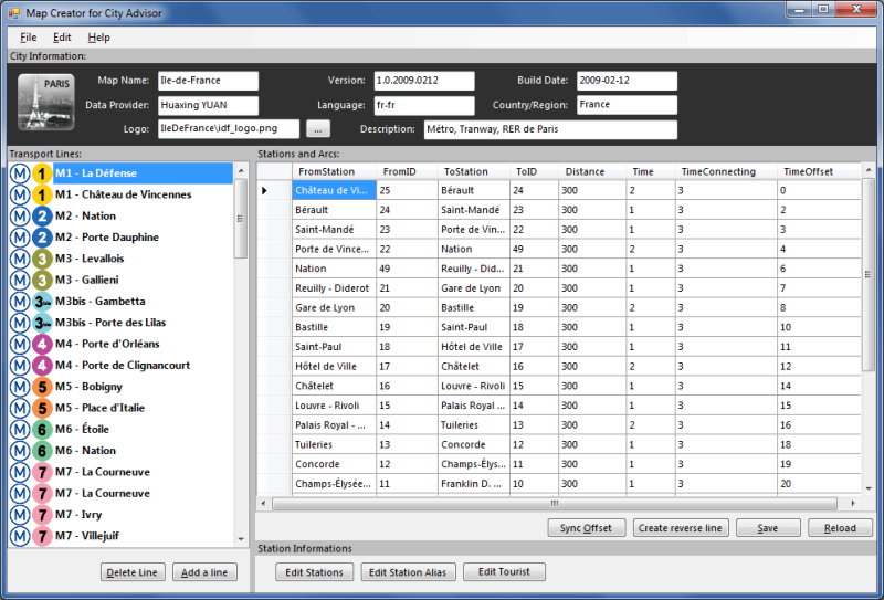
Map Creator for City Advisor Map Creator for City Advisor - Create public transportation maps for use with City Advisor.
What's New in This Release:
· Enable Special TimeTable editing.
· Enable customize peeks.
· Enable CAX format map generation.
· Enable Language-Code Selection for accent insensitive search.
· Accent insensitive station search
PocketMinesweeper Minesweeper for Pocket PC is a FREE minesweeper game which runs on touch screen devices. Minesweeper has a multi-language interface which includes English, French and Chinese (Simplified and Traditional). You have 4 different levels to face. This game is developed on the HTC Diamond devices and tested both on Diamond and Touch Dual


![USA-PR [Puerto Rico / English] Map for EagleEye PDA Tracking System](https://static.mobyware.org/data/images/def_program_reduced.png "USA-PR [Puerto Rico / English] Map for EagleEye PDA Tracking System")
")
")

 / Belgium (Belgique) for City Advisor")

 / France for City Advisor")
 / China for City Advisor")

