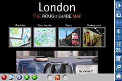
Rough Guides Map London... These guides are a series of fantastic interactive maps.
Produced in conjunction with the premier travel publisher Rough Guides.
Discover and explore London using full colour interactive linked maps, in this simple to use PDA version of The Rough Guides London.
Find all the top tourist spots and key attractions with ease, information on the city and its sights can be quickly displayed with links to photographs and map locations. All in a superb easy to use interface.
If you''re travelling to London, be sure you don''t leave home without this guide on your PDA.
The Rough Guide city maps includes:
Fully scrollable and interactive maps of the city.
Tap any location to display information and available links.
Intuitive navigation bar meaning you are never more than one click away from the information you require.
Map links allow you to directly link to other maps, photographs, or detailed views.
Categorised Find feature allowing you to quickly find any street, place of interest or station.
Categorised Information feature providing a wealth of information on the city, places of interest, etc.
1-Click Home feature, keeping the Home map always at hand.
Zoom function on all maps.
Special Offer Only $20.00
Hi Res & landscape displays supported.
Like it? Share with your friends!
If you got an error while installing Themes, Software or Games, please, read FAQ.
Supported operating systems:
Pocket PC 2002, Windows Mobile 2003, Windows Mobile 5.0, Windows Mobile 6 Classic, Windows Mobile 6 Professional, Windows Mobile 6.1 Classic, Windows Mobile 6.1 Professional, Windows Mobile 6.5 Professional
Similar Software:
Live Search Mobile Get search, directions, traffic, weather, gas prices and more ! Free from Microsoft
Now with Speech Recognition—just say what you’re looking for!
We realize that your mobile phone isn’t the same as your PC
RideSchedulesCUMTD RideSchedulesCUMTD - The RideSchedules application is a full-featured public transit assistant that includes updatable schedules, countdowns, maps, favorite stops, directions, guides, tracking tools, alarms, announcements, parking meter, vehicle finder, realtime vehicle locations, offline support, and convenient access to transit provider services
Map of New Jersey (US State) Map of New Jersey (US State) - A map of the New Jersey by VITO Technology. Good for intercity travels with SmartMap.
SmartMap is a mobile device application which uses vector and raster maps. It is compatible with any NMEA protocol GPS receiver (Compact Flash socket, serial port, BlueTooth or sleeve)
Map of Oregon (US State) Map of Oregon (US State) - A map of the Oregon by VITO Technology. Good for intercity travels with SmartMap.
SmartMap is a mobile device application which uses vector and raster maps. It is compatible with any NMEA protocol GPS receiver (Compact Flash socket, serial port, BlueTooth or sleeve)
Orionic Orionic-Pocket PC application simulating the night sky.
Update Description:
v1.2:
- Added labels of grid coordinates.
- Fixed a stupid bug in the Julian date calculation - cause of wrong stars possitions
Rough Guides Map Barcelona Rough Guides Map Barcelona... These guides are a series of fantastic interactive maps.
Produced in conjunction with the premier travel publisher Rough Guides.
Discover and explore Barcelona using full colour interactive linked maps, in this simple to use PDA version of The Rough Guides Barcelona
Tube 2 Engine (Pocket PC) Tube 2 Engine (Pocket PC) - Transform your PDA into a fully scrollable detailed map of one of the worlds subway or metro systems.
See your journeys come alive with a superb animated display.
Save hours by automatically having the quickest routes to hand, with all the details you need including line changes, platform directions and accurate journey times
Map of Utah (US State) Map of Utah (US State) - A map of the Utah by VITO Technology. Good for intercity travels with SmartMap.
SmartMap is a mobile device application which uses vector and raster maps. It is compatible with any NMEA protocol GPS receiver (Compact Flash socket, serial port, BlueTooth or sleeve)
Vienna Metro 10 for iPad Vienna Metro 10 - The new Zuti Vienna Metro map makes it easy to travel in and around the city using the Metro (U-Bahn), Suburban Rail (S-Bahn) or Tram (Straßenbahn) systems
Tube Vienna (UIQ) Tube Vienna (UIQ) - Our award winning and highly acclaimed application that guides you around the metro system of Vienna is now available for your Symbian UIQ phone.
An essential addition to your P800 / P900 / P910 if you travel in or around this city.
· A detailed clear colour map of the Vienna metro system fully scrollable.
· Quick find station utility
Tube Philadelphia (UIQ) Tube Philadelphia (UIQ) - An award winning and highly acclaimed application that guides you around the rail system of Philadelphia.
An essential addition to your Sony Ericsson P800 / P900 / P910 if you travel in or around this city
· A detailed clear colour map of the Philadelphia rail system fully scrollable.
· Quick find station utility
Tube 2 New York City Pro (UIQ) Tube 2 New York City Pro (UIQ) - This map package for Tube 2 consists of a fully scrollable detailed map of the New York City MTA subway system and linked high quality street maps of Manhattan. Also included are additional reference maps of the rail systems surrounding NYC
Tube New York Pro (2009 Edition) Tube New York Pro
New release with GPS support & Live travel information.
This superb map package for Tube is the ideal map for anyone who needs to get around New York City using the MTA subway system and would like to know just exactly where they are
Tube 2 Barcelona (UIQ) Tube 2 Barcelona (UIQ) - This map package for Tube 2 consists of a fully scrollable detailed map of the Barcelona metro & rail system.
Plan journeys on the metro system, list details of the quickest routes and see a superb animated display of your journey tracking around the system map
Tube 2 Washington (UIQ) Tube 2 Washington (UIQ) - This map package for Tube 2 consists of a fully scrollable detailed map of the Washington metro system.
Plan journeys on this system, list details of the quickest routes and see a superb animated display of your journey tracking around the system map
Tube 2 Barcelona (Palm OS) Tube 2 Barcelona (Palm OS) - This map package for Tube 2 consists of a fully scrollable detailed map of the Barcelona metro & rail system.
Plan journeys on the metro system, list details of the quickest routes and see a superb animated display of your journey tracking around the system map
Tube Paris (Series 60) Tube Paris (Series 60) - Our highly acclaimed Tube application that guides you around the complex metro system of Paris is now available for your Series 60 Symbian powered phone. An essential addition to your phone for locals and tourists alike.
· A detailed clear colour map of the transport system fully scrollable.
· Quick find station utility
Chicago Metro by Zuti Chicago Metro by Zuti - Chicago Metro map makes it easy to travel in and around the city using the CTA rapid transport system, the commuter services of Metrarail, Northern Indiana Commuter Transportation District and also the Water Taxi services


 Hi Res & landscape displays supported.

")
")


")
![USA-ID [Idaho] Map for EagleEye PDA Tracking System](https://static.mobyware.org/data/images/def_program_reduced.png "USA-ID [Idaho] Map for EagleEye PDA Tracking System")
")

")
")
")
")
")
")
")
")
