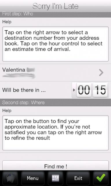
Sorry I'm Late - People are always in a hurry to get somewhere. A common issue is to inform someone waiting for us that we are, let’s say, a bit late and maybe reassure him that we will be there in some time. It would be great if we could send a message to that someone telling him our approximate location and an estimate time to reach the destination (maybe along with some excuses).
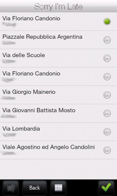
Sorry I'm Late was developed to achieve this task. This application allows a user to get his approximate location and then send it to someone else through an SMS. It has a friendly user interface and uses CellID localization instead of GPS. Also, it sends a more human readable message, unlike other similar applications which use GPS positioning to get a precise localization but then they send Latitude and Longitude coordinates or Google Maps links. This application uses street names instead of coordinates.
· Doesn't require GPS antenna
· Finger friendly UI thanks to SenseSDK from Steady Software
· Call history access to guess the most probable recipients
· Native SMS application used to send message to allow last minute changes
· Currently localized in English and Italian
What's New in This Release:
· added compression support on network calls to reduce bandwidth usage
Like it? Share with your friends!
If you got an error while installing Themes, Software or Games, please, read FAQ.
Supported operating systems:
Windows Mobile 5.0, Windows Mobile 6 Classic, Windows Mobile 6 Professional, Windows Mobile 6.1 Classic, Windows Mobile 6.1 Professional, Windows Mobile 6.5 Professional
Similar Software:
GPSChannels GPSChannels can help you to get a better understanding of the best places to place your unit when trying to get a GPS fix. Start the program and it will display the NMEA logs and the total number of viewable satellites. You can also save the NMEA logs to a file
GPS Tuner Essentials Full Version with United States Basic Map Content GPS Tuner Essentials Full Version with United States Basic Map Content is designed specifically for off-road use: its large buttons, selectable tool window size, multiple Compass views and the built-in Tele Atlas map makes it extremely user-friendly and reliable
Gpx2bin Gpx2bin - Gpx2bin is a GPS track converter software for Windows Mobile.
It can be used to convert .gpx, .mps, .plt and .nmea formats to the tracks.bin file used by Navitel Navigator to see the track as "blue line."
What's New in This Release:
· A problem with large files opening was fixed
FON Access Points for Jamaica FON Access Points for Jamaica - FON offers you a new Points of Interest service (POIs). This allows you to download FONspots directly to your navigation device.
What does that mean? You can download a Points of Interest file directly to your navigation device
FON Access Points for Ireland FON Access Points for Ireland - FON offers you a new Points of Interest service (POIs). This allows you to download FONspots directly to your navigation device.
What does that mean? You can download a Points of Interest file directly to your navigation device
FON Access Points for Mexico FON Access Points for Mexico - FON offers you a new Points of Interest service (POIs). This allows you to download FONspots directly to your navigation device.
What does that mean? You can download a Points of Interest file directly to your navigation device
SIGLOG SIGLOG - A Windows Mobile application that logs latitude, longitude, signal strength, mobile country code, mobile network code, location area code, CellID.
Written in Win32 C++ it's lean, mean, rather basic, but it does the job. It requires a phone with GPS, as it calls the Microsoft intermediate GPS driver
FON Access Points for Israel FON Access Points for Israel - FON offers you a new Points of Interest service (POIs). This allows you to download FONspots directly to your navigation device.
What does that mean? You can download a Points of Interest file directly to your navigation device
MapGoogler MapGoogler uses the GPS on your PocketPC to find your current latitude/longitude/speed and altitude and allows you to view your position on a map from the Google.com maps service. You can customize the maps zoom, and type via the 'Options' in the toolbar. The maps service is provided by Google
Mobile First Aid Mobile First Aid - According to a recent study (Gray, 2008) there are abount 1.8 mobile phones per person around the world. Since everyone of us can find himself in the need to give some first aid assistance to someone injured, it is simple to merge these two data and say "why don't give these people a first aid application to be installed on their mobile phones