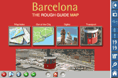
Rough Guides Map Barcelona... These guides are a series of fantastic interactive maps.
Produced in conjunction with the premier travel publisher Rough Guides.
Discover and explore Barcelona using full colour interactive linked maps, in this simple to use PDA version of The Rough Guides Barcelona.
Find all the top tourist spots and key attractions with ease, information on the city and its sights can be quickly displayed with links to photographs and map locations. All in a superb easy to use interface.
If you''re travelling to Barcelona, be sure you don''t leave home without this guide on your PDA.
The Rough Guide city maps includes:
Fully scrollable and interactive maps of the city.
Tap any location to display information and available links.
Intuitive navigation bar meaning you are never more than one click away from the information you require.
Map links allow you to directly link to other maps, photographs, or detailed views.
Categorised Find feature allowing you to quickly find any street, place of interest or station.
Categorised Information feature providing a wealth of information on the city, places of interest, etc.
1-Click Home feature, keeping the Home map always at hand.
Zoom function on all maps.
Special Offer Only $20.00
Hi Res & landscape displays supported.
Like it? Share with your friends!
If you got an error while installing Themes, Software or Games, please, read FAQ.
Supported operating systems:
Pocket PC 2002, Windows Mobile 2003, Windows Mobile 5.0, Windows Mobile 6 Classic, Windows Mobile 6 Professional, Windows Mobile 6.1 Classic, Windows Mobile 6.1 Professional, Windows Mobile 6.5 Professional
Speereo Voice Translator: English-Danish (WM) Speereo Voice Translator (SVT) is an ideal companion for traveling on business or leisure and also is an excellent aid for business communication. Running on Windows Mobile and Symbian based mobile devices it contains of over 4000 phrases in each of 16+ languages and many other useful features
Map of South Dakota (US State) Map of South Dakota (US State) - A map of the South Dakota by VITO Technology. Good for intercity travels with SmartMap.
SmartMap is a mobile device application which uses vector and raster maps. It is compatible with any NMEA protocol GPS receiver (Compact Flash socket, serial port, BlueTooth or sleeve)
Free Earth Elevation Map for PrettyMap/PrettyEarth Earth Elevation Map for PrettyMap/PrettyEarth - This is a medium-resolution, free Earth elevation map for PrettyMap and PrettyEarth. It contains one elevation sample per 4 km, approximately.
Note: large file (16 MB download, 55 MB after installing).
Note for PrettyEarth users: this map will be installed to Program FilesPrettyMapmaps
Great Britain Pocket A-Z Map 2009 Great Britain Pocket A-Z Map 2009 - This publication has been designed for a Windows® Mobile-based Pocket PC (version 2002 or later) and The Pocket A-Z Viewer. Covering the same area as the Great Britain Mini Road atlas, this publication consists of coloured road mapping of Great Britain which shows motorways, primary routes and main roads
TravelAddresses TravelAddresses - This program allows you to enter or paste an address and city, state, country etc. and then searches the Live.com online maps for a map with the address centered in the middle of the map. NOTE: You need an internet connection to use this program.
This program requires that you have both the 'BeanDLL
BackCountry Navigator BackCountry Navigator is fun-filled navigation software for the outdoor adventurer. Use it in a variety of outdoor adventures, from kayak touring to geocaching. This is a summary of what you can do with the product.
BackCountry uses free topo and aerial maps for the United States, downloaded directly from Terraserver-USA
amAze (Samsung) AmAze is a first of its kind free navigation and local search service. It is free to download and use and it contains wide coverage of maps including aerial photo in Europe, North America, Australia and parts of Asia and Africa
MapBook MapBook - MapBook - store and view various maps on your Pocket PC.
MapBook requires that you have both the 'BeanDLL.dll' file ** and ** the runtime files for Visual Basic on your PocketPC computer. Simply unzip the file for your processor and place the DLL file in the 'Windows' folder of your PocketPC computer. For free support on installing, email the author
Washington Metro for iPad by Zuti The new Washington Metro 10 map makes it easy to travel in and around the city using the WMATA Metro, MARC and VME systems. Also included are the Potomac river taxi routes and the DC Circulator bus routes
Rough Guides Map Rome Rough Guides Map Rome... These guides are a series of fantastic interactive maps.
Produced in conjunction with the premier travel publisher Rough Guides.
Discover and explore Rome using full colour interactive linked maps, in this simple to use PDA version of The Rough Guides Rome
Tube 2 Paris Touristic (UIQ) Tube 2 Paris Touristic (UIQ) - This map package for Tube 2 is the ideal map for the tourist or business traveller who needs to get around Paris using the metro system and would like to know just exactly where they are. The map geographically locates all the central stations, making it much more informative than the official topological map
New York Subway 10 for iPad New York Subway 10 - The “New York Subway” application is a superb geographically based map and route planner for the New York public transport systems
Edinburgh Mini A-Z Edinburgh Mini A-Z - This street map of Edinburgh covers an area extending to Cramond, Granton, Leith, Portobello, Musselburgh, Whitecraig, Dalkeith, Bonnyrigg (part), Loanhead, Fairmilehead, Juniper Green, Currie, Balerno, and Edinburgh Airport.
Major buildings are colour-coded to indicate places of interest and other buildings that are open to the public
Paris Metro for iPad by Zuti Paris Metro 10 - This Zuti application contains a visually unique map of the Paris transport system and a superb animated journey planner to help you get around the Metro, RER, SNCF, Tram, Tvm, and Vogueo services. Now revised and updated to include a larger geographic area which covers more of the outlying areas surrounding Paris
Tube Washington (Series 60) Tube Washington (Series 60) - Our highly acclaimed Tube application that guides you around the Washington D.C. metro system is now available for your Series 60 Symbian powered phone. An essential addition to your phone for locals and tourists alike.
· A detailed clear colour map of the transport system fully scrollable.
· Quick find station utility
Tube 2 Tokyo (UIQ) Tube 2 Tokyo (UIQ) - This map package for Tube 2 consists of a fully scrollable detailed map of the Tokyo city subway & JR rail system
TUBE 2 Amsterdam Pro TUBE 2 Amsterdam Pro - This map package for Tube 2 consists of a fully scrollable detailed map of the Amsterdam tram & metro system and linked street maps of central Amsterdam.
Plan journeys on the tram & metro system, list details of the quickest routes and see a superb animated display of your journey tracking around the system map
Tube 2 Berlin (UIQ) Tube 2 Berlin (UIQ) - This map package for Tube 2 consists of a fully scrollable detailed map of the Berlin Metro (U-Bahn/S-Bahn).
Plan journeys on this system, list details of the quickest routes and see a superb animated display of your journey tracking around the system map.
Berlin is the capital and largest city in Germany


 Hi Res & landscape displays supported.
 ![USA-TN [Tennessee] Map for EagleEye PDA Tracking System](https://static.mobyware.org/data/images/def_program_reduced.png "USA-TN [Tennessee] Map for EagleEye PDA Tracking System")
")
")


")


")


")
")

")