Platforms: iPhone, iPad, iPod Touch, Apple iPhone OS
Categories: Travel & Navigation
Upload date: 29 Oct 11
Developer: Visual IT
License: Commercial
Price: 9.99 $
Downloads: 16
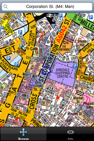
Manchester Mini A-Z - "Manchester Mini A-Z" is a digital rendition of the famous Geographers Company Mini A-Z Atlas for Manchester. This mini street atlas includes coverage of Kearsley, Whitefield, Middleton, Chadderton, Oldham, Walkden, Swinton, Prestwich, Failsworth, Worsley, Salford, Droylsden, Ashton-Under-Lyne, Eccles, Trafford Park, Salford, Dukinfield, Urmston, Stretford, Levenshulme, Reddish, Denton, Sale, Brinnington, Stockport, Wythenshawe, Cheadle and Manchester Airport.
The index section of the atlas lists: streets, walkways, places of interest, selected flats, place and area names plus National Rail and Metrolink stations. Also included is a listing of hospitals, hospices, and NHS Walk-in Centres that are covered by this atlas
This map is drawn by real cartographers with the detailed care and human touch of emphasis and colour that A-Z are famous for. Internet maps are OK but you really can’t beat the genuine article.
With the maps installed on your device there is never any need for an internet connection enabling you to access the map anywhere and at anytime. This application starts up in under 5 seconds and can find any location on the map in under 2 seconds. You can also use your inbuilt location services (GPS, Wifi, etc) to locate your position on the map.
Visual IT have partnered with the “Geographers A-Z Map Company” and negotiated a license to produce this map for iPhone or iPod Touch users at this very competitive price.
What's New in This Release:
· Support for retina display
· New "Measure Tool"
· Bug fix for the next iOS release
Like it? Share with your friends!
If you got an error while installing Themes, Software or Games, please, read FAQ.
Supported operating systems:
Apple iOS 10.x (iPad), Apple iOS 10.x (iPhone), Apple iOS 11.x (iPad), Apple iOS 12.x (iPad), Apple iOS 12.x (iPhone), Apple iOS 4.0.x (iPhone), Apple iOS 4.0.x (iPod Touch), Apple iOS 4.2.x (iPad), Apple iOS 4.2.x (iPhone), Apple iOS 4.2.x (iPod Touch), Apple iOS 4.3.x (iPad), Apple iOS 4.3.x (iPhone), Apple iOS 4.3.x (iPod Touch), Apple iOS 5.0 (iPad), Apple iOS 5.0 (iPhone), Apple iOS 5.0 (iPod Touch), Apple iOS 6.0 (iPad), Apple iOS 6.0 (iPhone), Apple iOS 6.0 (iPod Touch), Apple iOS 7.0 (iPad), Apple iOS 7.0 (iPhone), Apple iOS 7.0 (iPod Touch), Apple iOS 8.x (iPad), Apple iOS 8.x (iPhone), Apple iOS 8.x (iPod Touch), Apple iOS 9.x (iPad), Apple iOS 9.x (iPhone), Apple iOS 9.x (iPod Touch), Apple iPhone OS 3.1.x, Apple iPhone OS 3.1.x (iPod Touch), Apple iPhone OS 3.2.x (iPad)
Other Software by developer «Visual IT»:
Chicago Metro for iPad by Zuti Chicago Metro for iPad by Zuti - Chicago Metro map makes it easy to travel in and around the city using the CTA rapid transport system, the commuter services of Metrarail, Northern Indiana Commuter Transportation District and also the Water Taxi services
New York Subway for iPad by Zuti New York Subway for iPad by Zuti - The "New York Subway" application is a superb geographically based map and route planner for the New York public transport systems
Tube 2 Berlin (UIQ) Tube 2 Berlin (UIQ) - This map package for Tube 2 consists of a fully scrollable detailed map of the Berlin Metro (U-Bahn/S-Bahn).
Plan journeys on this system, list details of the quickest routes and see a superb animated display of your journey tracking around the system map.
Berlin is the capital and largest city in Germany
London Central Bus 10 for iPad London Central Bus 10 for iPad - The new Zuti London Bus map has finally arrived, making it easy to travel by bus anywhere in central London. This clear and colourful map covers a detailed street level area of 6 miles by 4 miles and includes over 1300 bus stops and 189 bus routes
Tube 2 Dublin (UIQ) Tube 2 Dublin (UIQ) - This map package for Tube 2 consists of a fully scrollable detailed map of the Dublin rail system.
Plan journeys on this system, list details of the quickest routes and see a superb animated display of your journey tracking around the system map
Tube 2 Atlanta (UIQ) Tube 2 Atlanta (UIQ) - This map package for Tube 2 consists of a fully scrollable detailed map of the Atlanta rail system.
Plan journeys on this system, list details of the quickest routes and see a superb animated display of your journey tracking around the system map
TUBE 2 Paris (Blackberry) TUBE 2 Paris (Blackberry)
Tube 2 Paris
Transform your Blackberry into a fully scrollable detailed map of the Paris Metro system.
Plan journeys on the Paris Metro system, have the quickest routes to hand, with all the details you need including line changes, platform directions and accurate journey times
Tube 2 Chicago Pro (UIQ) Tube 2 Chicago Pro (UIQ) - This map package for Tube 2 consists of a fully scrollable detailed map of the Chicago metro & commuter rail system and linked street maps of central Chicago.
Plan journeys on the metro system, list details of the quickest routes and see a superb animated display of your journey tracking around the system map
Tube 2 Madrid (UIQ) Tube 2 Madrid (UIQ) - This map package for Tube 2 consists of a fully scrollable detailed map of the Madrid metro system.
Plan journeys on this system, list details of the quickest routes and see a superb animated display of your journey tracking around the system map
Tube 2 Baltimore (UIQ3) Tube 2 Baltimore (UIQ3) - This map package for Tube 2 consists of a fully scrollable detailed map of the Baltimore metro & rail system.
Plan journeys on this system, list details of the quickest routes and see a superb animated display of your journey tracking around the system map


")

")
")
")
")
")
")