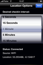
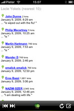
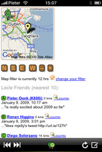
Locle is a mobile application that lets users see where their friends and family are without the need for GPS. Wherever you are, always find out where people are and meet them for lunch, drinks or whatever you want to do. Just make sure you don't miss out on anything.
Like it? Share with your friends!
If you got an error while installing Themes, Software or Games, please, read FAQ.
Supported operating systems:
Google Android 1.0, Google Android 1.5, Google Android 1.6, Google Android 10.x, Google Android 2.0, Google Android 2.1, Google Android 2.2, Google Android 2.3, Google Android 3.0, Google Android 3.1, Google Android 3.2, Google Android 4.0, Google Android 4.1, Google Android 4.2, Google Android 4.3, Google Android 4.4, Google Android 5.x, Google Android 6.x, Google Android 7.x, Google Android 8.x, Google Android 9.x, Java ME, Java Nokia 240x320, Java SE 240x320, Palm OS 3.x, Palm OS 4.x, Palm OS 5.x, Pocket PC 2002, RIM BlackBerry OS 4.0, RIM BlackBerry OS 4.1, RIM BlackBerry OS 4.2, RIM BlackBerry OS 4.3, RIM BlackBerry OS 4.5, RIM BlackBerry OS 4.6, RIM BlackBerry OS 4.7, RIM BlackBerry OS 5.0, RIM BlackBerry OS 6.0, Windows Mobile 2003, Windows Mobile 5.0, Windows Mobile 6 Classic, Windows Mobile 6 Professional, Windows Mobile 6.1 Classic, Windows Mobile 6.1 Professional, Windows Mobile 6.5 Professional
Similar Software:
MyGPS PDA MyGPS_PDA - a light version of MyGPS software for Pocket PC systems. It reads the NMEA sentences coming from a GPS device connected to the Pocket PC and shows your position on a calibrated map. A calibrated map can be generated using MyGPS for PC and starting from any raster image file (.bmp, .jpg, .gif). MyGPS_PDA requires the Ewe VM installed on the Pocket PC
amAze (Samsung) AmAze is a first of its kind free navigation and local search service. It is free to download and use and it contains wide coverage of maps including aerial photo in Europe, North America, Australia and parts of Asia and Africa
Travel Beijing, China. Illustrated Guide, Phrasebook and Maps. Travel Beijing, China. Illustrated Guide, Phrasebook and Maps. - An illustrated city guide, phrasebook, and maps. Indulge Yourself with a personal tour guide on Your PDA. FREE General chapter, basic phrasebook, and a map in the trial version.
Features
Fully illustrated.
Historical overviews.
Interesting facts
Travel Hamburg, Germany - Illustrated Guide, Phrasebook and Maps. FREE general info, map in trial Travel Hamburg, Germany - Illustrated Guide, Phrasebook and Maps. FREE general info, map in trial - An illustrated city guide, phrasebook, and maps. Indulge Yourself with a personal tour guide on Your PDA. FREE General chapter, basic phrasebook, and a map in the trial version.
Features
Fully illustrated.
Historical overviews
Map of Swaziland Map of Swaziland - A map of Swaziland. Good for intercity travels with SmartMap.
Layers include:
Towns
Settlements
Airports
Roads
Railroads
Rivers
Inland water
Administrative borders
International borders
Trees
Map scale is 1:1 million.
Good for use with any version of SmartMap. SmartMap can be purchased here
A-Z Mini Birmingham Street Atlas A-Z Mini Birmingham Street Atlas - From the publishers of London''s best selling paperback street atlas comes this publication designed for a Windows® Mobile-based Pocket PC (version 2002 or later) and Pocket A-Z Viewer (included)
redBANG Shenzhen 18 TOP SIGHTS 2006 THE BEST MOBILE GRAPHICS YOU HAVE EVER SET YOUR EYES ON
This TOP 18 sights map contains all THE TOP locations at your finger tips. Simple and easy to use multi step zoom in & out function map as well as movement in any direction
Map of Uruguay Map of Uruguay - A map of Uruguay. Good for intercity travels with SmartMap.
Layers include:
Towns
Settlements
Airports
Roads
Railroads
Rivers
Inland water
Administrative borders
International borders
Trees
Map scale is 1:1 million.
Good for use with any version of SmartMap. SmartMap can be purchased here
Map of Trinidad and Tobago Map of Trinidad and Tobago - A map of Trinidad and Tobago. Good for intercity travels with SmartMap.
Layers include:
Towns
Settlements
Airports
Roads
Railroads
Rivers
Inland water
Administrative borders
International borders
Trees
Map scale is 1:1 million.
Good for use with any version of SmartMap
MapFolderer MapFolderer uses GPS to find your current location and downloads a JPEG map of the area with a custom name. The maps are tagged with the GPS lat/lng on each JPEG file. You can also view the maps on the built in map viewer. The maps service is provided by Google
Other Software by developer «Leprecian»:
not found
Comments on Locle:
Comments not found
If you noted an error or download link is broken, please, report it via this page or use comments.
Locle is compatible with your device Medion MDPPC 100 (MD7200)
")


")


