GPS Handset Tracking, by Btracking.com (1 Month Subscription)
Version: 1.0
Platforms: Android
Categories: Travel & Navigation
Upload date: 20 Dec 11
Developer: Herceg Network Inc
License: Freeware
Downloads: 1327 File Size: 162 Kb
GPS Handset Tracking, by Btracking.com (1 Month Subscription) - This application delivers real-time GPS tracking for your Android handsets. Create automated reports, alerts and view locations in real-time via PC or handset.
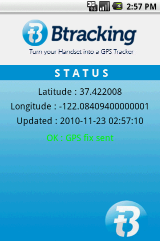
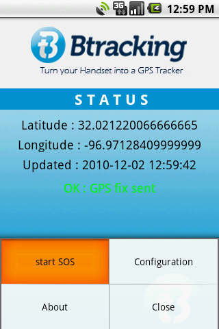
B tracking is a powerful, easy to use GPS based mobile management solution designed for use with the most popular GPS enabled Android Smartphones. The simple application, when downloaded to an employee's device, provides companies with the visibility they need to efficiently manage and monitor your mobile work force and assets from the convenience of their desktop.
With worldwide GPS mapping coverage, customizable alert options, and robust reporting capabilities, B tracking delivers an unparalleled solution to businesses looking to enhance productivity while maximizing their current wireless investment.
Be Better. B tracking.
World wide coverage.
Why Btracking?
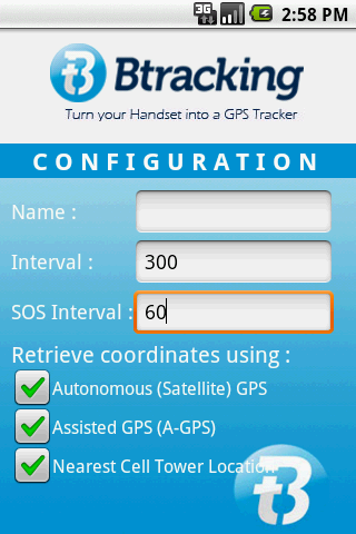
- It's easy to set up and use with an intuitive, web based mapping portal.
- It's powerful:
• Draw 'zones', identify address 'targets' and track world wide
• Receive SMS and or email alerts triggered by location, speed and emergencies
• Generate detailed automated reports daily and access historical reports by user, department and more!
How do you get started?
1. Download the application to your Handset(s)
2. Purchase a license(s) at our site
3. Follow the directions to set up your device(s) to track
4. Start Tracking!
The application download is free. However the access to track online requires a subscription, and can be completed at Btracking(dot)com
Start tracking in minutes!
Like it? Share with your friends!
Supported operating systems:
Google Android 1.5, Google Android 1.6, Google Android 2.0, Google Android 2.1, Google Android 2.2, Google Android 2.3, Google Android 3.0
Similar Software:
GeoPix GeoPix - Headed to work or class? Want your school's mascot or company logo to show up as your wallpaper, "abracadabra" style, just as you arrive? Simply choose an image from Myxer’s massive catalog of wallpapers, or grab one from your phone, set the address- and watch it "auto-magically" appear as you reach your destination
Android FindMyCar Android FindMyCar - Innovative software for Android devices that uses the GPS signal to show signs that allow to reach a geographic location.
Suitable for various uses (eg. find car parked in a parking area or in an unknown city, finding a person (who has sent their coordinates) in a lovely beach, in a fair, in another boat, find an area of sea fishing, etc..)
Maverick Off-road GPS navigator with offline maps support, compass and track recording. Use offline maps and GPS even without an internet connection. This app is great for hiking, boating, geocaching and other outdoor activities
TapIn Places TapIn Places is all about your daily check-in places by tap.
· View nearby places around your location.
· Shared Facebook wall posting.
· Search your favorite places with or without categories simply.
· Manage recent and favorite places.
· Bookmarks your favorite places simply.
· Long click item list to view action detail
Mobile PocketFinder® tm - G1 Mobile PocketFinder® tm - G1 - allows family or friends to see the location of your BlackBerry® phone worldwide from any computer or phone using www.pocketfinder.com. Information like speed, heading, address and altitude can be viewed instantly
Red Panic Button (Android) Red Panic Button - When you are in trouble press the Red Panic Button! You just have to set a panic number and the mobile phone will send a sms which contains a link to Google Maps with your fine GPS based or coarse GSM based coordinates.
What's New in This Release:
· New Feedback button!
· QVGA and WVGA screen layout improvements!
What's New in 2
GPS Essentials Turn your phone into a fully-featured GPS receiver!
GpsTicker Gpsticker is a program for outdoor orientation and navigation with GPS, it is best for hiking and biking. Maps are downloaded automatically from OpenStreetMaps, provided the Phone has an active internet connection
GPS Status GPS Status is an application which displays the information received from the phone's GPS receiver. In addition to the basic location information it can extract and display the state and location of each visible GPS satellite which is displayed on a simple sky view. The outer circle represents the horizon while the center corresponds to the zenith right above your head
DEWA (Android) DEWA - Welcome to the Mobile World of DEWA
Other Software by developer «Herceg Network Inc»:
Btracking Turn your Handset into a GPS Tracker. BerryTracking is a simple API with powerful productivity features. A mobile management system that is based on GPS enabled Blackberry handsets for business or for personal use


")
")


")


")
