GPS Utility - GPS Utility helps you converts between all major geographical coordinate systems.
Helpful for excursionists, navigators users (TomTom, garmin, etc.), GeoCaching lovers, and Bing maps enthusiasts.
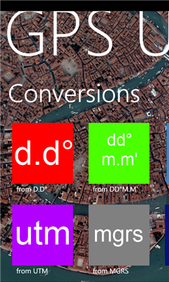
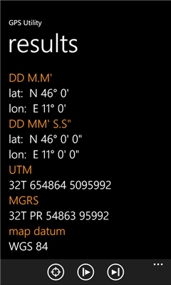
You can convert from and to:
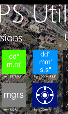
- DMS coordinates (Degrees Minutes Second)
- DM coordinates (Degrees decimal Minutes)
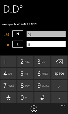
- DD coordinates (decimal Degrees)
- UTM coordinates (Universal Transverse Mercator)
- MGRS coordinates (Military Grid Reference System)
Plus:
- Get your local coordinate in all systems using internal Windows Phone GPS
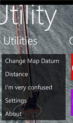
- Get the spherical distance between 2 coordinates
- Built-in Bing Maps view
- References (Wikipedia)
- Real time GPS coordinates
- Km and Miles supported
v1.1:
- add Wikipedia section
- automatic background changer
Like it? Share with your friends!
If you got an error while installing Themes, Software or Games, please, read FAQ.
Supported operating systems:
Windows 10 Mobile, Windows Phone 7, Windows Phone 8
Similar Software:
Jack of Tools Jack of Tools makes your phone into a virtual tool belt. Want to know exactly where you are? Ever wonder how fast that roller coaster ride really is? How high are you? Or maybe you just want to get that desk level
Simple Altimeter Free Simple Altimeter Free - This app answers one simple question: What's my elevation, according to the phone's GPS chip?
Have you ever been hiking, skiing, boarding, or even just driving and wondered what your approximate elevation is? This is the app for you. The best part is that it's free!
Disclaimer: This app is only as accurate as the GPS chip in your phone
GPS Distance GPS Distance - GPS Distance vous permet de calculer rapidement et facilement la distance i vol d'aoiseau qu'il y a entre deux coordonnees GPS.
Les coordonnees sont donnees de facon decimales representant la valeur de l'angle en degre et le resultat est donnee en kilometre
Aide randonnee Aide randonnee - Cette application peut etre tres utile pour vos randonnees, en particulier celles de montagne.
En effet vous pouvez voir la direction vers laquelle le telephone est dirige et vous pouvez aussi voir la hauteur qu'il reste a monter pour atteindre le point culminant de votre randonnee
Speed Phone Speed Phone - SpeedPhone is a GPS application that displays your current speed (mph), altitude (meters) and distance traveled
Coordinate Checker Check the latitude and longitude for a location on the world using this app. Just indicate a location in the world using your finger and the coordinates will be showed
Pocket Cockpit Pocket Cockpit simulates all six basic flight instruments, including airspeed indicator, attitude indicator, altimeter, variometer, turn indicator and heading indicator. It's ideal for aviation enthusiasts, both experienced and amateur, who want to feel like they're flying an airplane even while walking down the street
Quick Speed Free Quick Speed Free is a free speedometer for Windows Phone 7.
It allows you to measure at which speed you are currently traveling based on the GPS locations services.
An elegant, yet simple, car speedometer like gauge is displaying the speed and it also displays the speed in numbers.
It can be set to display either KM/H or MPH
Compass Navigator Compass Navigator is designed to facilitate orientation in the field. The application is useful both in przepyadku lost the road, as well as during the Foot Orienteering.
Compass Navigator will guide you to your destination in a straight line (azimuth and compass). Purpose of the map you can select or enter the latitude and longitude coordinates
Other Software by developer «Dimension Srl»:
Landmeter Landmeter - Call it inclinometer, call it clinometer, call it levels, call it whatever you like ... but you don't have enough of them ... There is still one missing ...
LandMeter is the official inclinometer for all off-roads enthusiasts, 4x4 cars, trucks, jeep, landrover, and trailers