Categories: Business & Profession, Travel & Navigation
Upload date: 18 May 11
Developer: Dimension Srl
License: Freeware
Downloads: 638
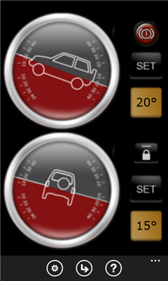
Landmeter - Call it inclinometer, call it clinometer, call it levels, call it whatever you like ... but you don't have enough of them ... There is still one missing ...
LandMeter is the official inclinometer for all off-roads enthusiasts, 4x4 cars, trucks, jeep, landrover, and trailers.
Take control of your car pitching and rolling with your Windows Phone with our dashboard accessory!
---------------
- Landscape or portrait view;
- Separate calibration for pitching and rolling;
- Disable automatic lock of your WP7 (in-car charger suggested);
- Numeric display for accurate pitching and rolling measurement;
- Set an alarm when you reach a certain inclination!
- "Viscosity" features, for a better, realistic and precise movements!
Suggestions or features requests, contact us at iphone@dimension.it
Like it? Share with your friends!
If you got an error while installing Themes, Software or Games, please, read FAQ.
Supported operating systems:
Windows 10 Mobile, Windows Phone 7, Windows Phone 8
Similar Software:
Aide randonnee Aide randonnee - Cette application peut etre tres utile pour vos randonnees, en particulier celles de montagne.
En effet vous pouvez voir la direction vers laquelle le telephone est dirige et vous pouvez aussi voir la hauteur qu'il reste a monter pour atteindre le point culminant de votre randonnee
Compass Free Compass Free application has a GPS compass, Bing maps and waypoints. Helps guide you to home to a car, to a trail head or base camp. Use outside for best results.
Features include:
• GPS Compass
• GPS Accuracy warnings
• Bing Maps
• Waypoints
Please Note:
Compass Free uses GPS triangulation to calculate north
Compass Navigator Compass Navigator is designed to facilitate orientation in the field. The application is useful both in przepyadku lost the road, as well as during the Foot Orienteering.
Compass Navigator will guide you to your destination in a straight line (azimuth and compass). Purpose of the map you can select or enter the latitude and longitude coordinates
Time To Go Time To Go - Time to Go is a simple tool to help you figure out how much time is remaining until you arrive at your destination. Simply put in your current speed and distance remaining (in MPH) and Time to Go will display your remaining time in hours, it's that simple!
Change Log
------------------------------------------------------------------
Version 1.1
Weekend Overdrive Weekend Overdrive shows many useful indicators for passengers on car drive.
Indicators such as compass, clinometer, reverse geo coder, altitude, temperature, twitter helps you recognize your situation
GPS Distance GPS Distance - GPS Distance vous permet de calculer rapidement et facilement la distance i vol d'aoiseau qu'il y a entre deux coordonnees GPS.
Les coordonnees sont donnees de facon decimales representant la valeur de l'angle en degre et le resultat est donnee en kilometre
Coordinate Checker Check the latitude and longitude for a location on the world using this app. Just indicate a location in the world using your finger and the coordinates will be showed
MotoCarma MotoCarma uses GPS on the phone to detect speed, acceleration and location to determine how safely and efficiently you are driving. Acceleration and speeding warnings are displayed on the phone's screen and a chime is played to let you know when you need to adjust your driving behavior
Velocity Lite Velocity Lite - Warns you when you reach a speed limit, and provides you your speed and course.
Upgrade to Velocity full version and you will get history of your speed, distance and altitude and be able to quickly share your location
Geblitzt Geblitzt - Mit diesem Programm konnen Sie in einem perfekt animierten Tacho die gemessene/erlaubte Geschwindigkeit bzw. den Abstand intuitiv eingeben. Das Ergebnis (Geldbuisse, Punkte, Fahrverbot) wird sofort angezeigt. Einfacher geht es nicht.
Besonderheiten:
- Besonders einfache Bedienung.
- Intuitive Eingabe der gemessenen/erlaubten Geschwindigkeit
Other Software by developer «Dimension Srl»:
GPS Utility GPS Utility - GPS Utility helps you converts between all major geographical coordinate systems.
Helpful for excursionists, navigators users (TomTom, garmin, etc.), GeoCaching lovers, and Bing maps enthusiasts