Tube Map - Get round on the London tube like never before! Get LIVE train status updates on a map that you can scroll.
Here are just some of the things the FREE Tube Map app can do to make your life easier and save you time and hassle:
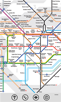
*Tube Map uses the iconic tube map for instant recognition:
- Tap on a station and we will show you the details of the lines and the status of the trains or even show you where the station is on the map - no excuses for being lost or late!
- The map is the very latest releases supplied to us direct from London Underground.
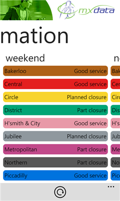
*Line Status LIVE gives you in instant LIVE view of all the basics you need to make sure you don't arrive at the station only to be told there are delays on your line:
- EVERY single line shown in a colour coded easy to recognise list so you can see if there are problems at a glance
- Find out how severe the problem is, if it's only a minor delay at least you know and you don't end up going round the houses to avoid the problem
- See the forecast direct from London Underground of delays they know are around the corner, both later on the day you are looking and even at the weekends
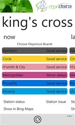
*Departures is the really cool bit that saves you running down the escalator because you can hear a train coming only to find it's not yours:
- You get the information from the little boards on the platform LIVE and directly on your screen to see when the next train leaves/arrives in every direction
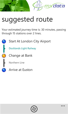
*Journey Planning is normally the frustrating bit but Tube Map takes care of all that by giving you a Journey Planner that puts you in control.
*Find a Station will save you time scanning the 356 stations on the map:
- Enter your station and we will scroll the map to that station and even highlight it for you so straight away you know it is and which line it's on - very handy.
PS. Did we mention that you get all this great stuff completely FREE.
Like it? Share with your friends!
If you got an error while installing Themes, Software or Games, please, read FAQ.
Supported operating systems:
Windows 10 Mobile, Windows Phone 7, Windows Phone 8
Similar Software:
Chicago Maps Chicago Maps - Offline (no data connection necessary!) public transportation maps for the Chicago area. Click on the thumbnails and zoom in for a detailed look.
Includes:
1. an overview of the Chicago Transit Authority system with the ability to zoom into different sections using a map and/or a list
2. Night Owl bus map
Can be used in portrait or landscape view
Vicinity Vicinity automatically locates you and businesses within 1 mile of you, providing 0 click access to everything in your Vicinity. Selecting a search result presents you with a detailed view, including a zoomable map with walking route from your current location
Bing This app helps to use the bing map with just a click
AGMapTime AGMapTime is a simple viewer with time slider features for "time-aware" layer data of ArcGIS services. Time slider lets you browse map features on specific time. You can view various kind of map layers from ArcGIS.com or your own ArcGIS server.
version 0.5 (First version)
- Only supports dynamic layer.
- Fixed base map.
- Slider auto detect time duration
Offline Maps Offline Maps - Want to save money on your data plan and roaming fees abroad? Download maps and use them without having to use an internet connection!
With this application you can download a map of any part in the world and take it with you when travelling
Canada Topography Canada Topography - provides topographic information for the entire country of Canada. The maps provide details such as altitude, railways and numerous other layers. Using the GPS you can center on your current location and even zoom to specific areas of the country.
All maps are provided by Geocratis Canada (http://www.geogratis.gc.ca/geogratis/en/service/toporama
SaraMap SaraMap is a Free Map Application that integrates with Google Map,Microsoft Bing Map and OpenStreetMap.it supports GPS Tracking either.
Main Features:
-Map Navigation with different layers support.
-Using Multi Scale Image control as map viewer core with Multi touch pan/zoom behavior.
-Switch easily between Google Map,Bing Map and OpenStreetMap
-GPS Tracking
ver 1
Wenak Mobisoft Wenak lets you share your location with your friends, family members, co-workers and loved ones by making it easy to tell them where you are and see each other on the map.
Wenak lets you share your location in the background, even when the app is closed
Puget Sound Traffic Puget Sound Traffic is a simple and quick way to view traffic conditions in the Puget Sound area.
Maps are fetched from the Washington State Department of Transportation as well as other sites for Seattle, Bellevue, Tacoma, Olympia, Bellingham and the US/Canada border. Recent incidents from the WSDOT area also displayed.
Maps are not interactive
Other Software by developer «mxData Ltd.»:
Tube Map for BlackBerry Playbook Tube Map forBlackBerry® PlayBookTM will help you plan your journey through the London tube network. It has options to travel by fastest route or fewest changes and will give information on which lines and stations to use, where to change and any walking legs of your journey
GoCommute GoCommute - *** Please note that GoCommute is currently only available for Orange UK pay monthly and pay as you go customers. ***
GoCommute is everything the UK commuter needs to get ahead of the queues. Combining road, rail and air data from leading suppliers, GoCommute from mxData focuses travel alerts into a handy mobile package

")