Categories: Business & Profession, Travel & Navigation
Upload date: 18 May 11
Developer: Dimension Srl
License: Freeware
Downloads: 638
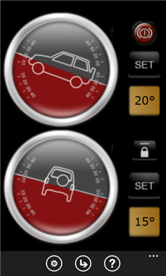
Landmeter - Call it inclinometer, call it clinometer, call it levels, call it whatever you like ... but you don't have enough of them ... There is still one missing ...
LandMeter is the official inclinometer for all off-roads enthusiasts, 4x4 cars, trucks, jeep, landrover, and trailers.
Take control of your car pitching and rolling with your Windows Phone with our dashboard accessory!
---------------
- Landscape or portrait view;
- Separate calibration for pitching and rolling;
- Disable automatic lock of your WP7 (in-car charger suggested);
- Numeric display for accurate pitching and rolling measurement;
- Set an alarm when you reach a certain inclination!
- "Viscosity" features, for a better, realistic and precise movements!
Suggestions or features requests, contact us at iphone@dimension.it
Like it? Share with your friends!
If you got an error while installing Themes, Software or Games, please, read FAQ.
Supported operating systems:
Windows 10 Mobile, Windows Phone 7, Windows Phone 8
Similar Software:
GPS Utility GPS Utility - GPS Utility helps you converts between all major geographical coordinate systems.
Helpful for excursionists, navigators users (TomTom, garmin, etc.), GeoCaching lovers, and Bing maps enthusiasts
Compass Navigator Compass Navigator is designed to facilitate orientation in the field. The application is useful both in przepyadku lost the road, as well as during the Foot Orienteering.
Compass Navigator will guide you to your destination in a straight line (azimuth and compass). Purpose of the map you can select or enter the latitude and longitude coordinates
MotoCarma MotoCarma uses GPS on the phone to detect speed, acceleration and location to determine how safely and efficiently you are driving. Acceleration and speeding warnings are displayed on the phone's screen and a chime is played to let you know when you need to adjust your driving behavior
What's my location What's my location - Looks up and displays your exact location in terms of latitude and longitude. You can then email your location (complete with a google map link) or view your location in bing maps.
Great for saving the location of your parked car or sending your whereabouts to a friend
GPS Distance GPS Distance - GPS Distance vous permet de calculer rapidement et facilement la distance i vol d'aoiseau qu'il y a entre deux coordonnees GPS.
Les coordonnees sont donnees de facon decimales representant la valeur de l'angle en degre et le resultat est donnee en kilometre
Jack of Tools Jack of Tools makes your phone into a virtual tool belt. Want to know exactly where you are? Ever wonder how fast that roller coaster ride really is? How high are you? Or maybe you just want to get that desk level
Compass Free Compass Free application has a GPS compass, Bing maps and waypoints. Helps guide you to home to a car, to a trail head or base camp. Use outside for best results.
Features include:
• GPS Compass
• GPS Accuracy warnings
• Bing Maps
• Waypoints
Please Note:
Compass Free uses GPS triangulation to calculate north
Coordinate Checker Check the latitude and longitude for a location on the world using this app. Just indicate a location in the world using your finger and the coordinates will be showed
Speedometer The Speedometer app is about measuring the speed you are moving and then providing you with the maximum speed you achieved over the time period. It's very useful tool when your kids ask you "what
Other Software by developer «Dimension Srl»:
GPS Utility GPS Utility - GPS Utility helps you converts between all major geographical coordinate systems.
Helpful for excursionists, navigators users (TomTom, garmin, etc.), GeoCaching lovers, and Bing maps enthusiasts

")