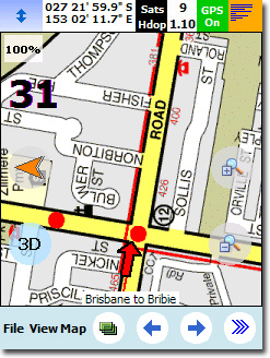
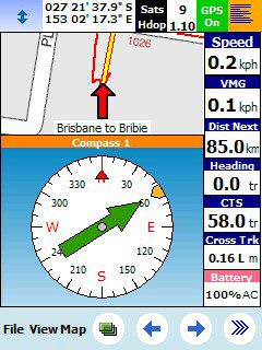
OziExplorerCE - OziExplorerCE is moving map software for mobile devices. It uses raster map images which are either scanned or purchased in digital format. It allows you to track your position received from a GPS on a map (moving map).
OziExplorerCE is not automatic route planning software, you cannot request the best way to get from point A to point B, the types of maps OziExplorerCE uses do not allow this. However OziExplorerCE will allow you to create your own routes on the map and navigate along those.
The design philosophy is you plan your trip using the full PC OziExplorer on you PC and then transfer your waypoints and other data to your PDA for use by OziExplorerCE.
OziExplorerCE runs on PocketPC but it relies on map calibrations, etc to be provided by the full PC version of OziExplorer, in this respect OziExplorerCE can be considered an add-on to the full Oziexplorer software, you also need the full OziExplorer to calibrate maps, plan trips by adding waypoints etc.
· Uses almost any map which can be created by the PC version of OziExplorer.
· Moving map navigation using any GPS providing NMEA output in one of the supported sentences.
· Design the screens used in OziExplorerCE using the PC based designer software.
· Course Up Mode.
· 3D Perspective View Mode.
· Automatic loading of the next map.
· Automatic Route prompting with user created routes (voice and symbol).
· Create Route on screen using the stylus.
· Check for more detailed map at a set interval.
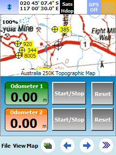
· 5 user tracks can be loaded
· Tracks can be created on the map using the stylus
· Logging of Track points to file.
· Create Waypoint at current position
· Create Waypoints using the Stylus.
· Drag Map Objects to new position.
· Many Map Zoom levels.
· Various Position display formats.
· On screen display of Speed and Bearing.
· Speed Monitor (plays sounds (wav files) when set speeds exceeded).
· Display Waypoints on the map.
· Find Maps at cursor position.
· Name Search
· Log Book
· Satellite View
· Map View
· + much, much more.
· Moving map mode (communication with the GPS) will only remain active for 20 mins each time OziExplorerCE is run and then 10 mins after that (until restarted). At the end of these times a dialog will be displayed and communication will be deactivated.
· A watermark using the text "Demo Version" will be drawn onto the map.
What's New in This Release:
· Added Date and Time format settings - this is under Configuration - Units & Formats.
· Multiple user tracks can be loaded using the TrackLoadList.txt text file.
· Changed date format used in Waypoints comments to stop Chinese characters appearing in some devices.
· Increased the number of parameters which can be used in the Screen Designer.
· Added button in the Screen Designer to create a Man Overboard Waypoint (MOB).
· Added 2 buttons in the Screen Designer to create a Waypoints using the Button Text as part of the Waypoint name.
Like it? Share with your friends!
If you got an error while installing Themes, Software or Games, please, read FAQ.
Map of Wyoming (US State) Map of Wyoming (US State) - A map of the Wyoming by VITO Technology. Good for intercity travels with SmartMap.
SmartMap is a mobile device application which uses vector and raster maps. It is compatible with any NMEA protocol GPS receiver (Compact Flash socket, serial port, BlueTooth or sleeve)
Map of United Arab Emirates Map of United Arab Emirates - A map of United Arab Emirates, divided into 7 smaller territories for the ease of use.
ABU ZABY
DUBAI
ASH SHARIQAH
'AJMAN
UMM AL QAYWAYN
RA'S AL KHAYMAH
AL FUJAYRAH
Good for intercity travels with SmartMap
redBANG Shenzhen Map-Guide NEW 2006 THE BEST MOBILE GRAPHICS YOU HAVE EVER SET YOUR EYES ON
This City map-Guide contains all THE TOP locations at your finger tips. Simple and easy to use, simply zoom in & out of this jpg map or move N, E, S or West
Map of Western Siberia Map of Western Siberia - A map of Western Siberia. Includes following regions:
ALTAYSKIY KRAY
KEMEROVSKAYA OBLAST''
NOVOSIBIRSKAYA OBLAST''
OMSKAYA OBLAST''
RESPUBLIKA ALTAY
TOMSKAYA OBLAST''
Good for intercity travels with SmartMap
Rough Guides Map New York City Rough Guides Map New York City... These guides are a series of fantastic interactive maps.
Produced in conjunction with the premier travel publisher Rough Guides.
Discover and explore New York City using full colour interactive linked maps, in this simple to use PDA version of The Rough Guides New York City
Map of Virginia (US State) Map of Virginia (US State) - A map of the Virginia by VITO Technology. Good for intercity travels with SmartMap.
SmartMap is a mobile device application which uses vector and raster maps. It is compatible with any NMEA protocol GPS receiver (Compact Flash socket, serial port, BlueTooth or sleeve)
Rough Guides Map Amsterdam Rough Guides Map Amsterdam... These guides are a series of fantastic interactive maps.
Produced in conjunction with the premier travel publisher Rough Guides.
Discover and explore Amsterdam using full colour interactive linked maps, in this simple to use PDA version of The Rough Guides Amsterdam
Other Software by developer «oziexplorer.com»:
not found
Comments on OziExplorerCE:
Comments not found
If you noted an error or download link is broken, please, report it via this page or use comments.
OziExplorerCE is compatible with your device Mio 528


")
![USA-IL [Illinois] Map for EagleEye PDA Tracking System](https://static.mobyware.org/data/images/def_program_reduced.png "USA-IL [Illinois] Map for EagleEye PDA Tracking System")
")


")
