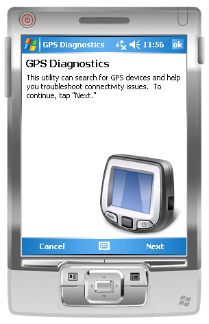
GPS Diagnostics 1.0 - These are the problems which users typically face when they're trying to get their GPS device to work:
1. Users' Windows Mobile 5.0+ devices frequently have incorrect GPS Intermediate Driver settings.
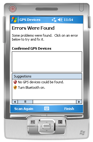
2. Users are unaware that Bluetooth is turned off, or do not know how to configure a virtual serial port for their GPS device.
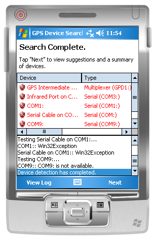
Built using GPS.NET 3.0, the utility will scan the local machine for GPS devices then make suggestions on what could be improved. Suggestions are in clear English and can be clicked to attempt a fix. This utility can:
1. Configure the GPS Intermediate Driver to correct COM: port and baud rate settings.
2. Detect when Microsoft Bluetooth is installed but turned off.
3. Suggest ideal COM: port and baud rate settings to use.
4. Recommend one device as "most reliable" when multiple devices are detected.
5. Generate log files which can (with some tweaking of code) be sent to you for further study.
Like it? Share with your friends!
If you got an error while installing Themes, Software or Games, please, read FAQ.
Supported operating systems:
Windows Mobile 2003, Windows Mobile 5.0, Windows Mobile 6 Classic, Windows Mobile 6 Professional, Windows Mobile 6.1 Classic, Windows Mobile 6.1 Professional, Windows Mobile 6.5 Professional
Similar Software:
chtiGPS chtiGPS is intended to the sportsmen and to hikers, for their training (bicycle, rollers, ski...), but also to locate itself by knowing the distance and the direction from the closest cities. Geolocalization finally makes it possible to reassure its close relations at the time of great exits..
FON Access Points for Belgium FON Access Points for Belgium - FON offers you a new Points of Interest service (POIs). This allows you to download FONspots directly to your navigation device.
What does that mean? You can download a Points of Interest file directly to your navigation device
GPSSateliter GPSSateliter displays the GPS satellite listings and strength as a graph. When you tap the 'Start GPS' button the program will look for GPS satellites and graphically display the decibel of each. The more bars the better your GPS coverage
NaviPOWM NaviPOWM is a car navigation system capable of running on a variety of operating systems. Only OSM based map data is supported. Realtime routing engine is planned in a later version. Geocaching and city guide functionality are also planned
Movmap GPS Movmap is a simple freeware GPS tracking program meant for WinCE/PocketPC machines. It can run on PNAs that use WinCE 4.2 .NET Core OS. See the movmap.txt file for details. Source codes for the program are also available.
The application is now called Movmap3D
MyMotion MyMotion - GPS route recording and playback with customizable spoken feedback of speed, distance and time. Uses a moving map to show progress as well as textual output. Maps can be generated from Google Earth installed on a PC using a map creation tool. Allows user to record a route then load it up as a reference for live comparison the next time it is traversed
GpsPort (Pocket PC) GpsPort (Pocket PC) is a TrekBuddy companion application for WM devices. It redirects COM port to TCP socket. This way TrekBuddy can access internal GPS where Java does not support serial port access (eg. Esmertec Jbed). TrekBuddy uses localhost (127.0.0.1) connection to read the NMEA data
SmartProtect SmartProtect helps you track and recover your phone once stolen or lost.
Features includes:
1. A Thief or Lost Prevention Software with SMS Auto-Responder and GPS Capability created for Windows Mobile Devices.
2
Satsports Log Satsports Log is your general sport app. Ideal for running, cycling, mountain biking, hiking and walking. It also has some fun visual features such as maps and graphs of your elevation, speed and pace. Real time Statistics: Satsports-log has all the stats you could wish
FON Access Points for British Virgin Islands FON Access Points for British Virgin Islands - FON offers you a new Points of Interest service (POIs). This allows you to download FONspots directly to your navigation device.
What does that mean? You can download a Points of Interest file directly to your navigation device
Other Software by developer «Jon Person»:
GPS.NET GPS.NET is a formerly commercial .NET component maintained by GeoFrameworks, LLC from 2004 to 2009. In 2009, Jon Person decided to release the full source code of GPS.NET to the public domain for the benefit of the open source development community. This version (3.0) is the latest release
GeoFramework GeoFramework - This project was formerly a commercial library maintained by the company "GeoFrameworks" for two components it sold (GPS.NET and GIS.NET) from 2004 to 2009. In 2009, Jon Person decided to release the source code for this library in order to assist the open source community


")


