Categories: Business & Profession, Travel & Navigation
Upload date: 14 Jul 10
Developer: Sleuth255
License: Freeware
Downloads: 4098 File Size: 92 Kb
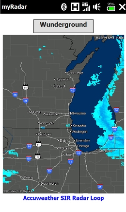
myRadar is a location aware radar application that makes use of Wunderground and Accuweather US web services to show real-time, animated Radar Images of your local area regardless of where in the US you might be. This application requires myLocation services to function automatically.
The program will install to /Program Files/myRadar. A custom png Icon is also located there for those who may wish to install it in Titanium or Manilla. Note: do not install to your SD card.
What's New in This Release:
· Removed the Accuweather feed. Using the Wunderground Feed only. Buttons now allow zoom in/out in 120 mile radius increments.
Like it? Share with your friends!
If you got an error while installing Themes, Software or Games, please, read FAQ.
Supported operating systems:
Pocket PC 2002, Windows Mobile 2003, Windows Mobile 5.0, Windows Mobile 6 Classic, Windows Mobile 6 Professional, Windows Mobile 6.1 Classic, Windows Mobile 6.1 Professional, Windows Mobile 6.5 Professional
Similar Software:
amAze (Motorola) AmAze is a first of its kind free navigation and local search service. It is free to download and use and it contains wide coverage of maps including aerial photo in Europe, North America, Australia and parts of Asia and Africa
e-Mobile GPS Tracker e-Mobile GPS Tracker -
System Requirements
Internet enabled Windows mobile Pocket PC with GPS.
Requires WM5 and WM6 mobile devices
GpsXtended GpsXtended - GpsXtended Xtends the power of GPS. GpsXtended is an easy to use Pocket PC application for field survey and navigation. GpsXtended allows you to navigate with any type of raster map or aerial photography using output from your GPS receiver.
The GPS receivers can connect to the PPC through the serial/data port or bluetooth, CF, SD and PCMCIA slots
FON Access Points for Fiji FON Access Points for Fiji - FON offers you a new Points of Interest service (POIs). This allows you to download FONspots directly to your navigation device.
What does that mean? You can download a Points of Interest file directly to your navigation device
GPSLockerer GPSLockerer keeps your GPS in your device active. When you tap the button the program will start the GPS and download the GPS data for your area. The program keeps the GPS active to allow for quicker fixes when you use another GPS program
MusicGoogler MusicGoogler uses the GPS on your PocketPC to find the 50 closest Music CD and Instrument stores sorted via GPS distance. Tap the button to start the GPS and when you get a lock tap on it to view the list of local stores. You can also dial the store. The GPS maps and store search service is provided by Google
MovieGooglings MovieGooglings uses the GPS on your PocketPC to find the 50 closest movie rental shops sorted via GPS distance. Tap the button to start the GPS and when you get a lock tap on it to view the list of local stores. You can also dial the store. The GPS maps and store search service is provided by Google
GPSPicturer GPSPicture allows you to create GPS stamped JPEG files and displays them in an easy to use explorer interface. When you get a GPS lock the program will display the JPEG files in order of distance to your current GPS. To view the image file simply tap on it. The map service is provided by Google
FON Access Points for Sweden FON Access Points for Sweden - FON offers you a new Points of Interest service (POIs). This allows you to download FONspots directly to your navigation device.
What does that mean? You can download a Points of Interest file directly to your navigation device
GPSSMSerer GPSSMSerer uses the GPS on your PocketPC to find your latitude/longitude/altitude and speed and creates a single blank SMS template. When the program gets its first lock then it creates an SMS with your GPS update location and a link to the Google.com mobile online street map
Other Software by developer «Sleuth255»:
PTTFix PTTFix - this little application replaces the Cingular PTT service and adds customizable launch capabilities back to that useless PTT button on your Cingular ROM equipped Hermes. This patch initially maps the PTT button to the built in Voice Dialer, but you can re-map the push as well as the hold functions to the application of your choice
mySearch mySearch is a location-aware search application that uses Microsoft Bing to return results based on your current position. Just enter in your search term and press the search button to return location specific results!
If your device has HTC's G-Sensor service then simply orient the screen for landscape or portrait mode
myLocation myLocation- It seems like websites and online services are popping up everywhere that can use location to give you more relevant information. Accuweather and others feature location aware weather sites and Google Maps can accept coordinate information to return location aware search results. Of course, with positional awareness comes controversy
ATI ImageON Fix ATI ImageON Fix - This application fixes the ATI ImageON acceleration bug. This is the bug that causes the screen to "tear" during accelerated video playback using CorePlayer, TCPMP or other players that take advantage of the ImageON hardware acceleration. Once this bug is occurring, the entire screen is unreadable until you somehow exit from the video player
SIPChange SIPChange - SIPChange is for those who can no longer change their defaultIM using the reghacks after upgrading to AKU2.x. No matter what you choose, the keyboard SIP is always selected after a soft reset.
If you aren't having this problem, then you don't need this little app


")


