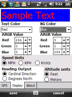
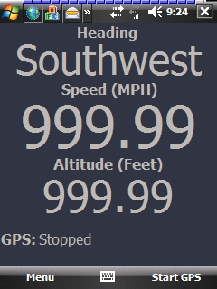
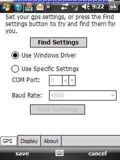
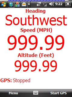
GudenSoft GPS Info An application which shows information from the GPS receiver. It uses both, the Windows Driver, and OpenNETCF's library, so if you have a GPS device, and a Windows Mobile Device, this should work
Like it? Share with your friends!
If you got an error while installing Themes, Software or Games, please, read FAQ.
Supported operating systems:
Windows Mobile 5.0, Windows Mobile 6 Classic, Windows Mobile 6 Professional, Windows Mobile 6.1 Classic, Windows Mobile 6.1 Professional, Windows Mobile 6.5 Professional
Similar Software:
SportsGPSes SportsGPSes - SportsGPSes can be used to view all of the players using the PocketPC SportsGPSer. The program downloads the GPS of all players and displays them on a customized map from Google.com.
This program requires that you have both the 'BeanDLL.dll' file ** and ** the runtime files for Visual Basic on your PocketPC computer
FON Access Points for Dominican Republic FON Access Points for Dominican Republic - FON offers you a new Points of Interest service (POIs). This allows you to download FONspots directly to your navigation device.
What does that mean? You can download a Points of Interest file directly to your navigation device
GPS Tracker GPS Tracker is a part of a fleet management software system, which is used to track mobile phone activity (e.g. mobile phone can be used as a gps tracking device).
The application will monitor the GPS activity and it will send the data to the http://voznipark.virtualniured.hr online server
TrakPal PitStop TrakPal PitStop - Analyse your performance using NMEA compliant GPS data recorded on your Pocket PC - the perfect complement to your GPS navigation software.
Compare data from different runs to find where those important seconds were lost, whether on the track, training, commuting or just for fun
FON Access Points for Colombia FON Access Points for Colombia - FON offers you a new Points of Interest service (POIs). This allows you to download FONspots directly to your navigation device.
What does that mean? You can download a Points of Interest file directly to your navigation device
VITO Navigator II VITO Navigator II-GPS navigation tool for geocaching, hiking and touring to be used without area maps. is our next navigation product, that inherits all advantages of popular VITO Navigator and includes many new features. Elaborated functionality combined with easy-to -use interface gives you unique GPS tool, working fine with the most of GPS receivers
Gippos Gippos is an application for mobile devices allowing the user to locate his or her position on the map, share the location with friends and see other users on the same map. Users can also exchange instant messages with their friends
TextPOIs TextPOIs - TextPOIs can be used to create and edit compact text notes of any length and places the GPS tag at the end of the file. You can view the text files via your current GPS. You can view the text notes via your current GPS distance in real time and edit the text
GPS2day GPS2day is a today screen plug-in showing your current GPS coordinates, speed, satellite info, etc...
Languages: English, Czech, Dutch, French, German, Hungarian, Italian, Japanese, Polish, Russian, Spanish.
Currently GPS2day program works as GPS informer. It supports both metric and U.S
FamilyGPSs FamilyGPSs - FamilyGPSs can be used update your GPS location and track the GPS location of friends/family on your lists. You can view all family members on a map or view each person on a map. The map service is provided by Google.com
This program requires that you have both the 'BeanDLL.dll' file ** and ** the runtime files for Visual Basic on your PocketPC computer
Other Software by developer «GudenSoft»:
Email Scheduler Email Scheduler is a simple service program for Windows Mobile Devices that will automatically change your email polling settings. This means that just like ActiveSync, you can now have a schedule for all of your email accounts to check for messages
Email Scheduler Email Scheduler is a simple service program for Windows Mobile devices that will automatically change your email polling settings. This means that just like ActiveSync, you can now have a schedule for all of your email accounts to check for messages
RadarLove! RadarLove is a simple Radar image engine that pulls all the image data from the National Weather Service RIDGE system, including most of the overlays.
A few pointers:
* you can click on a location, and it will zoom in on that location. When you do this, the map must not move, otherwise the zoom will not work