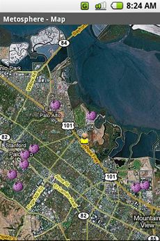
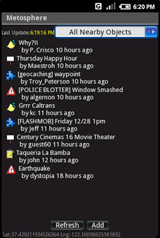
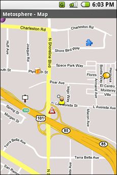
Metosphere Explore and create virtual objects around your physical location like messages, emergency alerts, events, news, reviews, games. View geospatial data from Wikipedia, Eventful, and Upcoming. Start a GeoBlog on your GPS-enabled phone.
This is the core Metosphere Android app. The goal is to follow the Firefox/Eclipse model and provide the ability to create extensions and add-ons like a Geocaching Assistant, Location Messaging Client, Proximity-based KML/GeoRSS Reader, Flash Mob Communicator, Community/Campus Emergency Alert Notifier, or even a Meatspace MUD game.
Like it? Share with your friends!
Supported operating systems:
Google Android 1.0, Google Android 1.5, Google Android 1.6, Google Android 10.x, Google Android 2.0, Google Android 2.1, Google Android 2.2, Google Android 2.3, Google Android 3.0, Google Android 3.1, Google Android 3.2, Google Android 4.0, Google Android 4.1, Google Android 4.2, Google Android 4.3, Google Android 4.4, Google Android 5.x, Google Android 6.x, Google Android 7.x, Google Android 8.x, Google Android 9.x
Back2It Back2It is not just a car locator.
With one click, you may mark places like:
- parking lots
- favorite restaurants
- museums
- theaters
- public park
...
and 1 click to go back with GPS navigation on Google Map.
Switch to Google Map for route
Wireless Info Wireless Info - Want to know more of your GPS, Phone, Wifi and Bluetooth facility. This application will display data like wifi freq, signal strength, no of satellites, bluetooth devices in vicinity etc
wheredroid wheredroid is a simple application to display your coordinates from the GPS receiver: latitude, longitude, heading, speed, number of satellites used and (it's its peculiarity) altitude and accuracy. It is quite usable as an altimeter and a compass.
What's New in This Release:
· fixes a bug inverting East with West on some displays
What's New in 1.4
LAS MobileTracker LT LAS MobileTracker LT - The LAS MobileTracker LT is an easily configured app to read GPS coordinates from an Android OS phone or tablet. Every five minutes, the coordinates and user ID are uploaded to our website from anywhere on the planet that has internet access. A GeoTag button also takes a ''snapshot'' of your location
GPS Assistant GPS Assistant - GPS Assistant is a simple and intuitive app which shows location data from the GPS receiver. You can check your coordinates (latitude and longitude) and altitude. Additionally, it includes a speedometer.
What's New in This Release:
· Changed ad network
What's New in 1
MySpeed MySpeed will record your speed and location to a log file and show it on a map.
It can use a database of speed camera locations to alert you when you're near a speed camera.
There is no speed camera database included. You'll need to download the data from a site such as scdb.info, flitspaal.nl, pocketgpsworld.com, maparadar.com, etc
meet-me FREE meet-me With only a few fingertips you can find your friends in the biggest crowd. Their location is presented by a stylish arrow and distance. Awesome: the positions are dynamically updated
ParkLeitSystem ParkLeitSystem is a car-park-routing system. It shows you, according to your GPS position, the nearest city with a car-park-routing system and gives you a list with all available car-parkings and shows how many free places there are. With a click on the parking it switches to google maps and shows you the position of the parking
VGPS (Vietnamese GPS) for Android VGPS was designed to use city street map on your ordinary mobile phone without the need of having GPS receiver or internet connection. VGPS does not require internal or external GPS receiver. However, if you have internal GPS receiver or external bluetooth GPS receiver, VGPS can work with your GPS receiver as well
Other Software by developer «metosphere.com»:
not found
Comments on Metosphere (Android):
Comments not found
If you noted an error or download link is broken, please, report it via this page or use comments.
Metosphere (Android) is compatible with your device Motorola ZN4 Android


")
")


 for Android")