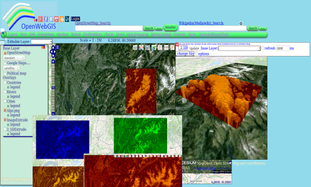
OpenWebGIS - OpenWebGIS is created for everyone who wishes to see and use a new free&open Geographic Information System(GIS). Please make your comments and suggestions. In this GIS you can use the extensive mathematical functionality to calculate and analyze your data. Using OpenWebGIS you will get a GIS at your disposal, it may be similar in functionality to some desktop GIS. Please support this project. The OpenWebGIS for Android has online and local version. In local version, you can use OpenWebGIS without having to connect to the server of OpenWebGIS and even without Internet connection. In local version, some functions do not work, but in future there will be the modification of these functions for the local version. The OpenWebGIS blog (http://openwebgisystem.blogspot.com/) provide a lot of information about possibilities for users' data operating. Full list of articles about OpenWebGIS: http://openwebgisystem.blogspot.com/2015/08/list-of-articles-about-openwebgis-in.html
Like it? Share with your friends!
Supported operating systems:
Google Android 10.x, Google Android 3.0, Google Android 3.1, Google Android 3.2, Google Android 4.0, Google Android 4.1, Google Android 4.2, Google Android 4.3, Google Android 4.4, Google Android 5.x, Google Android 6.x, Google Android 7.x, Google Android 8.x, Google Android 9.x
Similar Software:
Learn C Snipz Learn C Snipz - Its is self learning C Programming App..which caters the need of C program learning beginners..
Its as best programs list..which takes learns with syntatic structure,logic of programs and with sample output.
AChartEngine AChartEngine is a charting library for Android applications
Add-on Compatibility Reporter Add-on Compatibility Reporter - Help Mozilla make sure your favorite add-ons get updated for upcoming Firefox releases by using this extension to report whether they still work or are having some issues with alpha and beta releases
Android Web Editor PRO Android Web Editor PRO is a unique mobile software for web developing. It allows you to create your own html, php, javascript and other pages or edit already existing. You can preview them in web browser via our web-server or in built-in quick view unit. Also you can manage, upload and download files through the FTP as well as managing your local files and folders
Software Engineering v2 Software Engineering v2 - This tutorial is designed for the readers pursuing education in software development domain, Software Testing aspirants and all enthusiastic readers. Software engineering is an engineering branch associated with development of software product using well-defined scientific principles, methods and procedures
Basic concepts of oops Basic concepts of oops - It is an audio podcast tutorials for object oriented programming
1.It teaches features of object oreinted programming
2.It is fully viva based
3
Developers Best Practices Developers Best Practices - If you are working for software industry as a software engineer or a software developer, then I'm sure you are going to enjoy this tutorial. Try to relate the facts mentioned in the tutorial with your day-2-day life and find so many hidden facts, which are very obvious but we never gave our serious attention to them
M32 M32 Did you ever try to learn Assembly? Modern CPUs are far too complex for beginners to learn the basic concepts behind assembly language. M32 simulates a simple CPU and lets you see what your code does: step-by-step
Comments on OpenWebGIS:
Comments not found
If you noted an error or download link is broken, please, report it via this page or use comments.
OpenWebGIS is compatible with your device Navon Predator 7 Tablet