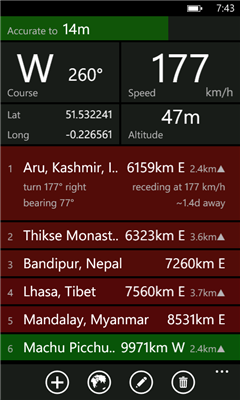
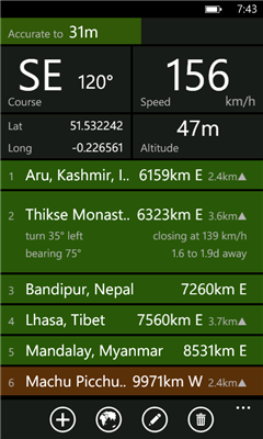
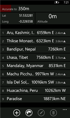
Distant tells you where places are in relation to where you are now. It lists your places in order of distance, and colour codes them so that it is easy to tell at a glance whether you are getting closer or further away. It also tells you how long it will take to get there if you keep moving at the current speed. Places can be entered visually using Bing Maps or directly by entering GPS co-ordinates.
Ever been on a long bus ride and wondered whether there are minutes or hours to go until you reach your destination? Ever had to negotiate with a cab driver who claimed that your destination was "very far away"? Once you got into the cab, did you wonder whether it was going in the right direction at all? Add a waypoint that represents your destination and track your progress in real time.
Going somewhere where you don't have mobile internet access or there is no coverage? Preload your waypoints while you still have access. Once this is done the app no longer requires data or even a signal. It works fine as long as you have a clear view of the sky and can get a GPS fix.
You can also use it to keep track of where you parked your car ...
Like it? Share with your friends!
If you got an error while installing Themes, Software or Games, please, read FAQ.
Supported operating systems:
Windows 10 Mobile, Windows Phone 7, Windows Phone 8
Similar Software:
JaefreyGPS Lite JaefreyGPS Lite This application enables you to view your current position and course. Furthermore you can record a track while walking or driving and upload this track as kml-file to your Dropbox account
FSX Viewer FSX Viewer you can track your current flight on Microsoft Flight Simulator X. Start FSX Tracer on your desktop PC and follow your aircraft on your WP7 device using a detailed Bing map! Stay updated with your longitude, latitude, speed and others fundamental flight parameters. A must-have for all flight simmers!
Version 1
Mount Rainier National Park Mount Rainier National Park - Shows your location on the national park map. This app does not require a cellular or wireless connectivity, so it works in areas that don't have any network. It displays a map of the national park, with your GPS location on it
GPSText GPSText lets you see your GPS location and lets you send that location via text to your friends at the touch of a button
TrackUrSelf This application only tracks the location and displays it on the viewer
Where Am I This application allows to create check point with gps position and (in future release) upload to a community server, to track my movements and find my friends
My Footprints My Footprints helps you save your current location information so that you can reference the information later or share the information with friends
GPS Distance GPS Distance - GPS Distance vous permet de calculer rapidement et facilement la distance i vol d'aoiseau qu'il y a entre deux coordonnees GPS.
Les coordonnees sont donnees de facon decimales representant la valeur de l'angle en degre et le resultat est donnee en kilometre
YP Yellow Pages YP Yellow Pages - Need a cup of coffee, want to find a good pizza place in town? Like to read reviews before choosing a restaurant? The YP app is your easy-to-use guide for local info near you. Search. Find
Other Software by developer «dixiak»:
not found
Comments on Distant:
Comments not found
If you noted an error or download link is broken, please, report it via this page or use comments.
Distant is compatible with your device NGM Harley-Davidson