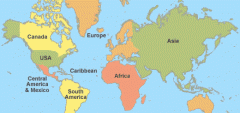
MobileWorldMap - This application can display map-tiles. Colour map-tiles with 128x128 pixel for multiple resolutions (a multi-resolution pyramid) are used to allow fast zooming. This example displays a political world map.
Like it? Share with your friends!
Supported operating systems:
Java ME, Java Nokia 240x320, Java SE 240x320
Similar Software:
DJK EuroMap DJK EuroMap - DJK EuroMap contains the map of Europe (countries, cities)
GpsMid Finland GpsMid is a free, fully offline, vector based map application for your mobile phone. It displays your current position on a zoomable map and can be used to search for and navigate to roads or points of interest of your liking. As all data is stored in a compact binary format on your mobile phone you will incur no charges for extra data downloads
GpsMid Poland GpsMid is a free, fully offline, vector based map application for your mobile phone. It displays your current position on a zoomable map and can be used to search for and navigate to roads or points of interest of your liking. As all data is stored in a compact binary format on your mobile phone you will incur no charges for extra data downloads
GpsMid Kosovo GpsMid is a free, fully offline, vector based map application for your mobile phone. It displays your current position on a zoomable map and can be used to search for and navigate to roads or points of interest of your liking. As all data is stored in a compact binary format on your mobile phone you will incur no charges for extra data downloads
Barcelona DK Eyewitness Top 10 Travel Guide & Map (Java) Barcelona DK Eyewitness Top 10 Travel Guide & Map (Java) - From Gaudi's mind-boggling buildings to the Gothic Quarter, your holiday to Barcelona starts the moment you open the guide, plus Barcelona maps and metro maps.
Discover unmissable museums and galleries, walks and itineraries, fascinating modernist buildings and best tapas to suit every budget and much more
GpsMid Mexico GpsMid is a free, fully offline, vector based map application for your mobile phone. It displays your current position on a zoomable map and can be used to search for and navigate to roads or points of interest of your liking. As all data is stored in a compact binary format on your mobile phone you will incur no charges for extra data downloads
Maps Navigator pro Nav4All 7.0 integrates Navigation, Tracking & Tracing and Myworld in one product. It works worldwide on your own mobile phone in North America, Brasil, Mexico, Europe, Australia and soon in China as well. FOR YOU, FOR FREE You'll never lose your way again and you'll always know where you and your friends are located
Prague DK Eyewitness Top 10 Travel Guide & Map (Java) Prague DK Eyewitness Top 10 Travel Guide & Map (Java) - From Prague castle to the New Town - the 10 best of everything to see, buy, do, taste and avoid in Prague, plus maps and a Metro map
google maps 3.0 google maps 3.0 - My Location (beta)
Google Maps for mobile features My Location, a service that allows you to retrieve your current location without the need for GPS. My Location approximates your current location on the map, usually within 1000 meters, by recognizing information broadcast from mobile towers, and in some cases Wi-Fi signals, near you
GpsMid Nuernberg GpsMid Nuernberg is a free, fully offline, vector based map application for your mobile phone. It displays your current position on a zoomable map and can be used to search for and navigate to roads or points of interest of your liking. As all data is stored in a compact binary format on your mobile phone you will incur no charges for extra data downloads
Comments on MobileWorldMap:
Comments not found
If you noted an error or download link is broken, please, report it via this page or use comments.
MobileWorldMap is compatible with your device Nokai 6500 Classic


")


")

