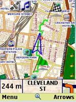
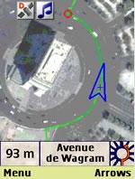
amAze (FLY) - amAze is a first of its kind free navigation and local search service. It is free to download and use and it contains wide coverage of maps including aerial photo in Europe, North America, Australia and parts of Asia and Africa.
With amAze you get all these options and more:
* Visual and voice guidance to any destination
* Search or define any location by its address
* Search and navigate to businesses listed in local search directories (where available)
* Present any required location on the map
* View and use dynamic high quality maps at various scales
* View and navigate over high resolution satellite images
* Calculate the fastest way between two locations
* Save and manage personal favorites list
* Worldwide weather
amAze enables to calculate the route of a journey to any address or point of interest. Bluetooth connection with a GPS receiver will indicate your location along the route with vocal and graphical guidance to your destination in the shortest possible way. amAze is a collaborative effort led by LocatioNet Systems Ltd., together with some leading vendors in the fields of mapping, local search directories and other geographically related content.
Like it? Share with your friends!
Supported operating systems:
Java ME, Java Nokia 240x320, Java SE 240x320
GpsMid Finland GpsMid is a free, fully offline, vector based map application for your mobile phone. It displays your current position on a zoomable map and can be used to search for and navigate to roads or points of interest of your liking. As all data is stored in a compact binary format on your mobile phone you will incur no charges for extra data downloads
Mobile Trail Explorer Mobile Trail Explorer is an application where user can view and record tracks using the mobile phone and GPS device. Recorded tracks can be exported in KML or GPX formats so that they can be viewed in Google Earth application. Mobile Trail Explorer is mainly targeted for recording biking, hiking etc. trails
GpsMid Deutschland (Schleswig Holstein) GpsMid Deutschland (Schleswig Holstein) is a free, fully offline, vector based map application for your mobile phone. It displays your current position on a zoomable map and can be used to search for and navigate to roads or points of interest of your liking
Nav4All Nav4All
For our latest version, open http://www.nav4all.com on your phone in the web browser.
Nav4All is a free GPS navigation tool for your mobile phone. With Nav4All you will never lose your way again and always have access to the most up-to-date information
BlimpMe BlimpMe - See points of interest around you, their real-time adverts and your friends. Follow your friends real-time on the map and on street view. Move with street view real-time and discover points of interest and interesting adverts around you
Street Smart Street Smart - AskLaila StreetSmart is a local search mobile client, using location based service, with a whole lot of goodies built in, like maps and more. This provides context based local search info for more than 6 major cities in India with many more cities in pipeline
GpsMid South Korea GpsMid is a free, fully offline, vector based map application for your mobile phone. It displays your current position on a zoomable map and can be used to search for and navigate to roads or points of interest of your liking. As all data is stored in a compact binary format on your mobile phone you will incur no charges for extra data downloads
FON Access Points for Russian Federation FON Access Points for Russian Federation - FON offers you a new Points of Interest service (POIs). This allows you to download FONspots directly to your navigation device.
What does that mean? You can download a Points of Interest file directly to your navigation device
VGPS (Vietnamese GPS) VGPS (Vietnamese GPS) - was designed to use city street map on your ordinary mobile phone without the need of having GPS receiver or internet connection. VGPS does not require internal or external GPS receiver. However, if you have internal GPS receiver or external bluetooth GPS receiver, VGPS can work with your GPS receiver as well
Other Software by developer «LocatioNet Systems Ltd.»:
amAze (Motorola) AmAze is a first of its kind free navigation and local search service. It is free to download and use and it contains wide coverage of maps including aerial photo in Europe, North America, Australia and parts of Asia and Africa
amAze (Samsung) AmAze is a first of its kind free navigation and local search service. It is free to download and use and it contains wide coverage of maps including aerial photo in Europe, North America, Australia and parts of Asia and Africa
amAze (Sony Ericsson) AmAze is a first of its kind free navigation and local search service. It is free to download and use and it contains wide coverage of maps including aerial photo in Europe, North America, Australia and parts of Asia and Africa
amAze (LG) AmAze is a first of its kind free navigation and local search service. It is free to download and use and it contains wide coverage of maps including aerial photo in Europe, North America, Australia and parts of Asia and Africa
amAze (Samsung) AmAze is a first of its kind free navigation and local search service. It is free to download and use and it contains wide coverage of maps including aerial photo in Europe, North America, Australia and parts of Asia and Africa
amAze GPS (iPhone/iPad) amAze GPS includes turn-by-turn voice guided navigation with worldwide street maps, full topographic map coverage of the USA and satellite imagery for 200 major cities around the world. Initial download includes a free license to view maps and search for POI around the world
amAze (Nokia) AmAze is a first of its kind free navigation and local search service. It is free to download and use and it contains wide coverage of maps including aerial photo in Europe, North America, Australia and parts of Asia and Africa
amAze (Android) AmAze is a first of its kind free navigation and local search service. It is free to download and use and it contains wide coverage of maps including aerial photo in Europe, North America, Australia and parts of Asia and Africa
amAze (Philips) First of its kind free navigation and local search service. It is free to download and use and it contains wide coverage of maps including aerial photo in Europe, North America, Australia and parts of Asia and Africa


")
")


")


")
")
")
")
")
")
")
")
")
")