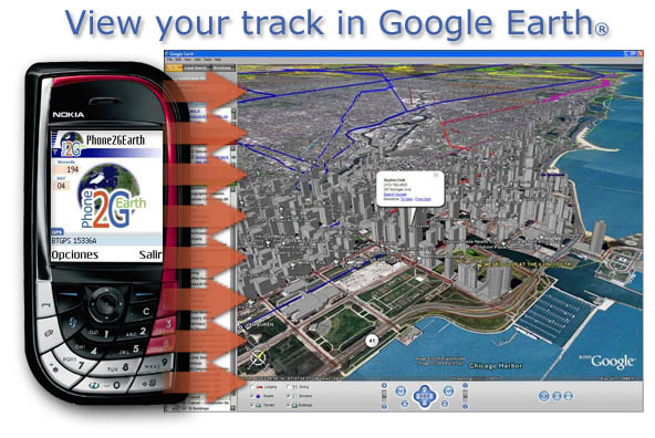
Phone2GEarth S60 converts GPS data directly to Google Earth® KML files.
Phone2Gearth is an easy Nokia Series 60 GPS aplication that allows to log tracks which are directly saved as Google Earth KML files.
New and usefull features like (Version 1.08):
- English, Spanish, German and French languages.
- Placemarks supported with timestamps in the track.
- bluetooth autostart, for easy use.
- Complete Series 60 supported. New models included. N90, 6680, 6670, 3230.. etc.
- Color and phone name configurable. it allows deference phones, tracks etc.
Easy 4-step Process
Set GPS Bluetooth:
In the Settings Menu you can choose "Set GPS", you will find the GPS automatically. If you use Bluetooth GPS, it might be necessary to activate Bluetooth before clicking "Set GPS".
Start capture LOG:
After having selected the GPS, click "Start" and your paths are used to log tracks.. On the top of the screen you can see the number of records and the number of satellites fixed. Select "Stop" for stoping the logged.
Export to Google Earth:
The Export menu allows choosing the destination (via bluetooth or via file) and generate the KML file.
View your Track in Google Earth:
You have to transfer the file to your PC. By double clicking the KML file, Google Earth opens and displays the track.
Like it? Share with your friends!
If you got an error while installing Themes, Software or Games, please, read FAQ.
Speereo Voice Translator: English-Turkish (s60v2) Speereo Voice Translator (SVT) is an ideal companion for traveling on business or leisure and also is an excellent aid for business communication. Running on Windows Mobile and Symbian based mobile devices it contains of over 4000 phrases in each of 16+ languages and many other useful features
Map of Senegal Map of Senegal - A map of Senegal. Good for intercity travels with SmartMap.
Layers include:
Towns
Settlements
Airports
Roads
Railroads
Rivers
Inland water
Administrative borders
International borders
Trees
Map scale is 1:1 million.
Good for use with any version of SmartMap. SmartMap can be purchased here
Travel Hamburg, Germany - Illustrated Guide, Phrasebook and Maps Travel Hamburg, Germany - Illustrated Guide, Phrasebook and Maps- An illustrated city guide, phrasebook, and maps. Indulge Yourself with a personal tour guide on Your PDA. FREE General chapter, basic phrasebook, and a map in the trial version.
Features
Fully illustrated.
Historical overviews.
Interesting facts
Map of Wyoming (US State) Map of Wyoming (US State) - A map of the Wyoming by VITO Technology. Good for intercity travels with SmartMap.
SmartMap is a mobile device application which uses vector and raster maps. It is compatible with any NMEA protocol GPS receiver (Compact Flash socket, serial port, BlueTooth or sleeve)
Map of Turkey Map of Turkey - A map of Turkey, divided into 67 smaller territories for the ease of use. Good for intercity travels with SmartMap.
Layers include:
Towns
Settlements
Airports
Roads
Railroads
Rivers
Inland water
Administrative borders
International borders
Trees
Map scale is 1:1 million
Map of Sri Lanka Map of Sri Lanka - A map of Sri Lanka. Good for intercity travels with SmartMap.
Layers include:
Towns
Settlements
Airports
Roads
Railroads
Rivers
Inland water
Administrative borders
International borders
Trees
Map scale is 1:1 million.
Good for use with any version of SmartMap. SmartMap can be purchased here
Travel Vienna, Austria - illustrated city guide, phrasebook, and maps Travel Vienna, Austria - illustrated city guide, phrasebook, and maps. Indulge Yourself with a personal tour guide on Your PDA. FREE General Information chapter, basic phrasebook and a map in the trial version.
Features
Fully illustrated.
Historical overviews.
Interesting facts.
Street Map, Metro Map, and more.
Museums hours and ticket info
Travel Acadia National Park - illustrated travel guide and maps Travel Acadia National Park - illustrated travel guide and maps- is a comprehensive travel guide illustrated with maps and photographs. Indulge Yourself with a personal tour guide on Your PDA. FREE General Information chapter and a map in the trial version.
Features
Fully illustrated.
Geology, Flora, Fauna and more.
Interesting facts.
Maps
Map of Pakistan Map of Pakistan - A map of Pakistan. Good for intercity travels with SmartMap.
Layers include:
Towns
Settlements
Airports
Roads
Railroads
Rivers
Inland water
Administrative borders
International borders
Trees
Map scale is 1:1 million.
Good for use with any version of SmartMap. SmartMap can be purchased here
Map of Slovakia Map of Slovakia - A map of Slovakia, divided into 4 smaller territories for the ease of use.
BRATISLAVA
ZAPADOSLOVENSKY
STREDOSLOVENSKY
VYCHODOSLOVENSKY
Good for intercity travels with SmartMap
Other Software by developer «CYMONLINE»:
Phone2GEarth S80 Phone2GEarth S80 converts GPS data directly to Google Earth® KML files.
Phone2Gearth is an easy Nokia Series 80 GPS aplication that allows to log tracks which are directly saved as Google Earth KML files.
New and usefull features like (Version 1.08):
- English, Spanish, German and French languages.
- Placemarks supported with timestamps in the track
REALTRACK MOBILE POCKETPC Fleet Management and mobile devices tracking Comprehensive System, which allow the user to remotely track any person or object carrying a mobile device of the PDA


_programView.jpg)
")


")


