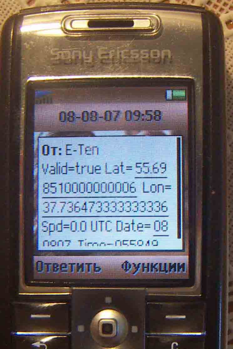
GPSbySMS (Java) - GPSbySMS reads data from the GPS receiver and sends it to the http://gps.ndd.ru site, or to other users using SMS messages. You can see your position on Yahoo Map. Auto send Mode available now.
Tested on: Sony Ericsson K6xx, K7xx, K8xx, W8xx series and Nokia 6151, 6288, 6300i.
Like it? Share with your friends!
Requirements:External Bluetooth or internal GPS receiver (NMEA GPS Message format) and Cellular phone with Bluetooth and Java;
MIDP 2.0 (JSR 118);
CLDC 1.0 (JSR 139);
Java API for Bluetooth (JSR 82);
Wireless Messaging API (JSR 120);
Phone Book Manager API (JSR-75);
Multi Media API (JSR-135)
Supported operating systems:
Java ME, Java Nokia 240x320, Java SE 240x320
Similar Software:
Around(J2)ME Around(J2)ME is a location-based mobile application that uses the phone's current location in order to provide all nearby places that are either belonging to a pre-de fined category (e.g. banks, bars, pubs, restaurants, taxis, theaters, parking) or that match a certain search criteria (e.g. name, description, address)
GpsMid Ontario GpsMid Ontario is a free, fully offline, vector based map application for your mobile phone. It displays your current position on a zoomable map and can be used to search for and navigate to roads or points of interest of your liking. As all data is stored in a compact binary format on your mobile phone you will incur no charges for extra data downloads
Pinkr 20090928 Pinkr is a RESTful client for a GPS tracking system designed to work on a mobile phone that supports J2ME.
GPS data are collected from a bluetooth-connected or a built-in device and pushed to a RESTful web service over HTTP protocol
Map My Tracks Map My Tracks - Map My Tracks turns your mobile phone into your personal training device that tracks your activities in real-time to share with others online. Map My Tracks is great for bringing a new insight into your sporting activity, it provides a competitive edge and makes training fun. Map My Tracks let your friends, competitors or parents know where you are right now
amAze (Philips) First of its kind free navigation and local search service. It is free to download and use and it contains wide coverage of maps including aerial photo in Europe, North America, Australia and parts of Asia and Africa
Place Finder West USA Place Finder West USA - A tool for finding places of interest in the vicinity of a location keyword. Once downloaded and installed on your mobile phone you can search (using location keywords or parts of words) to find corresponding Wikipedia Keyword place entries and also nearby entries in the proximity (with the approximate distances indicated in units of 0
GpsMid Singapore GpsMid is a free, fully offline, vector based map application for your mobile phone. It displays your current position on a zoomable map and can be used to search for and navigate to roads or points of interest of your liking. As all data is stored in a compact binary format on your mobile phone you will incur no charges for extra data downloads
FON Access Points for Bangladesh FON Access Points for Bangladesh - FON offers you a new Points of Interest service (POIs). This allows you to download FONspots directly to your navigation device.
What does that mean? You can download a Points of Interest file directly to your navigation device
GpsMid Koeln/Bonn GpsMid Koeln/Bonn is a free, fully offline, vector based map application for your mobile phone. It displays your current position on a zoomable map and can be used to search for and navigate to roads or points of interest of your liking. As all data is stored in a compact binary format on your mobile phone you will incur no charges for extra data downloads
FON Access Points for Mayotte FON Access Points for Mayotte - FON offers you a new Points of Interest service (POIs). This allows you to download FONspots directly to your navigation device.
What does that mean? You can download a Points of Interest file directly to your navigation device
Other Software by developer «Astra-Service»:
GPSbyGPRS (Pocket PC) GPSbyGPRS is a version of GPSbySMS made for Pocket PCs without GSM module
GPSbySMS GPSbySMS is an application that reads navigation data from GPS and sends it to any user via SMS or email.
Purpose:
1) Read navigation data from GPS and send it to any user via SMS or email.
2) View current position on Maps (need Internet connection).
3) Save navigation data in database using data transfer via GPRS Internet
GPSbySMS (Android) GPSbySMS is an application that reads navigation data from GPS and sends it to any user via SMS or email.
Purpose:
1) Read navigation data from GPS and send it to any user via SMS or email.
2) View current position on Maps (need Internet connection).
3) Save navigation data in database using data transfer via GPRS Internet.
4) Alarm Function


")
")
ME")


")


")

")