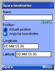
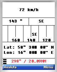
GPS Pal is a Java application that shows speed, direction and position on mobile phones that have a built-in GPS. Primary for use in boat or car, but hiking is fine too.
What's New in This Release:
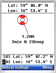
· "Man over board" is implemented. Great for increased security when chilling on water in both small and big boats.
Like it? Share with your friends!
Requirements:Built-in GPS
Supported operating systems:
Java ME, Java Nokia 240x320, Java SE 240x320
Similar Software:
GpsMid Bosnia-Herzegovina GpsMid is a free, fully offline, vector based map application for your mobile phone. It displays your current position on a zoomable map and can be used to search for and navigate to roads or points of interest of your liking. As all data is stored in a compact binary format on your mobile phone you will incur no charges for extra data downloads
Tracking - Transportlines Tracking - Transportlines - Live GPS tracking system - Sign up at www.transportlines.com first to get your account - Free Allows for multiple users under your own account. Keeps, speed, direction, time, address of each reported position. Various reports available. Useful for hikers, cyclists, yachting, keeping track of your employees etc.
GpsMid Bay Area (California) GpsMid is a free, fully offline, vector based map application for your mobile phone. It displays your current position on a zoomable map and can be used to search for and navigate to roads or points of interest of your liking. As all data is stored in a compact binary format on your mobile phone you will incur no charges for extra data downloads
FON Access Points for Israel FON Access Points for Israel - FON offers you a new Points of Interest service (POIs). This allows you to download FONspots directly to your navigation device.
What does that mean? You can download a Points of Interest file directly to your navigation device
GpsMid Amsterdam GpsMid is a free, fully offline, vector based map application for your mobile phone. It displays your current position on a zoomable map and can be used to search for and navigate to roads or points of interest of your liking. As all data is stored in a compact binary format on your mobile phone you will incur no charges for extra data downloads
j2me PhotoGeoTag j2me PhotoGeoTag - Take pictures with your mobile phone and incorporate the data of the geographical location. The application allows you to include in the photographs, data from the GPS receiver, along with a brief note. If you know the coordinates, not having the GPS receiver, you can also handwrite geographic data
FON Access Points for Morocco FON Access Points for Morocco - FON offers you a new Points of Interest service (POIs). This allows you to download FONspots directly to your navigation device.
What does that mean? You can download a Points of Interest file directly to your navigation device
FON Access Points for Vietnam FON Access Points for Vietnam - FON offers you a new Points of Interest service (POIs). This allows you to download FONspots directly to your navigation device.
What does that mean? You can download a Points of Interest file directly to your navigation device
FON Access Points for Puerto Rico FON Access Points for Puerto Rico - FON offers you a new Points of Interest service (POIs). This allows you to download FONspots directly to your navigation device.
What does that mean? You can download a Points of Interest file directly to your navigation device
GpsMid Netherlands GpsMid is a free, fully offline, vector based map application for your mobile phone. It displays your current position on a zoomable map and can be used to search for and navigate to roads or points of interest of your liking. As all data is stored in a compact binary format on your mobile phone you will incur no charges for extra data downloads
Other Software by developer «Gunnar Slott»:
not found
Comments on GPS Pal:
Comments not found
If you noted an error or download link is broken, please, report it via this page or use comments.
GPS Pal is compatible with your device Nokia C2-02 / C2-03 / C2-05


")


