Categories: Internet & Communications, Travel & Navigation
Upload date: 10 Aug 10
Developer: Ulf Arndt
License: Freeware
Downloads: 3651 File Size: 42 Kb
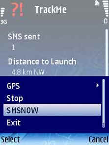
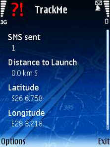
TrackMe (S60)-An application that sends your location at a regular interval via SMS to another cellphone. If it receives a SMS query in a certain format (e.g. from RTMS), will send your location to the predefined number.
Like it? Share with your friends!
If you got an error while installing Themes, Software or Games, please, read FAQ.
FON Access Points for Cambodia FON Access Points for Cambodia - FON offers you a new Points of Interest service (POIs). This allows you to download FONspots directly to your navigation device.
What does that mean? You can download a Points of Interest file directly to your navigation device
FON Access Points for Cape Verde FON Access Points for Cape Verde - FON offers you a new Points of Interest service (POIs). This allows you to download FONspots directly to your navigation device.
What does that mean? You can download a Points of Interest file directly to your navigation device
FON Access Points for Jersey FON Access Points for Jersey - FON offers you a new Points of Interest service (POIs). This allows you to download FONspots directly to your navigation device.
What does that mean? You can download a Points of Interest file directly to your navigation device
Mobiaccess LogistiX (Symbian) Mobiaccess LogistiX (Symbian) - A useful application for people working on the field. Helps the representative to take orders, manage customers, and drive on the road with GPS.
Demo features
LogistiX demo application offers almost all the functions that are essential for an effective field work
FON Access Points for Andorra FON Access Points for Andorra - FON offers you a new Points of Interest service (POIs). This allows you to download FONspots directly to your navigation device.
What does that mean? You can download a Points of Interest file directly to your navigation device
Navizon for Symbian Navizon for Symbian - Navizon is the perfect urban companion for your handheld. It allows you to find cool places around you (such as bars, restaurants etc...), see where your friends are and find your own directions
Users with a GPS device can use Navizon worldwide. And Navizon will allow you to get a GPS fix where you couldn't before (indoors, urban canyons etc..
Aspicore GSM Tracker Makes your phone into a real-time AVL (Automatic Vehicle Location) tracking device. See your track in real time on Google Earth or GpsGate.com! Recover your lost GPS phone!
4squick 4squick is a lite and very fast FourSquare app for Symbian. Basically you are able to check-in to places, see who's there, lookup nearby places and see some stats
AFTrack (S60 3rd Edition) AFTrack (S60 3rd Edition) - AFTrack is the display for your GPS mouse and activates the world of hiking, biking, sailing, geocaching or more for your phone. The program handles tracking with smart and fixed logging features.
It sends reports via GPRS or SMS. It receives SMS position messages and show it as a waypoint. It exports and imports waypoints and routes
FON Access Points for Trinidad and Tobago FON Access Points for Trinidad and Tobago - FON offers you a new Points of Interest service (POIs). This allows you to download FONspots directly to your navigation device.
What does that mean? You can download a Points of Interest file directly to your navigation device
Other Software by developer «Ulf Arndt»:
RTMS RTMS - This JAVA Midlet sends a SMS to a mobile phone that runs the TrackMe code.
It sends an SMS to TrackMe, TrackMe then sends a SMS with the location data to the predefined number.
The predefined number gets set by the enduser when TrackMe gets started.
The code needs a trackmesms.txt file in the Images folder of the cellphone
PRS GPS PRS GPS - Uses a built-in GPS of a Nokia Phone and JAVA J2ME based Location based service to SMS your Pilot Status to the Pilot Recovery System. Can be used for the Winelands Paragliding comp. The JAVA J2ME Midlet feeds via SMS the Pilot Recovery status webpage
Pilot Recovery System Pilot Recovery System - A simple J2ME JAVA Midlet that can be used with the Pilot Recovery System. Can be used for the Winelands Paragliding comp. The JAVA J2ME Midlet feeds via SMS the Pilot Recovery status webpage
TrackMeTweet TrackMeTweet - uses the built-in GPS, or a Bluetooth GPS (recommended for cellphone battery life) to send regular tweets of your location to Twitter.
The Tweet info contains your identifier, distance from take-off in km, coordinates in degrees and decimal minutes, altitude in meters above sea level, speed in km/h, direction you are heading at that specific moment


")
")


")


")


