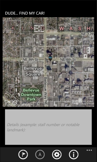
Find My Car Have you every parked your car and then went about your day, only to realize at the end of the day that you don't recall where you parked it? Then "Find My Car" is for you.
What's New in This Release:
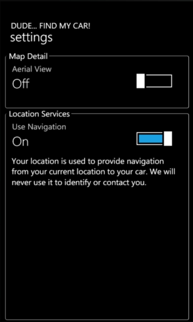
· Updated to support copy and paste functionality and update Bing maps.
· Corrected the loading screen to read “Acquiring location…” instead of “Locating location…”
Like it? Share with your friends!
If you got an error while installing Themes, Software or Games, please, read FAQ.
Supported operating systems:
Windows 10 Mobile, Windows Phone 7, Windows Phone 8
Similar Software:
Free World Explorer Free World Explorer - So, you think you are good at geography? Let's see how good you are :)
Pan the map to fly the plane to the destination place and click on land button when you find the green airport symbol. You need to be connected to internet for this. Difficulty mode to challenge you with a lot more countries
Maps+ Maps+ - Maps Plus (Maps+) is an easy to use, powerful way to find directions, points of interest, locations, and anything else you're looking for
Prague Maps Prague Maps - This app contains offline (no data plan/reception necessary) public transportation maps for the Prague area, including tourist maps, metro/tram maps, and the Airport Express, which takes you from Prague Airport to popular the main train station, Hlavni Nadrazi
Vicinity Vicinity automatically locates you and businesses within 1 mile of you, providing 0 click access to everything in your Vicinity. Selecting a search result presents you with a detailed view, including a zoomable map with walking route from your current location
Transit Maps USA Free Transit Maps USA Free - The only Transit Maps app of its kind. You can select the city you want to see the transit maps for and zoom in to view the map in detail on the full screen. You can easily zoom-in, pan, and zoom-out using one hand only. You can now plan your trip from anywhere, any time - no Internet/data connection required
Canada Topography Canada Topography - provides topographic information for the entire country of Canada. The maps provide details such as altitude, railways and numerous other layers. Using the GPS you can center on your current location and even zoom to specific areas of the country.
All maps are provided by Geocratis Canada (http://www.geogratis.gc.ca/geogratis/en/service/toporama
Puget Sound Traffic Puget Sound Traffic is a simple and quick way to view traffic conditions in the Puget Sound area.
Maps are fetched from the Washington State Department of Transportation as well as other sites for Seattle, Bellevue, Tacoma, Olympia, Bellingham and the US/Canada border. Recent incidents from the WSDOT area also displayed.
Maps are not interactive
NaMap NaMap - The primary text of the application NaMap is in English and Korean.
English Description:
"Namap" application provide map information providing by Naver Open API
Wenak Mobisoft Wenak lets you share your location with your friends, family members, co-workers and loved ones by making it easy to tell them where you are and see each other on the map.
Wenak lets you share your location in the background, even when the app is closed

 / 800c")