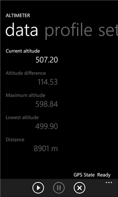
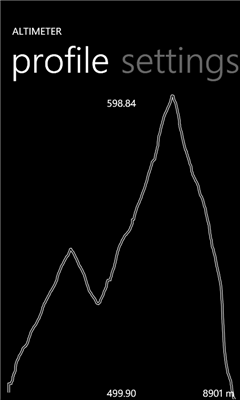
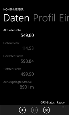
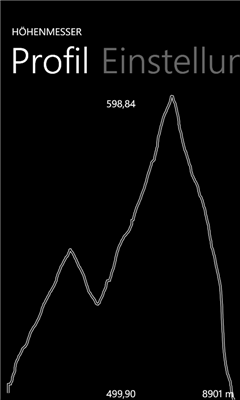
Altitude Difference - Collects the altidude difference of a hike in the mountains.
Like it? Share with your friends!
If you got an error while installing Themes, Software or Games, please, read FAQ.
Supported operating systems:
Windows 10 Mobile, Windows Phone 7, Windows Phone 8
Similar Software:
Jack of Tools Jack of Tools makes your phone into a virtual tool belt. Want to know exactly where you are? Ever wonder how fast that roller coaster ride really is? How high are you? Or maybe you just want to get that desk level
Velocity Lite Velocity Lite - Warns you when you reach a speed limit, and provides you your speed and course.
Upgrade to Velocity full version and you will get history of your speed, distance and altitude and be able to quickly share your location
Quick Speed Free Quick Speed Free is a free speedometer for Windows Phone 7.
It allows you to measure at which speed you are currently traveling based on the GPS locations services.
An elegant, yet simple, car speedometer like gauge is displaying the speed and it also displays the speed in numbers.
It can be set to display either KM/H or MPH
GPSTester GPSTester - Simple GPS application that uses your phone to record your trip's maximum speed, average speed and current speed.
Don't forget that it will also tell you how far you have travelled.
Simple, but fun for all ages
Landmeter Landmeter - Call it inclinometer, call it clinometer, call it levels, call it whatever you like ... but you don't have enough of them ... There is still one missing ...
LandMeter is the official inclinometer for all off-roads enthusiasts, 4x4 cars, trucks, jeep, landrover, and trailers
Compass Free Compass Free application has a GPS compass, Bing maps and waypoints. Helps guide you to home to a car, to a trail head or base camp. Use outside for best results.
Features include:
• GPS Compass
• GPS Accuracy warnings
• Bing Maps
• Waypoints
Please Note:
Compass Free uses GPS triangulation to calculate north
GPS Utility GPS Utility - GPS Utility helps you converts between all major geographical coordinate systems.
Helpful for excursionists, navigators users (TomTom, garmin, etc.), GeoCaching lovers, and Bing maps enthusiasts
FtsMind FtsMind - FtsMind - Die Mind-Map-Applikation fur unterwegs.
Mit Mind-Maps jederzeit Ideen aufzeichnen und strukturieren.
Die Maps werden am Phone erstellt und bearbeitet. Sie konnen per E-Mail zum PC geschickt und danach mit dem Freeware-Programm FreeMind weiterbearbeitet werden

")