Platforms: Symbian OS, Series 60, Series 80, Series 90, UIQ, Java
Categories: Travel & Navigation
Upload date: 3 Dec 10
Developer: Cristian Streng
License: Freeware
Downloads: 1178737 File Size: 197 Kb
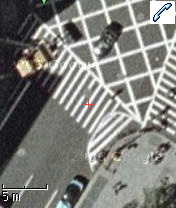
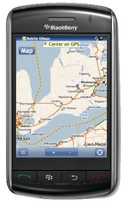
Mobile GMaps is a FREE application that displays maps from various sources like Yahoo! Maps, Windows Live Local, Ask.com and Open Street Map on Symbian and Java J2ME-enabled mobile phones, PDAs and other devices. MGMaps can connect to a GPS receiver over bluetooth or use internal GPS features on some phones in order to automatically display the map for your current position.
Maps and satellite imagery: view various types of maps and aerial images, zoom in and out, mark favorite places with map pushpins.
GPS connectivity: connect to a GPS device over bluetooth or use the internal GPS to view maps or aerial imagery for your current location. Enable GPS synchronization to continuously move the map as you move around, view your position, speed and heading.
Search for places or businesses, view the results including addresses and phone numbers, get step-by-step directions. Do you want to call any of them? You can do that directly from Mobile GMaps!
Favorites: store your favorite places or search results to jump quickly to any of them.
Stored maps:New! pre-download maps on your phone and use them without going online.
GPS tracking:New! see where you are and track your friends on the phone, or on the web site http://www.gmap-track.com .
Traffic info: see the congested roads and estimate delays in major U.S. metropolitan areas.
Subway maps: view subway maps for New York, London, Berlin, Washington DC, Boston, Philadelphia, Chicago.
Mobile Wikimapia: Wikimapia.org is a mashup that allows users to add tags and annotate locations displayed on Google Maps. They already have over 1 million places, now you can view them on your cellphone using MGMaps!
View KML files: view any .kml file available online containing Google Earth places by simply entering its web address. Compressed files (.kmz) are also supported.
Like it? Share with your friends!
If you got an error while installing Themes, Software or Games, please, read FAQ.
Travel Florence, Tuscany, and Umbria Indulge Yourself with a personal tour guide on Your PDA. FREE General Info, a map, and phrasebook in the trial version.
Features
Fully illustrated.
Historical overviews.
Interesting facts.
Street Map, Transportation Maps, and more.
Museums hours and ticket infor.
Navigate from Table of Contents or search for the words or phrases
Travel Paris, France - illustrated city guide, phrasebook, and maps Travel Paris, France - illustrated city guide, phrasebook, and maps- illustrated city guide, phrasebook, and maps. Indulge Yourself with a personal tour guide on Your PDA. FREE General Information chapter, basic phrasebook, and a map in the trial version.
Features
Fully illustrated.
Historical overviews.
Interesting facts
MetrO (S60 1st/2nd Edition) MetrO finds your way in public transport systems in more than 350 cities around the world (Paris, New York, London, Tokyo, any city with a subway & many more!)
Travel Grand Teton National Park - illustrated travel guide and maps Travel Grand Teton National Park - illustrated travel guide and maps- is a comprehensive travel guide illustrated with maps and photographs. Indulge Yourself with a personal tour guide on Your PDA. FREE General Information chapter and a map in the trial version.
Features
Fully illustrated.
Geology, Flora, Fauna and more.
Interesting facts
Map of Vermont (US State) Map of Vermont (US State) - A map of the Vermont by VITO Technology. Good for intercity travels with SmartMap.
SmartMap is a mobile device application which uses vector and raster maps. It is compatible with any NMEA protocol GPS receiver (Compact Flash socket, serial port, BlueTooth or sleeve)
Travel Grand Canyon National Park - illustrated travel guide and maps Travel Grand Canyon National Park - illustrated travel guide and maps is a comprehensive travel guide illustrated with maps and photographs. Indulge Yourself with a personal tour guide on Your PDA. FREE General Information chapter and a map in the trial version.
Features
Fully illustrated.
Geology, Flora, Fauna and more.
Interesting facts.
Map
Travel Milan, Italy - illustrated travel guide, phrasebook, and maps Travel Milan, Italy - illustrated travel guide, phrasebook, and maps-
An illustrated city guide, phrasebook, and maps. Indulge Yourself with a personal tour guide on Your PDA. FREE General Info, basic phrasebook and a map in the trial version.
Features
Fully illustrated.
Historical overviews.
Interesting facts
Map of Vietnam Map of Vietnam - A map of Vietnam.
Good for intercity travels with SmartMap.
Layers include:
Towns
Settlements
Airports
Roads
Railroads
Rivers
Inland water
Administrative borders
International borders
Trees
Map scale is 1:1 million.
Good for use with any version of SmartMap. SmartMap can be purchased here
Travel Washington, DC - illustrated travel guide and maps Travel Washington, DC is a comprehensive travel guide illustrated with maps and photographs. Indulge Yourself with a personal travel guide on Your PDA. FREE General Information chapter and a map in the trial version.
Features
Fully illustrated.
Historical overviews.
Interesting facts.
Maps of Downtown, Metro, and more
Map of North Korea Map of North Korea - A map of North Korea, divided into 11 smaller territories for the ease of use.
HAMGYONG-BUKTO
YANGGANG-DO
CHAGANG-DO
HAMGYONG-NAMDO
P'YONGAN-BUKTO
P'YONGAN-NAMDO
P'YONGANG-SI
HWANGHAE-NAMDO
HWANGHAE-BUKTO
KANGWON-DO
KAESONG-SI
Good for intercity travels with SmartMap
Other Software by developer «Cristian Streng»:
Mobile GMaps Mobile GMaps is a FREE application that displays maps from various sources like Yahoo! Maps, Windows Live Local, Ask.com and Open Street Map on Java J2ME-enabled mobile phones, PDAs and other devices. MGMaps can connect to a GPS receiver over bluetooth or use internal GPS features on some phones in order to automatically display the map for your current position
Mobile GMaps Mobile GMaps is a FREE application that displays Google Maps, Yahoo! Maps, Windows Live Local (MSN Virtual Earth) and Ask.com Maps and satellite imagery on Symbian and Java J2ME-enabled mobile phones, PDAs and other devices
RO.tel RO.tel provides a phone directory for Romania. It allows you to search for businesses then view details, phone number, address, website or add to contacts
Mobile GMaps Mobile GMaps is a FREE application that displays maps from various sources like Yahoo! Maps, Windows Live Local, Ask.com and Open Street Map on Java J2ME-enabled mobile phones, PDAs and other devices. MGMaps can connect to a GPS receiver over bluetooth or use internal GPS features on some phones in order to automatically display the map for your current position
plese give me about samsung gt b5722 spoted maps mobile no 9461516446
Date: 21 Sep 11
mahmoud:
naice
Date: 28 Sep 11
shahab saleem:
nice
Date: 6 Dec 11
shyam thapa:
nice
Date: 25 Dec 11
bien:
i download it but it doesnt work on my phne satio u1i
Date: 22 Jan 12
ARMANDO HUENCHULLANCA:
LO NECESITO CON GPS EN MI TRABAJO ES FUNDAMENTAL
Date: 13 Feb 12
gurpreet:
hiiiiiiiiiiiiii
Date: 2 Mar 12
milad:
Nokia X3-02
Date: 17 Mar 12
sadgunaraju:
weast web site .don't use again
Date: 29 Aug 12
simran:
c3322
Date: 22 Sep 12
deepak:
like
Date: 21 Oct 12
ahmed:
great
Date: 23 Nov 12
heiko:
ioio
Date: 4 Feb 13
shashank:
I dont like this wap.
Date: 4 Mar 13
rohit sharma:
hiiiiiii
Date: 11 Mar 13
manhal:
syria
Date: 17 Mar 13
ashu:
ye sirf chor ke liye
Date: 21 Mar 13
surya narayan mishra:
thank u for this.
Date: 17 Apr 13
unisce:
tanks
Date: 2 Jun 13
mimoh:
good
Date: 16 Jul 13
soroosh:
nahid
Date: 16 Oct 13
Www.nokia x2_02 2015.com:
Nokia apple
Date: 8 Sep 15
heri susanto:
awesome
Date: 22 Oct 15
natalie:
hi. i spent my data on crap. why provide a service for a sony ericsson satio u1i in a ZIP format? satio does work with zip files... im reporting u for frauding!
Date: 23 Jun 17
DAPO:
I LIKE THE PHONE
Date: 27 Dec 18
If you noted an error or download link is broken, please, report it via this page or use comments.
Mobile GMaps is compatible with your device Nokia N-Gage QD


")

")


