Where is my son? He did not answer my phone call !!! Don't worry, GpsU will answer.
GpsU is a GPS Tracker, GPS Family Locator and GPS Friend Locator by SMS for Windows Mobile (WM).
GpsU Is Ideal For
Locate children, eldly family members and beloved ones anywhere in the world even if indoors without GPS signal.
Track vehical, locate lost phone.
Record GPS track with time stamps, distance travelled.
Display location received or recorded GPS tracks using Google Maps in your phone/PC.
It can be used a speed meter, travel timer, travel distance meter.
Use live track to explore unkown area and go back to where you are from. No map is required.
Unique Features
Use GPS, WiFi and GSM/3G Cell Tower triple way to locate.
Retrieve remote phone's location by sending a SMS and get a reply by SMS.
Remotely turn on/turn off GPS and WiFi. Remote phone does not use mobile data.
Location sharing security setup and authorization by just sending a SMS.
Record GPS track with no length limit and save to multiple files.
No account login needed. GpsU is anonymous, safe and secure.
Support Km/Mile/Nautical Mile.
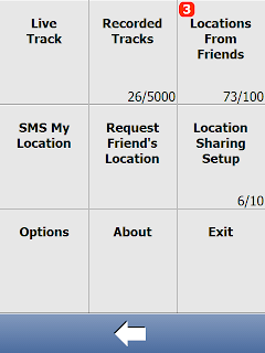
Sample Screens
Here are some more sample screens and their descriptions.
Main screen to show location, distance, travel time, speed, travel direction and GPS status
Live track
System menu
Location sharing security setup
Send a SMS to get remote phone's location information.
After receiving SMS for location information, display it in Google Maps. Kath is likely indoor and inside Guanyun Garden.
GPS track displayed in Google Maps.
Like it? Share with your friends!
If you got an error while installing Themes, Software or Games, please, read FAQ.
Supported operating systems:
Windows Mobile 6 Classic, Windows Mobile 6 Professional, Windows Mobile 6.1 Classic, Windows Mobile 6.1 Professional, Windows Mobile 6.5 Professional
Similar Software:
TravelCompasses TravelCompasses - TravelCompasses uses the GPS on your PocketPC to find a "Home" position. Then the program displays a compass that rotates to your current GPS. The program also displays your current compass degrees.
This program requires that you have both the 'BeanDLL.dll' file ** and ** the runtime files for Visual Basic on your PocketPC computer
TwitsnapsMaps TwitsnapsMaps uses the GPS on your PocketPC to find your current latitude/longitude/speed and altitude and allows you to upload your position via map to Twitter.com. You can customize the maps zoom, and type via the 'Options' in the toolbar. The maps service is provided by Google.com. The map/Twitter storage is from TwitSnaps
NoteGPSer NoteGPSer - NoteGPSer allows you to make drawing/voice notes and attaches a GPS tag to the end of the file. You can also view the notes via GPS distance from your current GPS using "The Vincenty inverse formula for ellipsoids." (accuracy to within 0.5mm, or 0.000015")
This program requires that you have both the 'BeanDLL
TravelEncyclopediaer TravelEncyclopediaer uses the GPS on your PocketPC to find your current latitude/ longitude/ speed/ altitude and looks up the Wikipedia.org GPS listings and displays them. Tap the button to start the GPS and when you get the lock tap the button again to view the Wikipedia.org listings for the area. This service is provided by Geonames
Terracrosser Terracrosser is a free GPS navigation software for Windows Mobile Pocket PC.
· Terracrosser works in Map and Photo modes
· Terracrosser uses zoomable maps
· Terracrosser is completely compatible with Google Maps service. With included Mapper module you can download maps from the Internet
PictureGPSeds PictureGPSeds - PictureGPSeds is a full-featured picture/video GPS tagger. When a new picture/video is detected in the camera folder the current GPS is appended to the end of the file. You can browse the files via GPS and map them. You can also send them via email.
This program requires that you have both the 'BeanDLL
Satsports Log Satsports Log is your general sport app. Ideal for running, cycling, mountain biking, hiking and walking. It also has some fun visual features such as maps and graphs of your elevation, speed and pace. Real time Statistics: Satsports-log has all the stats you could wish
RestaurantGoogler RestaurantGoogler uses the GPS on your PocketPC to find the top 50 closest local Restaurants sorted via GPS distance. Tap the button to start the GPS and when you get a lock tap on it to view the list of local Restaurants. You can also dial the Restaurant. The GPS maps and business search service is provided by Google
TaxiGPSeds TaxiGPSeds - TaxiGPSeds can be used by a taxi driver that gets a GPS pickup. The program gets the current GPS and allows entry of the pickup GPS. Then you can view the distance and download the route map from the Google.com map service.
This program requires that you have both the 'BeanDLL.dll' file ** and ** the runtime files for Visual Basic on your PocketPC computer
FON Access Points for Jamaica FON Access Points for Jamaica - FON offers you a new Points of Interest service (POIs). This allows you to download FONspots directly to your navigation device.
What does that mean? You can download a Points of Interest file directly to your navigation device
Other Software by developer «Ellpa»:
not found
Comments on GpsU:
Comments not found
If you noted an error or download link is broken, please, report it via this page or use comments.
GpsU is compatible with your device NTT DoCoMo dynapocket T-01B