mdNavMobile is a waypoint-based GPS navigation solution for the Windows Mobile platform. It can guide you from waypoint to waypoint while keeping you informed of all relevant navigation data. All NMEA-data from a GPS is automatically logged to file so you can 'replay' a trip with variable speed.
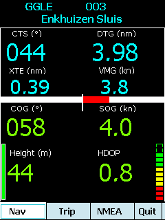
· GPS info: Latitude, Longitude, COG, SOG, Height, Satellites, HDOP and NMEA-stream
· Waypoint info: CTS, DTG, TTG, VMG, XTE
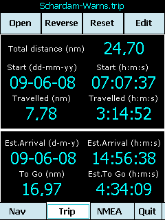
· Trip info: Total distance, Start, Travelled distance/time, DTG, TTG, ETA
· Reverse and Reset trips
· Scroll to next/previous waypoint
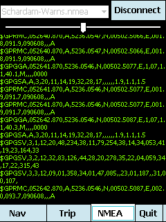
· Logs full NMEA stream from GPS to Storage Card
· Simulation using NMEA-log files with variable speed (factor 0.01-100)
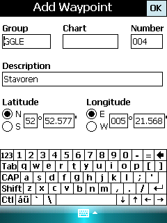
· Create/Edit Trips and Waypoints
· Show data in nm/kts/ft or km/kmh/m
· Change colors
· Trip-files also editable with notepad
· Totally free
Like it? Share with your friends!
If you got an error while installing Themes, Software or Games, please, read FAQ.
Supported operating systems:
Windows Mobile 5.0, Windows Mobile 6 Classic, Windows Mobile 6 Professional, Windows Mobile 6.1 Classic, Windows Mobile 6.1 Professional, Windows Mobile 6.5 Professional
Similar Software:
GPS Tuner Essentials Full Version with BENELUX Basic Map Content GPS Tuner Essentials Full Version with BENELUX Basic Map Content is designed specifically for off-road use: its large buttons, selectable tool window size, multiple Compass views and the built-in Tele Atlas map makes it extremely user-friendly and reliable
TravelEncyclopediaer TravelEncyclopediaer uses the GPS on your PocketPC to find your current latitude/ longitude/ speed/ altitude and looks up the Wikipedia.org GPS listings and displays them. Tap the button to start the GPS and when you get the lock tap the button again to view the Wikipedia.org listings for the area. This service is provided by Geonames
MapFingerer MapFingerer - MapFingerer allows you use the GPS on your device or custom GPS values to download maps from Google.com and keeps them in a finger friendly database. You can make multiple pages for the maps. Tap on the map to button to view it.
This program requires that you have both the 'BeanDLL
Leaf Locate Leaf Locate - Navigation in the palm of your hand
OSMtracker OSMtracker is an application for Windows Mobile Pocket PCs and SmartPhones. The main features are track logging (gpx) and quick (voice) waypoint annotations when driving a car or on a bicycle. It also has a smooth scrolling map with heading indicator
BoatOdometers BoatOdometers - BoatOdometers uses the GPS on your PocketPC to measure your boat's speed and displays it in real time in Knots/hr, KM/hr and Miles/hr. The program also displays your latitude and longitude.
This program requires that you have both the 'BeanDLL.dll' file ** and ** the runtime files for Visual Basic on your PocketPC computer
FON Access Points for Jersey FON Access Points for Jersey - FON offers you a new Points of Interest service (POIs). This allows you to download FONspots directly to your navigation device.
What does that mean? You can download a Points of Interest file directly to your navigation device
Mobbyway (Windows Mobile) Mobbyway - Based on both internet mobile technologies and GPS, Mobbyway allows you to know easily, at any time, your relatives’ exact position on a map if they have accepted it and if they are connected to the network.
Mobbyway is also a help on the road network with a local alert system of a dangerous zone which is carried out with the network of members
Terracrosser Terracrosser is a free GPS navigation software for Windows Mobile Pocket PC.
· Terracrosser works in Map and Photo modes
· Terracrosser uses zoomable maps
· Terracrosser is completely compatible with Google Maps service. With included Mapper module you can download maps from the Internet
TwitterGPSerer TwitterGPSerer allows you to oAuth update and view Twitter contacts via GPS. You can use the GPS to find your current location and send a tweet and also track your friends via Twitter. The map service is provided by Google.com. The tweet service is provided by Twitter
Other Software by developer «Maurits Dijkens»:
not found
Comments on mdNavMobile:
Comments not found
If you noted an error or download link is broken, please, report it via this page or use comments.
mdNavMobile is compatible with your device O2 XDA Comet


")

