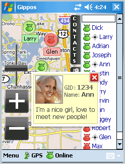
Gippos is an application for mobile devices allowing the user to locate his or her position on the map, share the location with friends and see other users on the same map. Users can also exchange instant messages with their friends.
You will need a GPS receiver for locating yourself on the map and the Internet connection for locating other users and exchanging messages with them.
Currently Gippos supports GoogleMaps and Microsoft maps. The maps are cached and the cached sections can be viewed offline.
You can hide your location if you don''t want other users to see you on the map. You can also see a Gippos user on the map at www.gippos.com if the user didn''t hide his location.
Currently Gippos is compatible with Windows Mobile 5.0/6.0, soon Gippos for iPhone and for PC (win32) will be released.
If you got an error while installing Themes, Software or Games, please, read FAQ.
Supported operating systems:
Windows Mobile 5.0, Windows Mobile 6 Classic, Windows Mobile 6 Professional, Windows Mobile 6.1 Classic, Windows Mobile 6.1 Professional, Windows Mobile 6.5 Professional
Similar Software:
PocketReperion PocketReperion is Windows Mobile Software that brings you instant live GPS Tracking in Google Earth, Virtual Earth and Google Maps.
The client can upload your GPS positions to our server every 10 seconds or more. You can configure the minimal distance that you should move before an update is sent
SirfGPSTweaker SirfGPSTweaker - application for displaying output from NMEA or SIRFBINARY based GPS device.
It has autodetection of data format (so it works both in NMEA or SIRF with on the fly detection). It can display statistics and data panel for cockpit use. Cockpit mode includes history graphs for speed and altitude
GPS Clock GPS Clock - This application is part of the author's "30 Days of .NET" initiative to develop 30 mobile applications in 30 days. The source code of the application is included in order to help programmers new to Windows Mobile development write applications in .NET.
I couldn't resist creating another GPS related mobile application
Satski Satski - The #1 ski/snowboard app. Real time ski navigation on 3D trail/piste maps. Imagine seeing your live GPS position, tracking & stats (speed, dist, alt). Use buddy tracking, get resort info, live weather, SOS
FON Access Points for Ireland FON Access Points for Ireland - FON offers you a new Points of Interest service (POIs). This allows you to download FONspots directly to your navigation device.
What does that mean? You can download a Points of Interest file directly to your navigation device
mdNavMobile mdNavMobile is a waypoint-based GPS navigation solution for the Windows Mobile platform. It can guide you from waypoint to waypoint while keeping you informed of all relevant navigation data. All NMEA-data from a GPS is automatically logged to file so you can 'replay' a trip with variable speed
FileGPSes FileGPSes - FileGPSes allows you to browse and execute the GPS tagged files and view them sorted in distance from your current GPS. You can also view and download the files placed on a Google.com map. This program uses "The Vincenty inverse formula for ellipsoids." (accuracy to within 0.5mm, or 0
Woodpecker GeoScout GeoScout is designed to be the only software you need to go geocaching. You can download/import, view and manage all caches of interest. With a connection to a suitable GPS, GeoScout can also guide you to the cache waypoint(s).
GeoScout requires individual gpx files for each cache, however don''t worry if you don''t have these
FON Access Points for Colombia FON Access Points for Colombia - FON offers you a new Points of Interest service (POIs). This allows you to download FONspots directly to your navigation device.
What does that mean? You can download a Points of Interest file directly to your navigation device
MapTexterer MapTexterer - MapTexterer allows you to create text based GPS maps. When you get a GPS lock then you can create a new map and enter text for the area. When you save the text the map is downloaded and the text and GPS is appended to the end of the map with current GPS.
This program requires that you have both the 'BeanDLL
Other Software by developer «Versane LLC»:
not found
Comments on Gippos:
Comments not found
If you noted an error or download link is broken, please, report it via this page or use comments.