mdNavMobile is a waypoint-based GPS navigation solution for the Windows Mobile platform. It can guide you from waypoint to waypoint while keeping you informed of all relevant navigation data. All NMEA-data from a GPS is automatically logged to file so you can 'replay' a trip with variable speed.
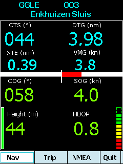
· GPS info: Latitude, Longitude, COG, SOG, Height, Satellites, HDOP and NMEA-stream
· Waypoint info: CTS, DTG, TTG, VMG, XTE
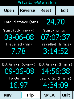
· Trip info: Total distance, Start, Travelled distance/time, DTG, TTG, ETA
· Reverse and Reset trips
· Scroll to next/previous waypoint
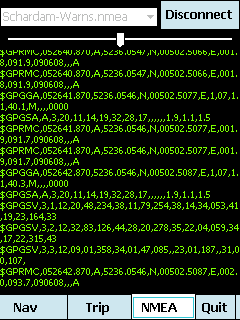
· Logs full NMEA stream from GPS to Storage Card
· Simulation using NMEA-log files with variable speed (factor 0.01-100)
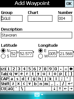
· Create/Edit Trips and Waypoints
· Show data in nm/kts/ft or km/kmh/m
· Change colors
· Trip-files also editable with notepad
· Totally free
Like it? Share with your friends!
If you got an error while installing Themes, Software or Games, please, read FAQ.
Supported operating systems:
Windows Mobile 5.0, Windows Mobile 6 Classic, Windows Mobile 6 Professional, Windows Mobile 6.1 Classic, Windows Mobile 6.1 Professional, Windows Mobile 6.5 Professional
Similar Software:
SciLors Fahrplanauskunft SciLor's Fahrplanauskunft is a tool for searching timetables for bus and trains in germany over VRR.de and Deutsche Bahn.
You can save those plans and take a look on them offline
DAN DAN - DAN is a sample application for the Pocket PC that is designed to illustrate how commercial Pocket APL applications may be marketed.
Dyalog APL Navigator (DAN) suggests the quickest routes through the subway systems of various cities, namely: Copenhagen, London, Madrid, Milan, Paris, St. Petersburg, Tyne and Wear
SMSAirline SMSAirline allows you to enter an airline flight number e.g. 'AC 123' and checks the status on the FlightStats.com website and reports it via SMS. Enter the flight code and tap the button to check the status. This service is provided by Google
Visitor Guide Metro+ Amsterdam Visitor Guide Metro+ Amsterdam is a route planner for the Metro, Tram and local National Rail network of Amsterdam. It consists of two maps:
The Metro and local National Rail network of Amsterdam
The Tram of Amsterdam.
Other Cities available
PocketMiles for WM Professional v1.3 PocketMiles for WM Professional v1.3 - PocketMiles v1.2 is software for your Windows Mobile 5 Pocket PC/Windows Mobile 6 Professional & Classic device that records and reports travel expenses and trip information
Sqij - Traffic Sqij - Traffic - This applet receives traffic incident alerts from zones that you can personalize. You can setup monitoring of a whole city, or individual ZIP codes, with filtering on different severity levels. You can optionally press a key to retrieve a small, mobile-optimized map of the affected area
MetrO (PPC) Metro helps you find your way in the public transport systems (subway, bus, trams, ...) in more than 4000 cities around the world. FREE, FAST & ACCURATE. Simply enter you start and end stops, hit the "Go" button and the program finds the fastest route
busGuide2 busGuide2 is a Windows Mobile application to get the bus arrival timing of SBS buses at different bus stops in Singapore.
This is an upgrade to the previous busGuide application and has an improved UI. SMRT supported bus stops are now highlighted and bus numbers are color coded to differentiate SMRT and SBS busses
iPoint iPoint -
Overview iPoint is a powerful application that help you plan your trip. It comes with PC release(free) and Pocket PC release. You can plan your trip, collect information with PC release and take it with you on Pocket PC. iPoint is a location-based database using any map in image format(.jpeg, .bmp, .png, .gif)
Bus Guide Bus Guide - A comprehensive guide for public buses in Singapore. Covering both SBS and TIBS buses with route searching function. This is a lite version of Transport Guide which does not contain MRT information. Features:
Route searching and detail itinerary
Other Software by developer «Maurits Dijkens»:
not found
Comments on mdNavMobile:
Comments not found
If you noted an error or download link is broken, please, report it via this page or use comments.
mdNavMobile is compatible with your device O2 xda Exec


")


