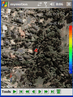
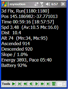
MyMotion - GPS route recording and playback with customizable spoken feedback of speed, distance and time. Uses a moving map to show progress as well as textual output. Maps can be generated from Google Earth installed on a PC using a map creation tool. Allows user to record a route then load it up as a reference for live comparison the next time it is traversed. Optional location tracking of GPS devices with GPRS or 3G, via the web and Google Earth or Google Maps.
· This software is free for personal use.
What's New in This Release:
· Performance Improvements, particularly UI responsiveness.
· User definable default file name format for track save.
· Add sensitivity enabling for menu items.
· Bug fixes: Fixed arrow direction. Fixed corruption with long (> 32 chars) file names in track files.
Like it? Share with your friends!
If you got an error while installing Themes, Software or Games, please, read FAQ.
Supported operating systems:
Windows Mobile 2003, Windows Mobile 5.0, Windows Mobile 6 Classic, Windows Mobile 6 Professional, Windows Mobile 6.1 Classic, Windows Mobile 6.1 Professional, Windows Mobile 6.5 Professional
Similar Software:
FON Access Points for Philippines FON Access Points for Philippines - FON offers you a new Points of Interest service (POIs). This allows you to download FONspots directly to your navigation device.
What does that mean? You can download a Points of Interest file directly to your navigation device
GpsPort (Pocket PC) GpsPort (Pocket PC) is a TrekBuddy companion application for WM devices. It redirects COM port to TCP socket. This way TrekBuddy can access internal GPS where Java does not support serial port access (eg. Esmertec Jbed). TrekBuddy uses localhost (127.0.0.1) connection to read the NMEA data
NoteGPSer NoteGPSer - NoteGPSer allows you to make drawing/voice notes and attaches a GPS tag to the end of the file. You can also view the notes via GPS distance from your current GPS using "The Vincenty inverse formula for ellipsoids." (accuracy to within 0.5mm, or 0.000015")
This program requires that you have both the 'BeanDLL
GPSRulerer GPSRulerer uses GPS to find two points and uses the "The Vincenty inverse formula for ellipsoids." (accuracy to within 0.5mm, or 0.000015"). Select 'Start GPS' to start the GPS and when you get a lock you can view your current GPS. Tap the button to save it and measure your distance. The map service is provided by Google
PictureGPS PictureGPS allows you to tag pictures from your PocketPC camera in real time with a GPS stamp and view the distance of each picture via your current GPS. You can use the ruler to view the distance of each picture and also view the GPS stats for each picture with a Google.com map. The map service is provided by Google
Mobile Notes "Where I've been?" feature
Record track lines, points of interest(POI).
Different colors indicate different speed route.
Record text, picture and video style POI.
Record raw gps nmea data for reference and analysis.
Attach pictures to tags of geographical information
Map Calibrator Map Calibrator - If you would like to calibrate maps on your desktop PC, use free Map Calibrator program. Map Calibrator is also useful to create map slices from a huge bitmap image file. You can convert GIF, BMP and PNG files into JPG file to use it in GPS Tuner as well
Navio Navio is the perfect companion for your GPS receiver!
Navio gives you access to all the information from your GPS receiver on your Pocket PC 2002/2003/WM5/WM6 device or Windows computer (95/98/NT4/Me/2000/XP)
NoniGPSPlot Pocket PC NoniGPSPlot allows you to locate your position in relation with other GPS points, to see the journey you have traveled.
You can find back your place at harbour after a trip on boat, the starting point of an excursion or locate your car in a huge car park, A place of which you know the location, To see the excursion you made, Speed trap alert or lots of other things..
CompeGPS Pocket Air CompeGPS allows you to carryout several functions with routes, tracks, maps and other objects, it is fully communicates with your GPS. You can load tracks, waypoints and routes from PC to GPS and vice versa very easily and quickly. MAPS. One of CompeGPS main features is the use of maps
Other Software by developer «Ian Pendlebury»:
not found
Comments on MyMotion:
Comments not found
If you noted an error or download link is broken, please, report it via this page or use comments.
MyMotion is compatible with your device O2 xda Exec


")


