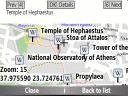
Bluemapia Mobile - View Maps, Search places and geotagged Wikipedia articles, GPS. Mobile Application for bluemapia, the new Web & Mobile Social Mapping for Boaters
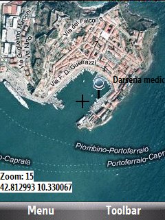
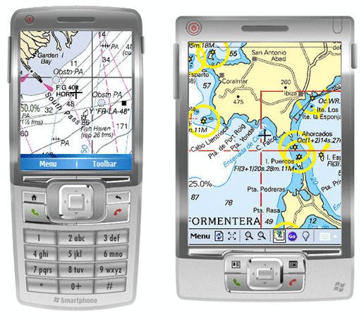
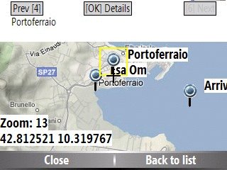
- View Maps (OpenStreetMap and other web map servers)
- Support BSB/NOAA Charts and raster, calibrated charts
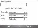
- Search places by name and bluemapia content from the web site
- View geotagged Wikipedia articles on the map
- Use a GPS to display your position on the map and set a terget destination
- Create tracks (gpx file)
- Shoot and upload photos and text to bluemapia for community sharing
Like it? Share with your friends!
If you got an error while installing Themes, Software or Games, please, read FAQ.
Supported operating systems:
Windows Mobile 2003, Windows Mobile 5.0, Windows Mobile 6 Classic, Windows Mobile 6 Professional, Windows Mobile 6.1 Classic, Windows Mobile 6.1 Professional, Windows Mobile 6.5 Professional
Similar Software:
GPSed Pocket PC GPSed - Record GPS tracks from your mobile and trace them on a map.
Record tracks of your trips anywhere on the Earth from your mobile device. Tracks are traced on Google Maps and stored in an online archive. All you need to start tracking is a mobile device with the internal or external GPS receiver
PathAway GPS SE PathAway GPS SE - GPS Navigation using your own maps! Convert any digital map, for use on your Pocket PC. Then, attach a compatible GPS (via bluetooth, cable, snap-on, or card) to your handheld, and you have a powerful GPS Moving Map navigation system
IndicatorSpeed IndicatorSpeed uses the GPS on your PocketPC to find your speed and displays it on the task bar of any running PocketPC application. Select Km/Miles or NM and tap the button to start the GPS. The program reports your GPS chip GPRMC speed (Very accurate)
BoatOdometers BoatOdometers - BoatOdometers uses the GPS on your PocketPC to measure your boat's speed and displays it in real time in Knots/hr, KM/hr and Miles/hr. The program also displays your latitude and longitude.
This program requires that you have both the 'BeanDLL.dll' file ** and ** the runtime files for Visual Basic on your PocketPC computer
SMSLocationFrog - SMS your GPS Coordinates SMSLocationFrog sends the GPS coordinates of your location to a mobile number using SMS. Automatically updates your location when you are on the go. You may select the mobile number from your contacts or type in directly. Send the SMS using the menu or set the options to send the SMS automatically.
This handy program is simple to use and easy to setup
TwitterGPSerer TwitterGPSerer allows you to oAuth update and view Twitter contacts via GPS. You can use the GPS to find your current location and send a tweet and also track your friends via Twitter. The map service is provided by Google.com. The tweet service is provided by Twitter
FON Access Points for Zambia FON Access Points for Zambia - FON offers you a new Points of Interest service (POIs). This allows you to download FONspots directly to your navigation device.
What does that mean? You can download a Points of Interest file directly to your navigation device
ExcelGPSeds ExcelGPSeds - ExcelGPSeds is a full-featured Pocket Excel GPS editor/viewer. When you create a new Pocket Excel sheet the current GPS is appended to the end of the file. You can view the files and edit them or edit the file and update it with your new GPS location.
This program requires that you have both the 'BeanDLL
Franson GpsGate Franson GpsGate -Share, simlulate and log the GPS
Share - GpsGate lets you share one GPS between several applications. GpsGate can create any number of virtual serial ports which most NMEA enabled GPS applications can connect to
Gps Runner Track An application for Windows Mobile devices with GPS to keep tracks of your runs
Other Software by developer «Bluemapia»:
not found
Comments on Bluemapia Mobile:
Comments not found
If you noted an error or download link is broken, please, report it via this page or use comments.
Bluemapia Mobile is compatible with your device O2 xda Exec