iPoint -
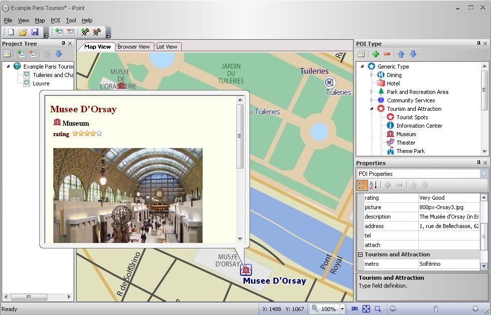
Overview iPoint is a powerful application that help you plan your trip. It comes with PC release(free) and Pocket PC release. You can plan your trip, collect information with PC release and take it with you on Pocket PC. iPoint is a location-based database using any map in image format(.jpeg, .bmp, .png, .gif). Sharing data with others is as easy as a click of a button. iPoint is a fully functional database, where users can define their own categories as well as the attributes of each specific category. Yet iPoint is not simply a database. You can load in multiple maps and mark POI (points of interest) on the maps. Each individual point can have its own specified attributes, such as telephone numbers, addresses, descriptions, attached images, and attached files. In addition to plotting out favorite restaurants and planning your next trip, you can also make a simple neighborhood map, a hiking or cycling path, or even your walking routes. Using any map of any location, you can plot any plan.
Version 1.2 New Features:
Global map view.
Search POI supported.
Faster map viewing.
Version 1.1 New Features:
Map Calibration
Navigation window support in Pocket PC
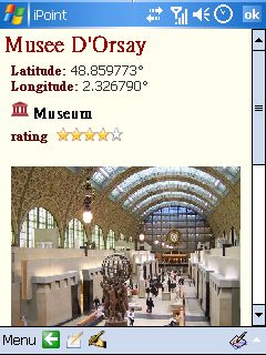
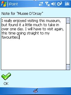
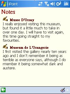
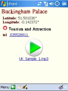
Take notes on each Point-Of-Interest.
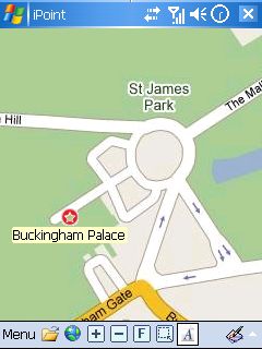
Edit Information in Pocket PC
Features
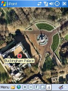
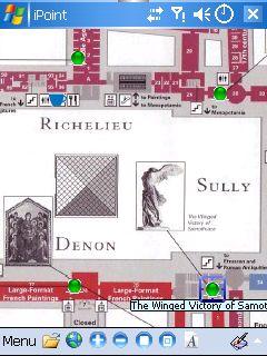
Support different image format (jpg, bmp, png, gif, etc) as map. It can be screenshot, scanned file, or digital photo.
Support large map files. No file size limitation and fast map browsing on both PC and Pocket PC.
Multiple maps insertion.
Multilingual data input.
User defined points of interest icons.
Easy to plan your next trip, and to collect the information into your map.
Support multiple maps.
After map calibration, show the same POI on different map view.
Easily browse map and tour spot information
Zoom in, zoom out, zoom all, and zoom area (draw a rectangle to zoom in)
Show or hide point of interest name
Easily switch between maps
Navigation Window on the left-top corner
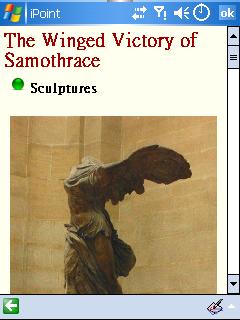
Take notes on each Point-Of-Interest
Browse the note summary.
Easiest way to keep your travel log on your trip.
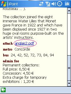
Click on attached file will open the file.
Attached file can be of any types. It can be pdf file, map3, Word Doc file, Excel file, etc.
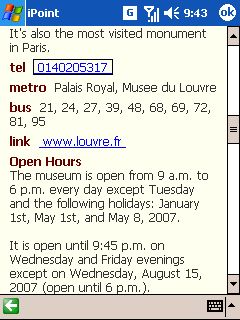
Click on telephone field will make phone call.
Click on attached mp3 file will invoke Media Player.
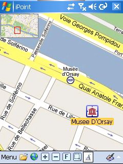
Use the museum floor plan as a map. Collect the information of art you are interested in. You can prepare your own tour guide.
Like it? Share with your friends!
If you got an error while installing Themes, Software or Games, please, read FAQ.
Supported operating systems:
Windows Mobile 2003, Windows Mobile 5.0
Similar Software:
SG Rush Hour SG Rush Hour - This application is intended for motorists in Singapore, to view Traffic Cams.
· Allows multiple cameras to be selected and displayed. Up to 12 cameras at once
· Save up to 4 Favorite routes, with each route storing up to 12 cameras
· Small program size and quick startup
MetrO (PPC) MetrO (PPC) helps you find your way in the public transport systems (subway, bus, trams, ...) in more than 4000 cities around the world. FREE, FAST & ACCURATE. Simply enter you start and end stops, hit the "Go" button and the program finds the fastest route
Cabines Air France Cabines Air France - With help from Air France, our friends at PalmAttitude offer a utility making a traveler's trip much easier from the time of registration. With Cabines Air France, you have access to all cabin plans on the Air France Fleet
Visitor Guide Tube + London The ultimate animated Route Planner for the Public Transport System of London. Covers the Tube, Tram, DLR, River and Silverlink Services of London. Other cities available
Visitor Guide Subway New York (Weekend) Visitor Guide Subway New York is an application that helps you find your way in cities, public transport systems, museums, zoo's, exhibitions and many other places. Visitor Guide combines the functionality of a route planner and an information guide
Visitor Guide Subway New York is a great, easy to use, animated route planner for the complex subway system of New York
Visitor Guide City Centre London Visitor Guide City Centre London is an application that helps you find your way in cities, public transport systems, museums, zoo's, exhibitions and many other places. Visitor Guide combines the functionality of a route planner and a city guide
City Centre London is a route planner and Tourist Guide for the City Centre of London
Earthcomber USA Earthcomber USA is a free personal navigation and "favorites finder" suite for desktop, notebook and Pocket PC. Get software, mobile mapping, and community networking in one unique package. Earthcomber runs on devices or from your SD card, and comes with rich digital street maps of the entire USA. Earthcomber includes 1
RideSchedulesSeattle RideSchedulesSeattle - The RideSchedulesSeattle application is a full-featured schedule feed reader for Metro Transit and other agencies serving the Seattle area. Offline support, alarms, favorite stops, countdowns, parking meter, vehicle finder, automatic schedule updates, and convenient access to info and online services
Fizz Flight Status Fizz Flight Status is used in conjunction with Fizz Traveller 3 to help you plan all your travel. Fizz Flight Status allows you to track your flights in real time, check gate and terminal information and see any delays quickly and with all the information you need
Fizz Flight Status is a subscription product
Other Software by developer «iTravel Tech Co., LTD.»:
iPoint Louvre Guide iPoint Louvre Guide - Overview If you only have one day or half a day to visit the Louvre, this is the guide you need. Study the map and decide what you want to see. You can also browse it on PC and make the plan in advance. Enjoy your day. - Include floor plans of 2nd floor, 1st floor, ground floor, and lower ground floor
Travel in Spain - Eating Cheat Sheet 2 Travel in Spain - Eating Cheat Sheet 2 - One of the great treasures of travel is the dining experience. Eating Cheat Sheet - Spain 2.0 is an indispensable tool while exploring Spain. To truly understand the culture of a country one must understand the local food


")


")

")


