Symbian OS | Pocket PC | Smartphone | Android | BlackBerry | Apple iPhone OS | Java | Mobile Gaming | Linux | Palm | Win CE | Tablet  
     

Free Mobile Software, Themes, Games, Apps for PDA and Smartphones

     
Search by Device
My Device

  
Last Viewed Apps
Earthlink U.S.A. Access Numbers for HanDBase
Mobile Mouse for Android
EasyAccess
d )
Ink Theme Keyboard
Iphigenia in Tauris for MobiPocket Reader
Sleep Interpreter for SL4A
The Purchase Price for MobiPocket Reader
EemeeMail
The Satyricon - Volume 06: Editor's Notes for MobiPocket Reader
Search by Category
Business & Profession
Databases
Dictionary & Translator
Entertainment
Finance
Games
Healthcare & Medicine
Internet & Communications
Multimedia & Graphics
Organisation & Productivity
Programming & Development
Reading
Science & Education
System Utilities
Themes & Wallpapers & Skins
Travel & Navigation
Geocaching
GPS
Guides
Maps
Measuring & Compass
Travel Planning
Weather
Worldtime
More
Search by Platform
Android
Apple iPhone OS
iPad
iPhone
iPod Touch
BlackBerry
Java
Linux
Maemo Nokia Internet Tablet
MeeGO
Sharp Zaurus
Mobile Gaming
Nintendo DS
Playstation 3
Playstation Portable
Wii
Xbox 360
Palm OS
Symbian OS
Series 60
Series 80
Series 90
UIQ
Tablet PC
Windows CE.NET
Windows Mobile Pocket PC
Windows Mobile Smartphone


Achivx Partner
 
 
Sunset GPS Logger


Sunset GPS Logger
Version: 3.00

Platforms: Pocket PC


Categories: Travel & Navigation

Upload date: 4 Feb 10

Developer:

License: Freeware

Downloads: 4216

File Size: 740 Kb
Download Free Sunset GPS Logger 


Rating: 2.2/5 (Total votes: 13)


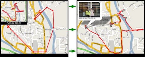
Sunset GPS Logger-allows you to capture your activities (walking, running, cycling, snowboarding, hiking trails .etc) for later visualisation on Google maps. Combined with your existing digital camera it becomes an indispensable tool to simplify the process of geo-tagging those precious photos and memories.

Installation Instructions:
1) Install the application by copying the cab file to your device via ActiveSync then running it on your device.
2) Ensure you have paired up a GPS receiver with your device and have assigned 'com7' as the outgoing devices com, for devices with a built in GPS ensure this is the GPS 'Hardware' port not programme port.
3) To start GPS logging select Menu -> Start GPS Trail.
4) To stop logging select Menu - > Stop GPS Trail.
5) You can find all your GPS logs in the following device directory 'Storage CardGPSLogs'.
6) International locale issue: If you live outside the UK to ensure GPX format compatibility please set you normal number format to the following (English: '.' For decimal and ',' as digit grouping).

Additional Notes: To GPS tag your photos: use the gpx log files in combination with Microsoft's WWMX Location Stamper or DGManager.NET Nb. For the best results ensure that BOTH your Mobile device and Digital cameras date/time settings are identical, as both rely heavily on date/time in GPS tagging your photos.


Like it? Share with your friends!

If you got an error while installing Themes, Software or Games, please, read FAQ.
 

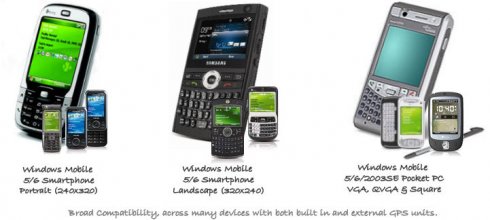
Supported operating systems: Windows Mobile 5.0, Windows Mobile 6 Classic, Windows Mobile 6 Professional, Windows Mobile 6.1 Classic, Windows Mobile 6.1 Professional, Windows Mobile 6.5 Professional
 
Similar Software:

PROGOROD FOR WINDOWS MOBILEPROGOROD FOR WINDOWS MOBILE
Auto Navigation GPS(Russia)
TravelCompassesTravelCompasses
TravelCompasses - TravelCompasses uses the GPS on your PocketPC to find a "Home" position. Then the program displays a compass that rotates to your current GPS. The program also displays your current compass degrees. This program requires that you have both the 'BeanDLL.dll' file ** and ** the runtime files for Visual Basic on your PocketPC computer
TTSGpserTTSGpser
TTSGpser - TTSGpser uses text-to-speech to tell you the current GPS coordinates. To use the app, simply run it, wait for the program to get a GPS lock, and then press the button to hear your location spoken in a female voice. The application uses Google's TTS engine
Gpx2binGpx2bin
Gpx2bin - Gpx2bin is a GPS track converter software for Windows Mobile. It can be used to convert .gpx, .mps, .plt and .nmea formats to the tracks.bin file used by Navitel Navigator to see the track as "blue line." What's New in This Release: · A problem with large files opening was fixed
BT747 MTK GPS Datalogger Device ControlBT747 MTK GPS Datalogger Device Control
BT747 MTK GPS Datalogger Device Control - i-Blue 747 / i-Blue 757 / Qstarz BT-Q1000 / i.Trek Z1 / Konet BGL-32 / Holux M-241 / ... control SW (for PalmOS, WinCe (PPC), Java platform, Windows, Linux, and MacOS). Compatible with most MTK GPS based loggers. What's New in This Release: · Added M1000C support What's New in  2.0
GPS Tuner Atlas Full Version with South America Basic Map ContentGPS Tuner Atlas Full Version with South America Basic Map Content
GPS Tuner Atlas Full Version with South America Basic Map Content is designed specifically for off-road use: its large buttons, selectable tool window size, multiple Compass views and the built-in Tele Atlas map makes it extremely user-friendly and reliable
GPSSpeedometererGPSSpeedometerer
GPSSpeedometerer uses the GPS on your PocketPC to find your speed based on the NMEA RMC sentence
VoiceGPSedVoiceGPSed
VoiceGPSed - VoiceGPSed allows you to create and listen to voice files based on your GPS. When you create a new voice file the GPS location is appended to the end of the file. You can explore the wave files via distance of your current GPS. This program requires that you have both the 'BeanDLL
VITO Navigator IIVITO Navigator II
VITO Navigator II-GPS navigation tool for geocaching, hiking and touring to be used without area maps. is our next navigation product, that inherits all advantages of popular VITO Navigator and includes many new features. Elaborated functionality combined with easy-to -use interface gives you unique GPS tool, working fine with the most of GPS receivers
TrekBuddyTrekBuddy
Trekbuddy is a J2ME application to be used with a GPS receiver. It is designed to work with every Java-enabled device. It features capabilities such as: * GPS tracking and simple navigation * bitmap maps (without zoom, you can store bitmap maps with different resolution instead)
 

Comments on Sunset GPS Logger:

Comments not found

Name:


Comment:


Enter text from image below:

Turn on images!


If you noted an error or download link is broken, please, report it via this page or use comments.
 

Sunset GPS Logger is compatible with your device O2 xda Exec
 
 
© Pantich 2009 - 2025 All rights reserved.