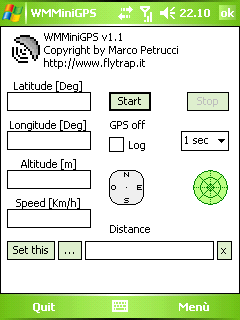
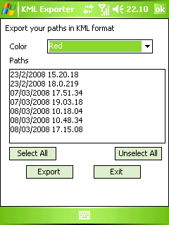
WMMiniGPSis a Windows Mobile 5/6 software which gets your GPS data in a really simple gui, showing you latitude, longitude, altitude and speed. It can log all to file and it can export your paths to Google Earth's kml and gpx format.
There's a compass, which shows your direction and you can set latitude and longitude of a point and the program will show you the way to reach it with a radar, telling you how many meters / kilometers there are to cover.
What's New in This Release:
· fixed export dialog box problem
Like it? Share with your friends!
If you got an error while installing Themes, Software or Games, please, read FAQ.
Supported operating systems:
Windows Mobile 5.0, Windows Mobile 6 Classic, Windows Mobile 6 Professional, Windows Mobile 6.1 Classic
Similar Software:
SportsGPSer SportsGPSer - SportsGPSer can be used in a sports game to track the GPS of the players in real time via FTP server. Every second the program re-FTP's the players position to the FTP server.
This program requires that you have both the 'BeanDLL.dll' file ** and ** the runtime files for Visual Basic on your PocketPC computer
LocationSMS LocateSMS permit to include your GPS-coordinates into a SMS
FON Access Points for Costa Rica FON Access Points for Costa Rica - FON offers you a new Points of Interest service (POIs). This allows you to download FONspots directly to your navigation device.
What does that mean? You can download a Points of Interest file directly to your navigation device
FON Access Points for Jersey FON Access Points for Jersey - FON offers you a new Points of Interest service (POIs). This allows you to download FONspots directly to your navigation device.
What does that mean? You can download a Points of Interest file directly to your navigation device
Satski Satski - The #1 ski/snowboard app. Real time ski navigation on 3D trail/piste maps. Imagine seeing your live GPS position, tracking & stats (speed, dist, alt). Use buddy tracking, get resort info, live weather, SOS
Where is "Where is..." is a new GPS program for Windows Mobile 5/6 completely writen in .NET. It give you a free perception of distance and direction from your destination without any connection with internet or a expansive program of navigation
Route Tracker Route Tracker - With Route Tracker you can create routes and add several route points containing text and/or images from your current position. If GPS is available it will take the current longitude, latitude and altitude. Without a GPS module information of the current cell id and the location area code are saved
e-Mobile GPS FindMe (PPC) Turn your phone into a working compass! Track your own route, or locate people you care, trace your kids whereabouts, use like a employee/vehicle tracker or even locate your lost phone
TextGPSs TextGPSs - TextGPSs can be used to make text notes with a GPS tag as the text file name and view the distance in meters of each text file in distance order via GPS. You can store your files on the storage card. You can also view the text entries with Google maps.
This program requires that you have both the 'BeanDLL
BT747 MTK GPS Datalogger Device Control BT747 MTK GPS Datalogger Device Control - i-Blue 747 / i-Blue 757 / Qstarz BT-Q1000 / i.Trek Z1 / Konet BGL-32 / Holux M-241 / ... control SW (for PalmOS, WinCe (PPC), Java platform, Windows, Linux, and MacOS). Compatible with most MTK GPS based loggers
Other Software by developer «Marco Petrucci»:
not found
Comments on WMMiniGPS:
Comments not found
If you noted an error or download link is broken, please, report it via this page or use comments.
WMMiniGPS is compatible with your device O2 xda Exec


")

