gOmniAgent - gOmniAgent provides a real-time location tracking of mobile devices. It runs silently in the background with no user interface, and helps monitoring minors and your beloved ones from the gOmniTracker mobile applications or from gOmniTracker site. It keeps track of out-of-coverage locations until the device is connected back to the server. It locates your stolen, lost, or misplaced device (as long as the battery last).
In order to make your application function, please follow these steps carefully.
1. Download Microsoft .Net CF 3.5 from gOmniTracker site and install on the device.
2. Download SQL Server Compact 3.5 Core, from the same link above. Make sure both apps are shown in Settings-System-Remove Programs.
3. Register at gOmniTracker for a new account, an email will sent to you as a confirmation with your account information.
4. Download and install the gOmniAgent, and the start it.
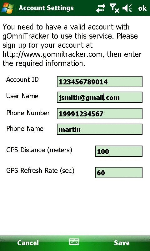
5. From the Settings screen, enter the required information as described in the email.
6. To activate your device, click on the Save button.
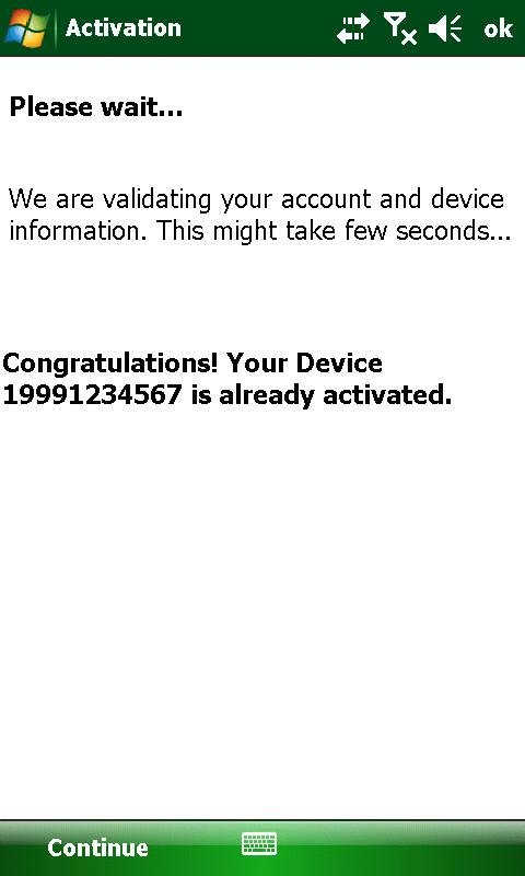
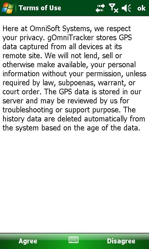
7. After the system confirmed your activation, click on continue, and agreed on the Terms of Use
8. To close the screen, just click on the X at the top right corner. This will keep the application running in the background.
Send location updates based on device settings; refresh rate, and distance between locations.
Using covert agent mode. runs silently in the background, auto-starting when phone is powered-up, and its application has no icon.
Keep track of out-of-coverage locations until the device is connected back to the server.
Locate your stolen, lost, misplaced device (as long your battery last).
Like it? Share with your friends!
If you got an error while installing Themes, Software or Games, please, read FAQ.
Supported operating systems:
Pocket PC 2002, Windows Mobile 2003, Windows Mobile 5.0, Windows Mobile 6 Classic, Windows Mobile 6 Professional, Windows Mobile 6.1 Classic, Windows Mobile 6.1 Professional, Windows Mobile 6.5 Professional
Similar Software:
MapFolderer MapFolderer uses GPS to find your current location and downloads a JPEG map of the area with a custom name. The maps are tagged with the GPS lat/lng on each JPEG file. You can also view the maps on the built in map viewer. The maps service is provided by Google
TravelGoogling TravelGoogling allows you to use the GPS on your PocketPC to find 5,451 local stores and services in sorted via distance. Tap the button to start the GPS and when you get the lock tap the button to view the business directory. Tap on a business category to view local business listings. The GPS street information is from GeoNames
GPS Diagnostics 1.0 GPS Diagnostics 1.0 - These are the problems which users typically face when they're trying to get their GPS device to work:
1. Users' Windows Mobile 5.0+ devices frequently have incorrect GPS Intermediate Driver settings.
2. Users are unaware that Bluetooth is turned off, or do not know how to configure a virtual serial port for their GPS device.
Built using GPS
FON Access Points for France FON Access Points for France - FON offers you a new Points of Interest service (POIs). This allows you to download FONspots directly to your navigation device.
What does that mean? You can download a Points of Interest file directly to your navigation device
Traffic Vizzion (12 month subscription) IMPORTANT: Do not operate this product while driving; park the vehicle first. It is your sole responsibility to place, secure and use your mobile device in a manner that ensures safe driving
TrackyPro (online GoogleMaps with GPS) TrackyPro - If you have taken your auto navigation system into the woods you probably realized that it becomes more of a paper weight than a navigation device. Without roads most cannot function. That is why you may need off-road navigation software
FON Access Points for Thailand FON Access Points for Thailand - FON offers you a new Points of Interest service (POIs). This allows you to download FONspots directly to your navigation device.
What does that mean? You can download a Points of Interest file directly to your navigation device
OS GPS Convertor OS GPS Convertor converts positions between WGS84 latitude & longitude and Ordnance Survey (OS) British & Irish or Universal Transverse Mercator (UTM) worldwide grid references. It displays positions in multiple formats.
It can be used with:
* TomTom Navigator - to create a Point of Interest (POI) or Itinerary file ... then show on map, navigate to, etc
FON Access Points for Malaysia FON Access Points for Malaysia - FON offers you a new Points of Interest service (POIs). This allows you to download FONspots directly to your navigation device.
What does that mean? You can download a Points of Interest file directly to your navigation device
TerraTrack Recorder 7 Route guidance in 3D view, makes navigation processes very simple and intuitive
Other Software by developer «OmniSoft Systems, Inc.»:
gOmniTracker Wonder where was your teenager spending time last night? or when did they leave school, home, or tennis-practice? Or maybe it's granny you're concerned about whether she got back home from the park yet
gOmniTracker (iPhone/iPad) gOmniTracker (iPhone/iPad) - Wonder where was your teenager spending time last night? or when did they leave school, home, or tennis-practice? Or maybe it's granny you're concerned about whether she got back home from the park yet? gOmniTracker can answer these questions, and more, right from your your mobile phone or from your desktop
gOmniAgent GOmniAgent runs silently in the background with no user interface and has no application icon. It helps in monitoring minors and your beloved ones from the gOmniTracker mobile application or from gOmniTracker site


")
")


