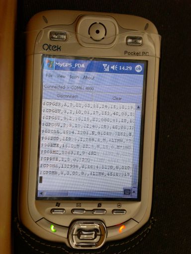
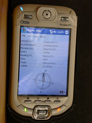
MyGPS_PDA - MyGPS_PDA is a light MyGPS version for PocketPC systems. It reads the NMEA sentences coming from a GPS antenna connected to the PocketPC and shows your position on a MyGPS calibrated map. The program can also store on a file the track log together with specific waypoints created by the user.
Like it? Share with your friends!
If you got an error while installing Themes, Software or Games, please, read FAQ.
Supported operating systems:
Windows Mobile 2003, Windows Mobile 5.0, Windows Mobile 6 Classic, Windows Mobile 6 Professional, Windows Mobile 6.1 Classic, Windows Mobile 6.1 Professional, Windows Mobile 6.5 Professional
Similar Software:
amAze (Motorola) AmAze is a first of its kind free navigation and local search service. It is free to download and use and it contains wide coverage of maps including aerial photo in Europe, North America, Australia and parts of Asia and Africa
GPSMaperer GPSMaperer is a full featured map downloader. You can enter the lat/long coordinates or use your current GPS to download a map. You can download in GIF, PNG or JPEG format. The program has several options to customize the map. The map service is provided by Google
FON Access Points for Croatia FON Access Points for Croatia - FON offers you a new Points of Interest service (POIs). This allows you to download FONspots directly to your navigation device.
What does that mean? You can download a Points of Interest file directly to your navigation device
MyGPS PDA MyGPS_PDA - a light version of MyGPS software for Pocket PC systems. It reads the NMEA sentences coming from a GPS device connected to the Pocket PC and shows your position on a calibrated map. A calibrated map can be generated using MyGPS for PC and starting from any raster image file (.bmp, .jpg, .gif). MyGPS_PDA requires the Ewe VM installed on the Pocket PC
CompeGPS Pocket Air CompeGPS allows you to carryout several functions with routes, tracks, maps and other objects, it is fully communicates with your GPS. You can load tracks, waypoints and routes from PC to GPS and vice versa very easily and quickly. MAPS. One of CompeGPS main features is the use of maps
PocketGPS Map PocketGPS Map-The program views calibrated bitmap maps (moving maps) on Pocket PC / WinCE platform.
Additionaly it supports using GPS device to retrieve user position and show it (with other marks) in map - making it very handy for geocaching
GPS.PI This program exchanges geographical position points by SMS or Email (GPRS, Bt, Wifi) services of cellular phone network.
This version works with any Pocket PC Phone Edition devices.
MS Smartphone version is available too
Mobile Speedometer Mobile Speedometer - This application is part of the author's "30 Days of .NET" initiative to develop 30 mobile applications in 30 days. The source code of the application is included in order to help programmers new to Windows Mobile development write applications in .NET
CityGoogler CityGoogler uses the GPS on your PocketPC to find the 50 closest local business from 2,238 type of Yellow Pages entry sorted via GPS distance and stores the results into files based on store type. Tap the button to start the GPS and when you get a lock tap on it to view the list of local businesses. The GPS maps and business search service is provided by Google
Other Software by developer «Paolo Faure Ragani, Pier Paolo Colombo»:
not found
Comments on MyGPS_PDA:
Comments not found
If you noted an error or download link is broken, please, report it via this page or use comments.
MyGPS_PDA is compatible with your device O2 xda IIs


")


