Symbian OS | Pocket PC | Smartphone | Android | BlackBerry | Apple iPhone OS | Java | Mobile Gaming | Linux | Palm | Win CE | Tablet  
     

Free Mobile Software, Themes, Games, Apps for PDA and Smartphones

     
Search by Device
My Device

  
Last Viewed Apps
AdjBrightness
Jones on Fire for Android
Dingless - Notification sounds
Quick System Info
WebSMS: smspilot.ru Connector
Neon Theme Keyboard Phone
OneToucher
Funny Towers Lite
Bugzilla Tweaks - Firefox Addon
Advanced Task Manager
Search by Category
Business & Profession
Databases
Dictionary & Translator
Entertainment
Finance
Games
Healthcare & Medicine
Internet & Communications
Multimedia & Graphics
Organisation & Productivity
Programming & Development
Reading
Science & Education
System Utilities
Themes & Wallpapers & Skins
Travel & Navigation
Geocaching
GPS
Guides
Maps
Measuring & Compass
Travel Planning
Weather
Worldtime
More
Search by Platform
Android
Apple iPhone OS
iPad
iPhone
iPod Touch
BlackBerry
Java
Linux
Maemo Nokia Internet Tablet
MeeGO
Sharp Zaurus
Mobile Gaming
Nintendo DS
Playstation 3
Playstation Portable
Wii
Xbox 360
Palm OS
Symbian OS
Series 60
Series 80
Series 90
UIQ
Tablet PC
Windows CE.NET
Windows Mobile Pocket PC
Windows Mobile Smartphone


Achivx Partner
 
 
Nav4All


Nav4All
Version: 1.0

Platforms: Pocket PC


Categories: Travel & Navigation

Upload date: 29 Dec 09

Developer:

License: Freeware

Downloads: 13703

File Size: 923 Kb
Download Free Nav4All 


Rating: 2.5/5 (Total votes: 21)


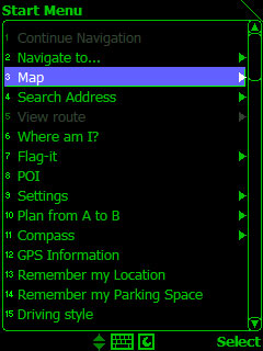
Nav4All-search and find millions of interesting places like restaurants, bars, gas stations, shops and much more. You can use the places you like as destination, save them as favorite, or share them with your friends by sms or email.

* Voice-instructions and clear arrows on your screen will guide you to your destination.
* Automatic map updates: All changes in the map information are updated automatically on our servers so you always have access to the most up-to-date information.
* Worldwide coverage: (Navteq) Abu Dhabi, Ajman, Albania, Andorra, Australia, Austria, Bahrain, Belgium, Bosnia and Herzegovina, Brazil, Bulgaria, Canada, China, Croatia, Czech Republic, Denmark, Dubai, Estonia, Fajairah, Finland, France, Germany, Gibraltar, Great Britain, Greece, Guernsey, Hong Kong, Hungary, India, Ireland, Isle of Man, Italy, Jersey, Kuwait, Latvia, Liechtenstein, Lithuania, Luxembourg, Macao, Macedonia, Malaysia, Mexico, Monaco, Northern Ireland, Norway, Oman, Poland, Portugal, Puerto Rico, Qatar, Ras Al Khaimah, Romania, Russia, San Marino, Saudi Arabia, Scotland, Serbia and Montenegro, Sharjah, Singapore, Slovakia, Slovenia, South Africa, Spain, Sweden, Switzerland, Taiwan, The Netherlands, USA, Umm Al Quwain, Vatican City, Virgin Islands (USA), and Wales.
* MyWorld: with MyWorld you can share your favorite places by sending them to one of your MyWorld maps. You can share these maps with your friends or put them on your MySpace or other website you like.
* Works on over 1000 different handsets in 56 languages: Nav4All is available in your own language on almost any mobile phone, like Blackberry, Nokia, SonyEricsson, Motorola, HTC, QTEK, HP, and many more.
* For Free! Nav4All can be used for free until 01.01.2010. (Your telecom provider may charge you for the use of Internet on your mobile phone.)
 
Like it? Share with your friends!

If you got an error while installing Themes, Software or Games, please, read FAQ.
 

Supported operating systems: Pocket PC 2002, Windows Mobile 2003, Windows Mobile 5.0, Windows Mobile 6 Classic, Windows Mobile 6 Professional
 
Similar Software:

PocketGISPocketGIS
PocketGIS is a powerful mobile Geographical Information System (GIS) for field data capture which can display and edit map geometry and attributes. PocketGIS brings real GIS functionality to highly portable handheld devices which are lightweight, convenient and have a long battery life
MapGooglerMapGoogler
MapGoogler uses the GPS on your PocketPC to find your current latitude/longitude/speed and altitude and allows you to view your position on a map from the Google.com maps service. You can customize the maps zoom, and type via the 'Options' in the toolbar. The maps service is provided by Google
Route TrackerRoute Tracker
Route Tracker - With Route Tracker you can create routes and add several route points containing text and/or images from your current position. If GPS is available it will take the current longitude, latitude and altitude. Without a GPS module information of the current cell id and the location area code are saved
CoffeeTimHortonsCoffeeTimHortons
CoffeeTimHortons uses the GPS on your PocketPC to find the 50 closest Tim Hortons shops sorted via GPS distance. Tap the button to start the GPS and when you get a lock tap on it to view the list of local Tim Hortons shops. You can also dial the store. The GPS maps and search service is provided by Google
Map CalibratorMap Calibrator
Map Calibrator - If you would like to calibrate maps on your desktop PC, use free Map Calibrator program. Map Calibrator is also useful to create map slices from a huge bitmap image file. You can convert GIF, BMP and PNG files into JPG file to use it in GPS Tuner as well
FON Access Points for AfghanistanFON Access Points for Afghanistan
FON Access Points for Afghanistan - FON offers you a new Points of Interest service (POIs). This allows you to download FONspots directly to your navigation device. What does that mean? You can download a Points of Interest file directly to your navigation device
GridHIKERGridHIKER
GridHIKER-software for handheld units. A step further than raw numeric coordinates. Recommended for paper map enthusiasts requiring determining his position. GridHIKER shows position graphically on usual Geographic grid or UTM grid which should be drown on paper map. Features: - Displaying Geographical grid for position between Lattitude -80S and 84N
SirfGPSTweakerSirfGPSTweaker
SirfGPSTweaker - application for displaying output from NMEA or SIRFBINARY based GPS device. It has autodetection of data format (so it works both in NMEA or SIRF with on the fly detection). It can display statistics and data panel for cockpit use. Cockpit mode includes history graphs for speed and altitude
FON Access Points for MoldovaFON Access Points for Moldova
FON Access Points for Moldova - FON offers you a new Points of Interest service (POIs). This allows you to download FONspots directly to your navigation device. What does that mean? You can download a Points of Interest file directly to your navigation device
ppc FindMyCarppc FindMyCar
ppc FindMyCar - Innovative software for Windows Mobile devices that uses the GPS signal to show signs that allow to reach a geographic location. Suitable for various uses (eg. find car parked in a parking area or in an unknown city, finding a person (who has sent their coordinates) in a lovely beach, in a fair, in another boat, find an area of sea fishing, etc..)
 

Comments on Nav4All:

Comments not found

Name:


Comment:


Enter text from image below:

Turn on images!


If you noted an error or download link is broken, please, report it via this page or use comments.
 

Nav4All is compatible with your device O2 xda IIs
 
 
© Pantich 2009 - 2025 All rights reserved.