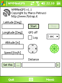
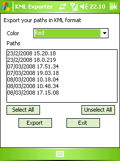
WMMiniGPSis a Windows Mobile 5/6 software which gets your GPS data in a really simple gui, showing you latitude, longitude, altitude and speed. It can log all to file and it can export your paths to Google Earth's kml and gpx format.
There's a compass, which shows your direction and you can set latitude and longitude of a point and the program will show you the way to reach it with a radar, telling you how many meters / kilometers there are to cover.
What's New in This Release:
· fixed export dialog box problem
Like it? Share with your friends!
If you got an error while installing Themes, Software or Games, please, read FAQ.
Supported operating systems:
Windows Mobile 5.0, Windows Mobile 6 Classic, Windows Mobile 6 Professional, Windows Mobile 6.1 Classic
Similar Software:
GPS Speedometer GPS Speedometer displays an attractive dash with both digital and analog display using GPS
TravelIntersections TravelIntersections uses the GPS on your PocketPC to find your current latitude/ longitude/ speed and altitude and looks up the GPS profile for it on the GeoNames.org website. Tap the button to start the GPS and when you get the lock tap the button again to view the GPS profile. This service is provided by GeoNames
FON Access Points for Jamaica FON Access Points for Jamaica - FON offers you a new Points of Interest service (POIs). This allows you to download FONspots directly to your navigation device.
What does that mean? You can download a Points of Interest file directly to your navigation device
Mobile Tracking System Mobile Tracking System is a new project from Fightersoft Multimedia that provides real time tracking and messaging services.
How does it work?
The client version of MTS is a smartphone application that can get the identification data of the current cell in use by the mobile phone
StoreGoogler StoreGoogler uses the GPS on your PocketPC to find the 50 closest local business from 2,238 type of Yellow Pages entry sorted via GPS distance. Tap the button to start the GPS and when you get a lock tap on it to view the list of local businesses. The GPS maps and business search service is provided by Google
FON Access Points for Slovenia FON Access Points for Slovenia - FON offers you a new Points of Interest service (POIs). This allows you to download FONspots directly to your navigation device.
What does that mean? You can download a Points of Interest file directly to your navigation device
myRadar myRadar is a location aware radar application that makes use of Wunderground and Accuweather US web services to show real-time, animated Radar Images of your local area regardless of where in the US you might be. This application requires myLocation services to function automatically.
The program will install to /Program Files/myRadar
GeoFence MASPware GeoFence is a GPS-based surveillance tool for Windows Mobile devices. This program loads a virtual fence (GPX/KML) and starts alerts, if the current position is out of bounds.
This program can use any kind of GPX (GPS Exchange Format) data files and can also use Google KML files. You can easily record tracks with e.g
TwitterGPSings TwitterGPSings allows you to update and view Twitter contacts via GPS. You can use the GPS to find your current location and send a tweet and also track your friends via Twitter. The map service is provided by Google.com. The tweet service is provided by Twitter
FON Access Points for Croatia FON Access Points for Croatia - FON offers you a new Points of Interest service (POIs). This allows you to download FONspots directly to your navigation device.
What does that mean? You can download a Points of Interest file directly to your navigation device
Other Software by developer «Marco Petrucci»:
not found
Comments on WMMiniGPS:
Comments not found
If you noted an error or download link is broken, please, report it via this page or use comments.
WMMiniGPS is compatible with your device O2 XDA Mantle (HTC Sedna 100)

")