Supported operating systems:
Windows Mobile 5.0, Windows Mobile 6 Classic, Windows Mobile 6 Professional, Windows Mobile 6.1 Classic, Windows Mobile 6.1 Professional
Similar Software:
TwitterGPSer TwitterGPSer uses the GPS on your PocketPC to find your current latitude/longitude/speed and allows you to update Twitter.com. Tap the button to get the GPS lock and when the program gets the lock it will create a Tweet with a Google.com map link. This service is provided by Twitter
GPS Clock GPS Clock - This application is part of the author's "30 Days of .NET" initiative to develop 30 mobile applications in 30 days. The source code of the application is included in order to help programmers new to Windows Mobile development write applications in .NET.
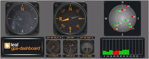
I couldn't resist creating another GPS related mobile application
SIGLOG SIGLOG - A Windows Mobile application that logs latitude, longitude, signal strength, mobile country code, mobile network code, location area code, CellID.
Written in Win32 C++ it's lean, mean, rather basic, but it does the job. It requires a phone with GPS, as it calls the Microsoft intermediate GPS driver
FamilyGPSs FamilyGPSs - FamilyGPSs can be used update your GPS location and track the GPS location of friends/family on your lists. You can view all family members on a map or view each person on a map. The map service is provided by Google.com
This program requires that you have both the 'BeanDLL.dll' file ** and ** the runtime files for Visual Basic on your PocketPC computer
GPSTwitterer GPSTwitterer allows you to oAuth update and view Twitter contacts via GPS. You can use the GPS to find your current location and send a tweet and also track your friends via Twitter. The map service is provided by Google.com. The tweet service is provided by Twitter
FON Access Points for San Marino FON Access Points for San Marino - FON offers you a new Points of Interest service (POIs). This allows you to download FONspots directly to your navigation device.
What does that mean? You can download a Points of Interest file directly to your navigation device
TravelPicturer TravelPicturer - TravelPicturer uses the GPS on your PocketPC to graphically view your GPS movement. You can adjust the slider for to view larger distances on the map. This uses "The Vincenty inverse formula for ellipsoids." (accuracy to within 0.5mm, or 0.000015")
This program requires that you have both the 'BeanDLL
VirtualGPS Virtual GPS is a free, small utility, which fully emulates GPS module and returns your location (by using cellular towers).
Accuracy of coordinates is about 200m in urban area and up to 5km in countryside. Screenshots are explaining how to use VirtualGPS with navigation software (e.g. "Google Maps")
FON Access Points for Equatorial Guinea FON Access Points for Equatorial Guinea - FON offers you a new Points of Interest service (POIs). This allows you to download FONspots directly to your navigation device.
What does that mean? You can download a Points of Interest file directly to your navigation device
TaxiGPSer TaxiGPSer - TaxiGPSer uses the GPS on your PocketPC to find your current latitude/longitude/speed and allows you to send it to a preset Taxi or shuttle service via email. Tap the button to get the GPS lock and when the program gets the lock it will send the email.
This program requires that you have both the 'BeanDLL
Comments on GPS Dashboard:
Comments not found
If you noted an error or download link is broken, please, report it via this page or use comments.
GPS Dashboard is compatible with your device O2 xda Neo