Symbian OS | Pocket PC | Smartphone | Android | BlackBerry | Apple iPhone OS | Java | Mobile Gaming | Linux | Palm | Win CE | Tablet  
     

Free Mobile Software, Themes, Games, Apps for PDA and Smartphones

     
Search by Device
My Device

  
Last Viewed Apps
Bsecure Mobile Browser for Android
TouchRemote for Android
Ghost In Camera
Linear quest
Search by Category
Business & Profession
Databases
Dictionary & Translator
Entertainment
Finance
Games
Healthcare & Medicine
Internet & Communications
Multimedia & Graphics
Organisation & Productivity
Programming & Development
Reading
Science & Education
System Utilities
Themes & Wallpapers & Skins
Travel & Navigation
Geocaching
GPS
Guides
Maps
Measuring & Compass
Travel Planning
Weather
Worldtime
More
Search by Platform
Android
Apple iPhone OS
iPad
iPhone
iPod Touch
BlackBerry
Java
Linux
Maemo Nokia Internet Tablet
MeeGO
Sharp Zaurus
Mobile Gaming
Nintendo DS
Playstation 3
Playstation Portable
Wii
Xbox 360
Palm OS
Symbian OS
Series 60
Series 80
Series 90
UIQ
Tablet PC
Windows CE.NET
Windows Mobile Pocket PC
Windows Mobile Smartphone


Achivx Partner
 
 
GPS Map Camera use GoogleMap


GPS Map Camera use GoogleMap
Version: 1.2.8

Platforms: Android


Categories: Travel & Navigation

Upload date: 19 Apr 15

Developer: Jkfantasy

License: Freeware

Downloads: 437

File Size: 2282 Kb
Download Free GPS Map Camera use GoogleMap 


Rating: 3.3/5 (Total votes: 9)


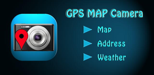
  GPS Map Camera use GoogleMap - The main feature of the 'GPS Map Camera':

When you take a piture with GPS enabled, it will paste the google map, address and weather to picture. (GPS latitue/longitude also include in the information)

Please enable your network and GPS function before using this application.

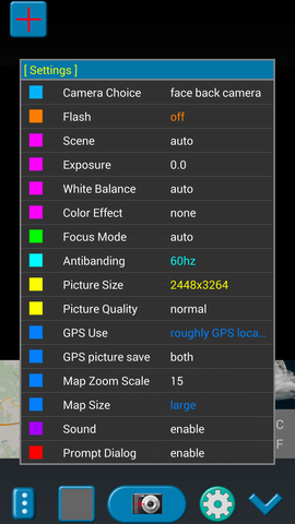
In the camera setting page, the similar functions will be grouped with the same color.

Now, Seperate the following groups if your device has support.

      1. Flash

      2. Scene/Exposure/White Balance/Color Effect/ISO.

      3. Focus Mode.

      4. Antibanding.

      5. Picture Size/Picture Quality.

      6. GPS Use/GPS Picture Save/Map Zoom Scale/Map Size.

      7. Sound.

The color of function string is white as default. If change to another function, the color will change to grouped color. It's better to recognize what you set.

The focus and zoom when preview:

Focus: use one finger to touch the screen.

Zoom: use two finger to zoom in/out.

TIPs:

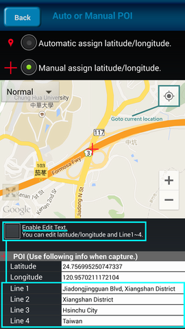
1. Don't want to get MAP: "Option Settings" --> "GPS picture save" --> choice "one (original)".

2. Don't want to save GPS position: "Option Settings" --> "GPS Use" --> choice "disable GPS".

3. Don't want to popup prompt dialog: "Option Settings" --> "Prompt Dialog" --> choice "disable". 

Others:

1. The picture saving time is more longer if the android version is below android-3.0.

2. The picture save to SD card (GpsMapCamera). Some device need a SD card.

3. In the outdoors, please set to "GPS Use" => "good GPS location"

     "GPS use" => "roughly GPS location" can be used in indoor positioning is relatively fast.

     But in some Android system, it seems have problem after using a period of time, you need to reboot to use it again or <b>upgrade you android OS</b>.

Third party resources be used (The ownership is belong to them.):

1. Google map. ( https://maps.google.com/ )

2. Yahoo weather info. (http://weather.yahoo.com/)

3. Xda weather icon (http://cpanelcloudvps.com/xda-developers-view-single-post-util-spb-mobile-shell-301/)

【PS】

 Please like us on Facebook. Give us the power of love.

 https://www.facebook.com/jkfantasy


Like it? Share with your friends!
 

Supported operating systems: Google Android 10.x, Google Android 4.0, Google Android 4.1, Google Android 4.2, Google Android 4.3, Google Android 4.4, Google Android 5.x, Google Android 6.x, Google Android 7.x, Google Android 8.x, Google Android 9.x
 
Similar Software:

GPS Coordinates ConverterGPS Coordinates Converter
GPS Coordinates Converter - With this app you can convert GPS coordinates from "degrees, minutes, decimal seconds" to "decimal degrees". What's New in This Release: · Locate your phone and show the coordinates What's New in 2
amAze (LG)amAze (LG)
AmAze is a first of its kind free navigation and local search service. It is free to download and use and it contains wide coverage of maps including aerial photo in Europe, North America, Australia and parts of Asia and Africa
My GPS Coordinates and LocationMy GPS Coordinates and Location
My GPS Coordinates and Location - A simple application with crude, but adequate, support for 40 languages. Allows you to share your position via email, text message, twitter, etc, and displays your current GPS location in both decimal format and in sexagesimal (degrees minutes seconds) format. Internet access is not required to send your location with a text message
AlpineQuest LiteAlpineQuest Lite
AlpineQuest Lite - AlpineQuest turns your Android device into an off-road GPS using offline topo maps. It is a complete solution for all outdoor activities and sports, including hiking, running, trailing, hunting, sailing, geocaching and much more
TomTom Italy for AndroidTomTom Italy for Android
TomTom Italy for Android - TomTom Italy is a turn-by-turn GPS navigator for Android devices. The app includes accurate offline maps, so you can find your way anywhere, even without an internet connection
GPS Info for AndroidGPS Info for Android
GPS Info for Android is an easy to use and functional GPS application for beginners and advanced users. All needed GPS data is bundled in one screen with perfectly designed layout, with usability in mind
CoPilot Live Premium UK + IRE (Android)CoPilot Live Premium UK + IRE (Android)
CoPilot Live Premium UK + IRE (Android) - Now there’s a better way to navigate. CoPilot Live Premium is the essential voice-guided sat navigation app to get you where you need to go, by the way that suits you best. Detailed street maps of one single European region (e.g
LocationFinderLocationFinder
LocationFinder is a LBS application. Through this application you can search any location in map. Click anywhere in map and you find the area, nearest city and country. Apart from this, user can edit any location for search and can see the location in map
GPS ToolsGPS Tools
GPS Tools - is an application for calibration of a satellite module of your smartphone. The utility uses a magnetic compass, makes changes to the route, speed and accuracy of the displayed data. As soon as the calibration is completed you can track your location with maximum accuracy
In Hand DealsIn Hand Deals
In Hand Deals - In Hand Deals is an easy to use mobile app that provides you with the most effective way to find out what deals are available in different categories or around your location; such as restaurants, fast food, coffee shops, retail stores, automotive, fuel, day spas, beauty salons, theaters and nightclubs. No need to coupon clip, check in, or score points...
 

Other Software by developer «Jkfantasy»:

Hiking Flashlight (NightFlash)Hiking Flashlight (NightFlash)
Hiking Flashlight (NightFlash) - Night Flash is a LED/Panel light communication tool and flashlight tool.  It is helpful for climber.  Have many effect and Morse code to help them do light communication. Basic : Continuous / Low / Middle / High Speed. SOS : SOS signal. Adjust : Adjust light time and dark time. Effect : Many different flash mode
Magnifier CameraMagnifier Camera
Magnifier Camera - Let your phone become a perfect magnifier. When you start camera, the APP will set the zoom to middle value. You can drag zoom seek bar to zoom in or out. When you start camera, the APP will auto detect the micro focus mode. If it exist, the APP will auto set to micro focus mode. If it doesn't exist, the APP will set to auto focus mode
Phone Usage TimePhone Usage Time
Phone Usage Time - If you too often use mobile phones, the screen light may hurt your eyes.  Please concern yourself ! Protect your eyes. How to know the total time of phone screen on?  This application can help you record your phone usage time. Each application usage time also will be recorded
GPS Photo Viewer use GoogleMapGPS Photo Viewer use GoogleMap
GPS Photo Viewer use GoogleMap - When you go to travel and take a picture, I suggest you to enable camera's GPS.  After you enable camera's GPS function, then the GPS latitude and longitude will record in the captured photo.  This application is help you to check the photo have a GPS info or not. And help to launch the Google map
Mirror CameraMirror Camera
Mirror Camera 【Function】 Sometimes you need to check your face. Or Make up. ( Though I know you are already very Handsome/Beauty. But your can ... Handsome more handsome. Beautiful more beautiful. ) Let your phone become a perfect mirror which is very convenient. (A quick check on your face if a foreign body

» show more


Comments on GPS Map Camera use GoogleMap:

Comments not found

Name:


Comment:


Enter text from image below:

Turn on images!


If you noted an error or download link is broken, please, report it via this page or use comments.
 

GPS Map Camera use GoogleMap is compatible with your device OKWU Pi TD-LTE Dual SIM
 
 
© Pantich 2009 - 2025 All rights reserved.