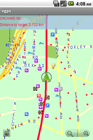
VGPS (Vietnamese GPS) for Android was designed to use city street map on your ordinary mobile phone without the need of having GPS receiver or internet connection. VGPS does not require internal or external GPS receiver. However, if you have internal GPS receiver or external bluetooth GPS receiver, VGPS can work with your GPS receiver as well. VGPS does not require internet connection so you no need to worry about connection charge.
· Offline map (totally offline application. VGPS only uses internet to validate your purchase when you activate demo version become full version. Other than that the application will never use internet)
· Map data from Garmin and OpenStreetMap
· Zoom in/Zoom out/Pan
· Search point by name,type,distance or mix type+name, type+distance
· Can touch any object on the map
· GPS real-time tracking
· Routing point to point
· Rotate map so the driving direction (heading) is always up
· Voice guidance (turn left/turn right)
What's New in This Release:
· User can take screenshot and save to memory card
What's New in 7.0:
· Supports all android phones and tablets screen sizes and densities (android 1.5 to android 3.2+)
What's New in 6.9:
· pinch to zoom in/out
Like it? Share with your friends!
Supported operating systems:
Google Android 1.5, Google Android 1.6, Google Android 10.x, Google Android 2.0, Google Android 2.1, Google Android 2.2, Google Android 2.3, Google Android 3.0, Google Android 3.1, Google Android 3.2, Google Android 4.0, Google Android 4.1, Google Android 4.2, Google Android 4.3, Google Android 4.4, Google Android 5.x, Google Android 6.x, Google Android 7.x, Google Android 8.x, Google Android 9.x
Similar Software:
OpenGPSTracker OpenGPSTracker adds the capability to store and review where you and your Android device have been. Basically you press record at the start of your trip and your phone stores the route you take. This route is drawn real-time on the Maps functionality of Android or in the background with an idle device. The route is stored on your phone for review and further use
Local Local - Local is your best application to find any place you are looking for near you. Local offers you so easy and customized search with best filtered results, show you places as per user ratings. You can see complete details of a local place like opening and closing timings, map, Google+ profile, users reviews, price range
Mock locations - Fake GPS path Mock locations - is an application which will help you hide your location. With its help you can set 2 certain points and make your device move between these points.When you will view the covered distance on google maps, it will show you not the place you were for real
Back2It Back2It is not just a car locator.
With one click, you may mark places like:
- parking lots
- favorite restaurants
- museums
- theaters
- public park
...
and 1 click to go back with GPS navigation on Google Map.
Switch to Google Map for route
GPS Signal Widget GPS Signal Widget - Do you get tired waiting for the GPS location to be available? With this tool you can check out the GPS satellites and the signal strength in just a nice 1X1 widget.
The spokes in the widget represents the satellites and the length of the spokes is a measure of the signal strength.
Enable or disable the widget by tapping on the widget
Car Service Finder This is free android app and it have Car dealer, Car rental, Car repair and Car wash place details. you can search any place any time any where without any registration. You can share your location to your friends family and others
GPS Share GPS Share Have you ever been trying to meet friends in a large public space, but been unable to find each other? GPS Share was created for just such a scenario.
Use GPS Share to share your location how you want, whether it’s SMS, Email, Twitter, or something else. Because GPS Share uses no external services besides Google Maps, your privacy isn’t a concern
Geofence Tracker Why do you need Geofence Tracker application?
1. With Geofence Tracker, you can create a specific "safe zone" or "unauthorized zone" on a map and get an E-mail Alert if the phone leaves the area
BlueGPS4Droid BlueGPS4Droid is an application for using an external Bluetooth GPS on Android devices.
The application starts a service, then connects to a Bluetooth device (NMEA GPS) and creates a mock GPS provider which can be used to replace the internal GPS.
It's also possible to log the external GPS NMEA data in a file on the device
CoPilot Live Premium UK + IRE (Android) CoPilot Live Premium UK + IRE (Android) - Now there’s a better way to navigate.
CoPilot Live Premium is the essential voice-guided sat navigation app to get you where you need to go, by the way that suits you best.
Detailed street maps of one single European region (e.g
Other Software by developer «Vietnamese GPS»:
VGPS (Vietnamese GPS) VGPS (Vietnamese GPS) - was designed to use city street map on your ordinary mobile phone without the need of having GPS receiver or internet connection. VGPS does not require internal or external GPS receiver. However, if you have internal GPS receiver or external bluetooth GPS receiver, VGPS can work with your GPS receiver as well
VGPS (Vietnamese GPS) for Android VGPS was designed to use city street map on your ordinary mobile phone without the need of having GPS receiver or internet connection. VGPS does not require internal or external GPS receiver. However, if you have internal GPS receiver or external bluetooth GPS receiver, VGPS can work with your GPS receiver as well


 for Android")
 for Android")


")
")
 for Android")