GeoSense - Ever wondered how you would know if you have reached a destination you've never been before? GPS is great .. but should you be checking out the GPS on a regular basis just to make sure? Or what if you Sleep off?
Why not tag an alarm to a specific location? Even if this is possible, can I be notified before I've reached the place? GeoSense does just that !!!
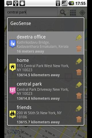
GeoSense is an unique application that helps you remember and reminds you of locations.
· Add any number of locations to from the map.
· Location alerts to each hotspot.
· Location reminders when you come within the specified proximity.
· Add categories to POIs
· Lists POIs based on distance from you.
· Intelligent battery use.
Like it? Share with your friends!
Supported operating systems:
Google Android 1.5, Google Android 1.6, Google Android 10.x, Google Android 2.0, Google Android 2.1, Google Android 2.2, Google Android 2.3, Google Android 3.0, Google Android 3.1, Google Android 3.2, Google Android 4.0, Google Android 4.1, Google Android 4.2, Google Android 4.3, Google Android 4.4, Google Android 5.x, Google Android 6.x, Google Android 7.x, Google Android 8.x, Google Android 9.x
Similar Software:
Quovady for Android Quovady is a service that allows you to ask your friends, your family or coworkers "where are you?", let them know of your whereabouts or track their location if they gave you permission to do so
NAVIGON USA & Canada for Android NAVIGON USA & Canada for Android - NAVIGON turns your mobile device into a fully featured GPS navigation system. The software provides advanced functionality for both drivers and pedestrians, including 2D and 3D maps, route planner, speed assistant, voice directions, local search, and more
Turbo GPS Turbo GPS - The known all-in-one GPS and Sensor manager, now for Android.
Supports waypoints, tracks, sensors, compass, import/export, routes, 3D map and more.
What's New in This Release:
· Less size
· Updated Map when Tracks are drawn
· Fixed bug when Running track (direction arrow)
Phone Tracker (GPS Phone Tracking) Phone Tracker (GPS Phone Tracking) - The Phone Tracker is a free service that uses GPS technology to help you follow friends/family and see their exact location on a map. You will be able to securely track both iPhones and Androids, view their movements, and see up to 72 hours of their travel location history. ✓ Follow your child's movements during the day
Navitel Navigator for Android Navitel Navigator for Android - Navitel Navigator is a GPS travel assistant for Android. The app turns your phone into a personal navigation system.
Navitel Navigator comes with detailed maps and other useful features, including traffic jams, speedcams, 3D roads and intersections, instant routing and a comprehensive database with points of interest
WAY - Where are you? WAY - Where are you? - Share you location and find your friends easily.
Wanna find your friends?
Wanna share your location with friends?
Congratulations: YOU FOUND THE APPLICATION WHICH ALLOWS YOU THAT AND EVEN MORE.
"WAY - Where are you?" allows you to find your friends' locations in real time and/or send them free messages
CompassNavi Compass / Navigation Activity, mainly for OpenGPX, but can be used from any application
meet-me FREE meet-me With only a few fingertips you can find your friends in the biggest crowd. Their location is presented by a stylish arrow and distance. Awesome: the positions are dynamically updated
Automobile Locator This app has a rotating arrow that points in the direction of your car. It allows you to mark your cars location using GPS. You can then use it at a later time to help guide you back to where you parked
My.POI 3 000 000 POIs from Shturmann® database on your Android phone
Other Software by developer «Dexetra»:
Tintumon: Rebirth Tintumon: Rebirth - The kingdom of Mallusia is under siege by the Evil Kanka and his men
SpeedSense SpeedSense turns your Android phone into a virtual Dashboard. You get all sorts driving info, such as:
* Top Speed
* Avg