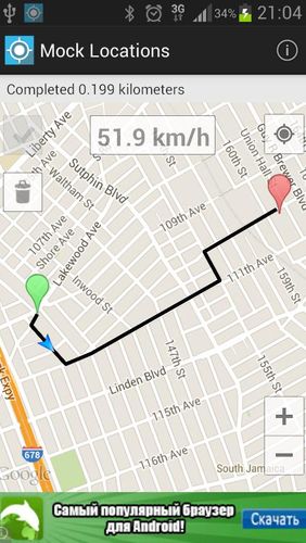
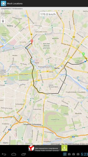
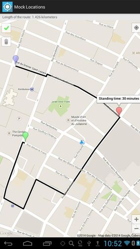
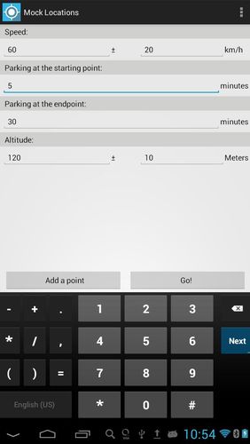
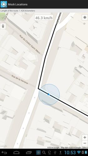
Mock locations - is an application which will help you hide your location. With its help you can set 2 certain points and make your device move between these points.When you will view the covered distance on google maps, it will show you not the place you were for real.
Game features:
Fake GPS location
You can lay and set route details
Circle route
Simple and comprehensive interface
Loading video...
Like it? Share with your friends!
Supported operating systems:
Google Android 4.1, Google Android 4.2, Google Android 4.3, Google Android 4.4, Google Android 5.x, Google Android 6.x, Google Android 7.x, Google Android 8.x
Similar Software:
GeoPix GeoPix - Headed to work or class? Want your school's mascot or company logo to show up as your wallpaper, "abracadabra" style, just as you arrive? Simply choose an image from Myxer’s massive catalog of wallpapers, or grab one from your phone, set the address- and watch it "auto-magically" appear as you reach your destination
amAze (Samsung) AmAze is a first of its kind free navigation and local search service. It is free to download and use and it contains wide coverage of maps including aerial photo in Europe, North America, Australia and parts of Asia and Africa
GPShake Lite With GPShake you can track your GPS location, create GPX files, whenever you want with a shake of your phone! This means battery life saving! A great usage example could be when you want to geotagging your photo made with an external camera
DEWA (Android) DEWA - Welcome to the Mobile World of DEWA
OakLogAndroid OakLogAndroid Logger application for your Android device. Records GPS and sensor information on your phone.
The log files (*.olg) can later be loaded into TrackView.NET and viewed in all their 3D-glory.
· Logs GPS position, altitude, speed, etc
DondeEsta - ultimate SMS mobile tracking system! DondeEsta - ultimate SMS mobile tracking system! - LOCATE YOUR FAMILY SIMPLE SENDING SMS
Install the application in the mobile to be located (i.e. your kid's mobile)
Mobile tracking for family safety.
Locate your children.
Locate elderly.
Locate for your own safety.
Easily alert your family when you are in a trouble!
DondeEstaTM brings peace of mind
Turbo GPS Turbo GPS - The known all-in-one GPS and Sensor manager, now for Android.
Supports waypoints, tracks, sensors, compass, import/export, routes, 3D map and more.
What's New in This Release:
· Less size
· Updated Map when Tracks are drawn
· Fixed bug when Running track (direction arrow)
OS Map OS Map is a tool to turn your Android phone into a handy Ordnance Survey map, with your GPS position pinpointed on it!
· Nearly all OS Map scales available (including 250,000 and 50,000).
· Touch-scrolling - simply use your finger to drag the map around.
· Fast resume from standby and fast position updates
Comments on Mock locations - Fake GPS path:
sara:
Hello sara
Date: 13 Jun 22
English(us):
Kadakada
Date: 15 Aug 22
If you noted an error or download link is broken, please, report it via this page or use comments.
Mock locations - Fake GPS path is compatible with your device Omate X Smartwatch


")

")


")
